


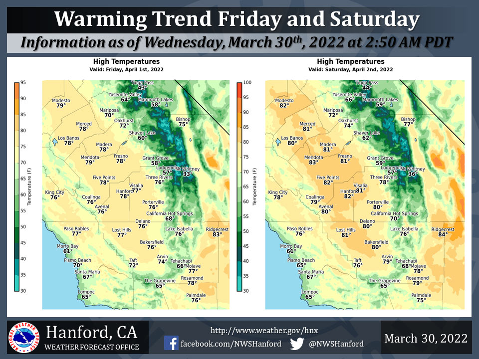
Mariposa projected high temperature for Friday: 70 degrees, Saturday: 72 degrees
Oakhurst projected high temperature for Friday: 72 degrees, Saturday: 74 degrees
Yosemite Valley projected high temperature for Friday: 64 degrees, Saturday: 66 degrees
March 30, 2022 - The National Weather Service Hanford Office reports high temperatures throughout Central California Friday afternoon will be five to seven degrees warmer than Thursday afternoon.
Maximum temperatures across Central California Saturday afternoon will be three to five degrees warmer than Friday afternoon.
High temperatures throughout Central California Saturday afternoon will be around ten degrees above normal for this time of year.
  Area Forecast Discussion
  National Weather Service Hanford CA
  104 AM PDT Wed Mar 30 2022

  .SYNOPSIS...
  High temperatures this afternoon will be around five degrees
  warmer than yesterday afternoon. Strong, gusty northwest winds are
  likely in the Mojave Desert Slopes this afternoon and tonight. A
  warming trend is expected Friday and Saturday. By Saturday
  afternoon, maximum temperatures will be eleven to thirteen degrees
  above normal for this time of year.

  &&

  .DISCUSSION...
  A ridge of high pressure over California will move eastward into
  the Great Basin this afternoon. Maximum temperatures this
  afternoon will be about five degrees warmer than yesterday
  afternoon. A trough of low pressure will dig southward over Nevada
  tonight. Strong, gusty northwest will likely develop in the Mojave
  Desert Slopes ahead of this trough this afternoon. These strong,
  gusty northwest winds should persist into early Thursday morning.
  A Wind Advisory is in effect for the Mojave Desert Slopes. A
  ridge of high pressure will progress eastward over the Eastern
  Pacific Ocean Thursday, before making landfall along the west
  coast of the United States Thursday night.

  The aforementioned ridge of high pressure will move eastward
  through the Western United States Friday and Friday night. A
  feeble trough of low pressure will progress eastward over Northern
  California Saturday afternoon. A warming trend is anticipated
  Friday and Saturday. Maximum temperatures Friday afternoon will
  be around five degrees warmer than Thursday afternoon. High
  temperatures Saturday afternoon will be eleven to thirteen degrees
  above their typical values for the beginning of April. A few
  showers cannot be ruled out in the Sierra Nevada Saturday
  afternoon and Saturday evening, mainly along the crest. A stronger
  trough of low pressure will deepen as it crosses California Sunday
  afternoon and Sunday evening. Strong, gusty west winds are
  possible in the Kern County desert Sunday afternoon and Sunday
  night. Once again, a few showers cannot be ruled out in the Sierra
  Nevada Sunday afternoon and Sunday evening, mainly along the
  crest. A downward temperature trend is expected late this weekend
  into early next week. Be that as it may, temperatures will remain
  above seasonal values.

  &&

  .AVIATION...
  MVFR visibilities are likely in areas of mist in the San Joaquin
  Valley until 17Z this morning. Otherwise, VFR conditions will
  prevail in Central California through at least the next 24 hours.

  &&

  .AIR QUALITY ISSUES...
  None.
Source: NWS
