


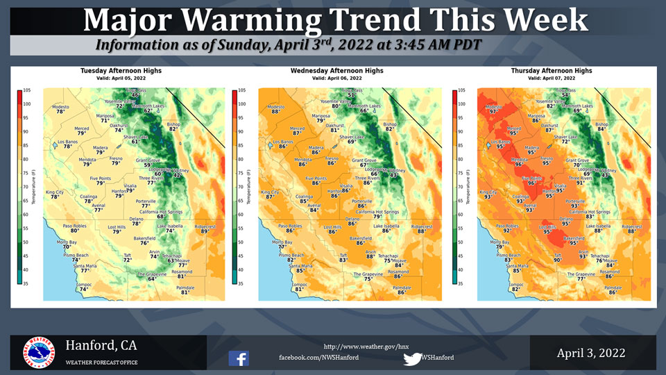
Mariposa Projected High Temperatures for Tuesday, Wednesday and Thursday Range from 71-86 Degrees
Oakhurst Projected High Temperatures for Tuesday, Wednesday and Thursday Range from 74-87 Degrees
Yosemite Valley Projected High Temperatures for Tuesday, Wednesday and Thursday Range from 72-82 Degrees
April 3, 2022 - The National Weather Service Hanford Office reports a major warming trend is forecast to occur this week as a strong ridge of high pressure builds over the area.
Afternoon temperatures are forecast to be around 20 to 23 degrees above normal by Thursday with record highs likely.
Little changes are expected on Friday with more record highs likely.
  Area Forecast Discussion
  National Weather Service Hanford CA
  310 AM PDT Sun Apr 3 2022

  .SYNOPSIS...Temperatures will remain well above normal today. A
  slight cooling trend will take place on Monday with breezy
  conditions this evening through Monday morning. A sharp wamring
  trend will take place later this week with temperatures rising to
  around 20 degrees above normal Thursday and Friday with record
  high temperatures likely.

  &&

  .DISCUSSION...IR imagery showing abundant high clouds streaming
  over central CA this morning ahead of an upper trough which is
  approaching the western CONUS coast. The trough is progged by the
  SREF to push through our area later today which will result in
  breezy to windy conditions across portions of the Kern County
  Deserts this evening through early Monday. A Wind Advisory remains
  in effect for the Mojave Desert Slopes and the Mojave Desert area
  in Kern County between 300 pm PDT this afternoon and 800 am
  Monday. While moisture is limited with this system, instability
  will be sufficient enough for a slight chance of showers this
  afternoon over the higher elevations of the Sierra Nevada south of
  Kings Canyon. The other impact that this system will be a slight
  cooling trend across the area with low temperatures on Monday
  morning being 3-6 Deg F low that this morning at most locations
  and daytime highs being slightly lower at most locations despite
  clearing skies by Monday.

  SREF is continuing to indicate a strong upper ridge building into
  CA on Tuesday and Wednesday. This will result in mainly clear
  skies, dry weather and noticable warming trend across the area
  with daytime temepratures expected to be around 15 Deg F above
  normal by Wednesday.

  Medium range ensemble means are showing the ridge strengthening
  further later in the week with 500 mb heights progged to be around
  585 dm. This will result in near record daytime temperatures
  across our area on Thursday and Friday. Latest NBM probabilistic
  guidance is indicating a 75 to 90 percent chance of high
  temperatures exceeding 90 Deg F and a 30 to 50 percent chance of
  high temepratures exceeding 95 Deg F on Thursday and again on
  Friday.

  Another upper trough is progged to push through CA next weekend
  which will result in a cooling trend across our area although
  temperatures are expected to remain above climatological normals.
  Latest NBM probabilistic guidance continues to indicate the
  chance of precipitation across our area next weekend are less
  than 10 percent.

  &&

  .AVIATION...Areas of MVFR visibility in blowing dust in the Kern
  County Deserts after 18Z today. Areas of MVFR and local mountain
  obscuring IFR between 20Z today and 03Z Monday in showers over the
  Sierra Nevada south of Kings Canyon. Otherwise, VFR conditions
  will prevail across the Central CA interior through at least the
  next 24 hours.

  &&

  .AIR QUALITY ISSUES...None.
Source: NWS
