


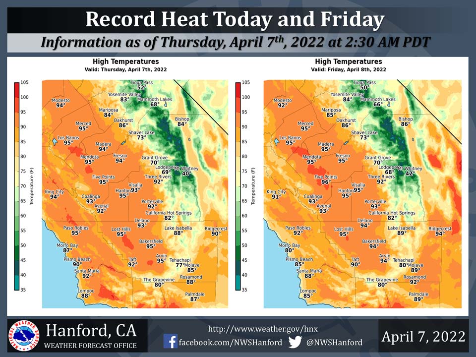
Mariposa projected high temperature for Thursday: 84 degrees, Friday: 85 degrees
Oakhurst projected high temperature for Thursday: 86 degrees, Friday: 86 degrees
Yosemite Valley projected high temperature for Thursday: 83 degrees, Friday: 84 degrees
April 7, 2022 - The National Weather Service Hanford Office reports high temperatures throughout the San Joaquin Valley this afternoon and Friday afternoon will be in the mid 90s, which is twenty-one to twenty-three degrees above normal for this time of year.
Record heat is expected in most of the San Joaquin Valley this afternoon and Friday afternoon.
A cooling trend is likely Saturday into early next week.
  Area Forecast Discussion
  National Weather Service Hanford CA
  1245 AM PDT Thu Apr 7 2022

  .SYNOPSIS...
  High temperatures this afternoon and Friday afternoon will be
  twenty-one to twenty-three degrees above normal for this time of
  year. As a result, record heat is expected in most of the San
  Joaquin Valley this afternoon and Friday afternoon. A cooling
  trend is likely Saturday through Tuesday. There is a slight
  chance of precipitation Monday afternoon into Tuesday.

  &&

  .DISCUSSION...
  A ridge of high pressure will remain over California today. This
  ridge of high pressure will slide eastward into the Great Basin
  tonight into Friday. Maximum temperatures this afternoon and
  Friday afternoon will be twenty-one to twenty-three degrees above
  their typical values for the first half of April, resulting in
  record heat in much of the San Joaquin Valley. Record heat is
  expected in Merced (92% probability), Madera (84% probability),
  and Hanford (82% probability) this afternoon. Record heat is
  likely in Fresno (64% probability) this afternoon. There is a
  slight chance of record heat in Bakersfield (27% probability) this
  afternoon. Record heat is expected in Merced (86% probability),
  Hanford (85% probability), and Madera (80% probability) Friday
  afternoon. Record heat is likely in Fresno (71% probability)
  Friday afternoon. There is a slight chance of record heat in
  Bakersfield (20% probability) Friday afternoon.

  A trough of low pressure will progress eastward across the
  Pacific Northwest Saturday. Strong, gusty winds are possible in a
  portion of the Kern County mountains and desert Saturday afternoon
  and Saturday evening. A cyclone aloft will drop southward, just
  off the coast of Western Canada Sunday. This upper-level area of
  low pressure will pivot eastward into the Pacific Northwest
  Monday. A cold front may move southward across Central California
  Monday night or Tuesday. There is a slight chance of precipitation
  across most of the service area ahead of and along this cold
  front Monday afternoon into Tuesday. A cooling trend is expected
  Saturday through Tuesday. Maximum temperatures Saturday afternoon
  will be twelve to fourteen degrees lower than Friday afternoon.
  Maximum temperatures Sunday afternoon will be around five degrees
  lower than Saturday afternoon. High temperatures Monday afternoon
  will be about five degrees cooler than Sunday afternoon. By
  Tuesday afternoon, high temperatures will be six to eight degrees
  below normal for this time of year. The start of a warming trend
  is expected Wednesday.

  &&

  .AVIATION...
  VFR conditions will prevail across Central California through at
  least the next 24 hours.

  &&

  .AIR QUALITY ISSUES...
  None.
Source: NWS
