


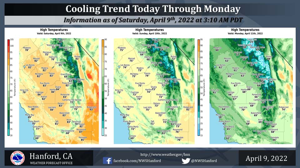
Mariposa Projected High Temperatures for Saturday through Monday: Range from 75-51 Degrees
Oakhurst Projected High Temperatures for Saturday through Monday: Range from 78-54 Degrees
Yosemite Valley Projected High Temperatures for Saturday through Monday: Range from 75-50 Degrees
April 9, 2022 - The National Weather Service Hanford Office reports maximum temperatures throughout Central California this afternoon will be eleven to thirteen degrees lower than yesterday afternoon.
High temperatures across Central California Sunday afternoon will be eight to ten degrees cooler than Saturday afternoon.
By Monday afternoon, maximum temperatures throughout Central California will be seven to nine degrees below normal for this time of year.
  Area Forecast Discussion
  National Weather Service Hanford CA
  132 AM PDT Sat Apr 9 2022

  .SYNOPSIS...
  Strong, gusty winds are likely in the Coastal Range, Kern County
  Desert, and northwestern portion of the San Joaquin Valley today.
  A cooling trend is expected today through Monday. By Monday
  afternoon, high temperatures will be around ten degrees below
  normal for this time of year. Precipitation is possible ahead of
  and along a cold front Monday afternoon into early Tuesday.

  &&

  .DISCUSSION...
  A trough of low pressure will move eastward across the Pacific
  Northwest today. Northwest wind gusts near 35 mph are likely in
  the Coastal Range and northwestern portion of the San Joaquin
  Valley today. West to northwest wind gusts near 55 mph are
  probable in the Kern County Desert today into early Sunday
  morning. Wind Advisories are in effect for the aforementioned
  locations. A cyclone aloft will slowly move southward down the
  western coast of Canada tonight through Sunday night. This upper-
  level area of low pressure will pivot eastward into the Pacific
  Northwest Monday morning. A cooling trend is expected today
  through Monday. Maximum temperatures this afternoon will be twelve
  to fourteen degrees lower than yesterday afternoon. High
  temperatures Sunday afternoon will be six to eight degrees cooler
  than this afternoon. By Monday afternoon, maximum temperatures
  will be around ten degrees below normal for this time of year.

  A cold front will approach Central California Monday afternoon.
  This cold front should move southward across the service area
  Monday night. Precipitation is possible ahead of and along this
  cold front Monday afternoon and Monday night. Precipitation should
  end in most locations Monday night, although upslope flow in the
  Kern County mountains may be responsible for light precipitation
  early Tuesday morning. Rain amounts should be one tenth of an inch
  or less in the San Joaquin Valley Monday afternoon and Monday
  night. Rain amounts should be one quarter of an inch to one half
  of an inch in the Sierra Nevada foothills Monday afternoon and
  Monday night. The snow level will start at around 5,000 feet
  Monday afternoon, before falling to about 3,000 feet Monday night.
  In the Sierra Nevada, snow accumulations of four to eight inches
  are expected above 7,000 feet. Snow accumulations of two to four
  inches anticipated from 4,000 feet to 7,000 feet Monday and Monday
  night. Snow accumulations of an inch or less expected from 3,000
  feet to 4,000 feet Monday and Monday night. Snow showers are
  possible along Interstate 5 over Tejon Pass and along Highway 58
  over Tehachapi Pass late Monday night into early Tuesday morning.
  Snow amounts will be less than an inch, but icy road conditions
  could cause hazardous travel.

  The main storm track will remain north of California Tuesday night
  through Friday. A warming trend is expected Wednesday through
  Friday. Maximum temperatures Wednesday afternoon will be three to
  five degrees higher than Tuesday afternoon. Maximum temperatures
  Thursday afternoon will be around five degrees higher than
  Wednesday afternoon. By Friday afternoon, high temperatures should
  be near normal for this time of year.

  &&

  .AVIATION...
  VFR conditions will prevail across Central California through at
  least the next 24 hours.

  &&

  .AIR QUALITY ISSUES...
  None.
Source: NWS
