


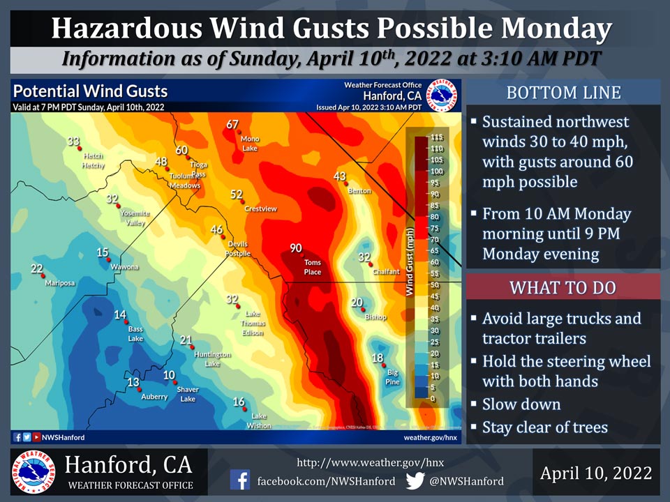
April 10, 2022 - The National Weather Service Hanford Office reports hazardous northwest wind gusts are possible in the higher elevations of Yosemite National Park Monday.
Damaging wind gusts may blow down trees.
Here are projected wind gusts valid at 3:00 P.M. Monday, April 11th, 2022.
  Area Forecast Discussion
  National Weather Service Hanford CA
  355 AM PDT Sun Apr 10 2022


  .SYNOPSIS...
  High temperatures will continue to drop and be around ten degrees
  below normal for this time of year by Monday. Precipitation and
  strong winds are possible ahead of and along a cold front Monday
  afternoon into early Tuesday.

  &&

  .DISCUSSION...
  The passage of a dry cold front on Saturday ushered in a change
  in Central Californias weather. The strong winds of the Spring
  season are in full force as the winds blew on Saturday. Observed
  wind gusts were able to reach 20 to 30 mph as the cold front sweep
  across the region. Along with the strong winds, the cold front
  did manage to push out the strong ridge pattern that had been over
  the West Coast for several days. After several days of having
  temperatures reach into the 90s, the San Joaquin Valley barely
  reached the 80 degree mark on Saturday. Central California will
  remain under a cyclonic flow pattern for several days as
  temperatures continue a downward trend as a storm approaches the
  district this week. Unsettled weather conditions are expected
  across the Central California Interior as rain, snow and strong
  winds return once again.

  Ensemble are still calling for a possible winter-like storm early
  this week. Confidence is high in the break down of the ridge
  pattern as a rather cold disturbance moves through the region.
  Temperatures have started a down turn to more seasonal normal
  values. Ensemble are struggling to see temperatures exceeding 90
  degrees by Sunday afternoon. This low value in the probability of
  exceedance for near 90s will increase confidence in much cooler
  conditions at the start of next week. Observed surface pressure
  analysis is currently showing the gradient from KSFO to KLAS
  dropping below 10mb. Will expect the gradient to drop further as
  wind speeds continue to lower this morning. While temperatures
  will remain cooler this week, winds will see another rise as it
  accompanies a winter-like storm on Monday and Tuesday.

  Ensemble upper air analysis is still indicating very cold air
  surging into Central California on Monday and into Tuesday. Along
  with a possible storm that may drop into the district from along
  the coast, ensembles indicate more snow for the Sierra Nevada by
  Tuesday. Some uncertainty exist with the timing of the disturbance
  as its instability may remain too far north for any convective
  activity on Monday. Ensembles do show some weak cape extending
  into the northern portions of the district (Merced Co., Mariposa
  Co. and Yosemite NP) late Monday, yet, convective showers are
  possible. Based on snow amounts, weak cape may add extra support
  for the Weather Weather Advisory currently in effect for the
  Sierra Nevada. While minor compared to previous storms, any
  precipitation will help Central California. In addition to the
  continued indication of possible precipitation, ensemble also
  continue to indicate very low snow levels with this next storm.
  Confidence is growing that some foothill locations could see a
  dusting of snow with the storm. Afterward, ensemble show dry
  conditions ahead of another possible storm around the Friday time
  frame. Hopefully, ensembles will on to this next possible storm
  for additional precipitation.

  &&

  .AVIATION...
  VFR conditions will prevail across Central California through at
  least the next 12 hours. Precipitation will return to Central
  California Monday morning as MVFR and strong winds enter the area.

  &&

  .AIR QUALITY ISSUES...
  None.
Source: NWS
