


California and National Drought Summary for April 12, 2022
Summary
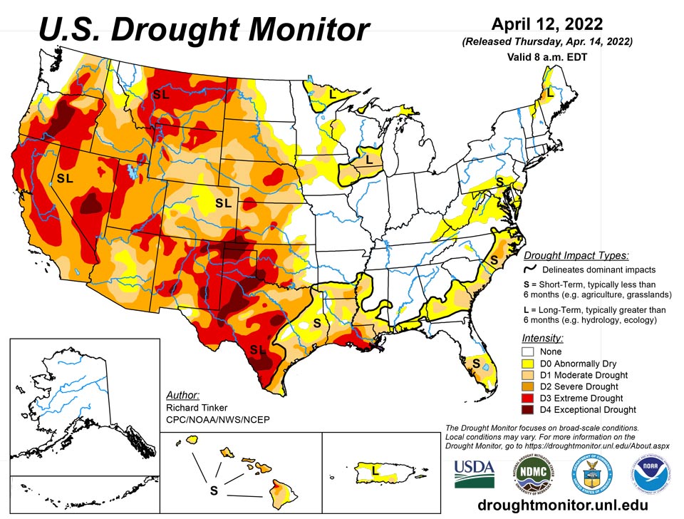
April 14, 2022 - A series of storms dropped moderate to heavy precipitation on much of the eastern half of the country, with 3 to locally 6 inches of rain falling on a swath from central Alabama to central South Carolina, near the Mississippi and Ohio Rivers confluence, areas from the Delmarva Peninsula to southeastern New York state, and portions of the Cascades and coastal areas in Washington and portions of Oregon. Temperatures did not average far from normal except in the southwestern and northeastern parts of the country. The Southwest, The Great Basin, most of California, and New England experienced temperatures up to 5 deg. F in spots. In addition, episodes of low humidity and strong winds worsened dryness across much of the Plains and adjacent Rockies.
Northeast
Low pressure centers moving through the Nation’s midsection brought periods of moderate to locally heavy precipitation during the week. Most locations from the middle Atlantic and central Appalachians northward through western New England recorded at least 1.5 inches, with a few areas from southeastern New York to the Delmarva Peninsula receiving 3.5 to locally 5.0 inches of precipitation. In much of New Jersey, it was the wettest week since October 2021. The widespread precipitation eased dryness and drought across the middle Atlantic region, especially across southeastern Pennsylvania and parts of New Jersey. Farther north, precipitation totals were mostly below an inch, leaving dryness and drought mostly unchanged. Small areas of improvement were noted in the southern reaches of the dry region there. Over the last 6 months, precipitation deficits of 4 to locally 12 inches have accumulated in the northern and western sections of New England, and parts of the middle Atlantic region from south-central and east-central Pennsylvania, parts of northern and southern Maryland, and southeastern New England.
Southeast
A swath of moderate to heavy precipitation was observed from southern Mississippi through most of Alabama, Georgia, and South Carolina. Amounts exceeding 1.5 inches were common, with patches of 3.5 to 6.0 inches from east-central Alabama through central Georgia to central South Carolina. A few other areas reported between 1 and 2 inches in northern Virginia, southern and eastern North Carolina, the western Florida Peninsula, and along the Georgia/Florida border. Meanwhile, only a few tenths of an inch at best fell on the Florida Peninsula, southeastern Georgia, much of Mississippi and northern Alabama, and areas near the central Virginia/North Carolina border. This pattern brought significant relief to the recent stripe of dryness and drought across much of the interior Southeast, restricting severe dryness (D2) to interior eastern North Carolina and a few spots in westernmost Mississippi. Also, a swath of moderate drought (D1) remains in most of the eastern Carolinas, parts of southern Georgia, and much of southern and western Mississippi. Parts of northern Virginia also saw limited improvement, leaving most of the region covered by D0 (abnormal dryness). Meanwhile, dryness and drought intensified and expanded somewhat across southern Florida, where most areas recorded no precipitation. Severe drought (D2) was introduced in southwestern Florida, with moderate drought stretching across most of central and southern Florida. For the past 9 months, precipitation totals were among the lowest 10 percent of the historical distribution in eastern North Carolina, with a few sites measuring totals among the lowest 2 percent of the climatological envelope. Over the past 2 months, less than half of normal precipitation fell on interior eastern North Carolina, and the central and upper southern sections of the Florida Panhandle, with part of southwestern Florida accumulating only 0.5 to 2.0 inches total
South
Only limited areas recorded light to moderate precipitation, with most sites reporting little or none. Between 2 and 4 inches fell on small areas in northeastern Oklahoma, northeastern Arkansas, and northwestern Tennessee. Most other areas of northern Tennessee observed 1.5 to 2.5 inches, and similar amounts fell on much of northern Arkansas and parts of eastern Louisiana. Several tenths of an inch were measured in the rest of Tennessee and central Louisiana, but a majority of the Region – including almost all of Texas and Oklahoma – experienced a precipitation-free week. In general, dryness and drought worsens moving from northeast to southwest across the South Region. Eastern Oklahoma, central and northern Arkansas, and almost all of Tennessee are free of significant dryness. In sharp contrast, D2 to D4 drought covers southern Louisiana, most of the western half of Oklahoma, and the central and eastern reaches of Texas. Exceptional drought (D4) covers several sizeable areas in the western half of Texas and the Oklahoma Panhandle. Only a few tenths of an inch of precipitation has fallen at best since early February across central and south-central Texas, with 17 sites reporting rainfall totals among the driest 2 percent of the historical distribution for the period, as did a few sites in northwestern Texas outside the Panhandle. For the past half-year as a whole, less than 10 percent of normal precipitation has been observed in part of west-central Texas, including much of the Big Bend, while less than 25 percent of normal fell on most of the western half of Texas and the Oklahoma Panhandle. In addition, episodes of low humidity and strong winds worsened the situation across the already-parched region, leading to high wildfire danger and areas of blowing dust.
Midwest
Several weeks of substantial precipitation have progressively improved conditions, and now lingering long-term D0 and D1 conditions are confined to areas west of Lake Michigan. This past week, 1 to 2 inches fell on a few patches across the northern tier of the Midwest Region. Six-month precipitation totals between 2 and 5 inches below normal exist only across northern Iowa, a band from southeastern Iowa to central Missouri, and a few patches on the Michigan Upper Peninsula, west-central lower Michigan, southwestern Wisconsin, and northwestern Illinois. There are higher deficits in small parts of southern and western Missouri on the fringes of the large drought area that has enveloped most of the western half of the country.
High Plains
An inch or two of precipitation fell on northwestern South Dakota, a small part of eastern North Dakota, and the highest elevations of north-central Colorado. Elsewhere, a few areas of 0.5 to 1.0 inch was observed in parts of the central and southern Dakotas, northwestern Nebraska, and several swaths scattered across Wyoming. A few tenths of an inch, at best, fell elsewhere. Dryness and drought cover a large majority of the High Plains Region; only the east-central and northeastern Dakotas and eastern Kansas are free of any significant dryness. D2 to D3 cover central and western parts of the Region, including all of Wyoming, Colorado, and most of Nebraska. Slow intensification and expansion has been noted across many areas over the past several months, and D3 expanded to cover additional portions of north-central Wyoming, central Nebraska, and an area near the western Kansas/Nebraska border. Elsewhere, few changes were introduced. Recently, strong winds and low humidity have made dryness more acute, especially in southern parts of the Region.
West
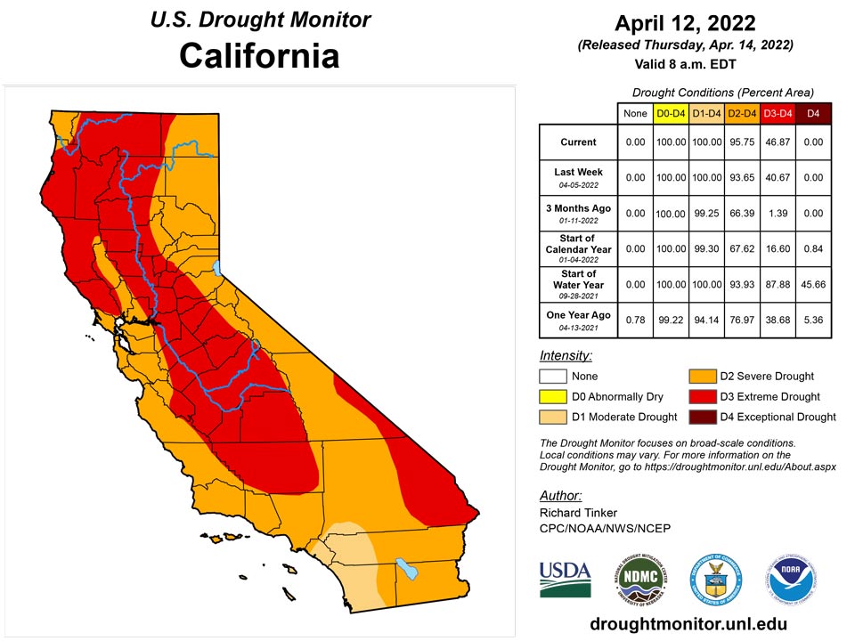
The West Region endured another dry week, with the heaviest precipitation falling along and west of the Cascades in Washington and northern Oregon (generally 1.5 to 3.5 inches, with isolated amounts reaching 6 inches in the highest elevations). This is one of two areas free of dryness and drought (northwestern Montana and adjacent Idaho is the other). D2 and D3 cover a large majority of the West Region, and exceptional drought (D4) has become entrenched in the Oregon Cascades, south-central Nevada, parts of southern New Mexico, and northeastern New Mexico. Slow worsening and expansion continued, with noticeable deterioration in parts of New Mexico, Nevada, and California this week. Water storage in the two largest reservoirs in the west – Lake Powell along the central Arizona/Utah border, and Lake Mead farther downstream along the Colorado River – has dropped to unprecedented levels. In early April, the combined storage was only 44 percent of the average since 1964, and less than 75 percent of the storage in Lake Mead alone just before Lake Powell started to fill.
Caribbean
The depiction in Puerto Rico was unchanged.
All three U.S. Virgin Islands remained the same this week with St. Thomas at D1-L, St. Croix at D2-L and St. John at D1-L.
St. Thomas received from 0.07 inches to 0.60 inches this week, according to CoCoRaHS observers on the island. SPIs ranged from slightly wet at 3 months to moderate drought at 9 months. The Grade School 3 Well was at 13.58 feet below land surface, which is fairly low for the well.
St. Croix’s CoCoRaHS observers reported from 0.13 inches to 0.26 inches for the week. SPIs varied from wet conditions at 3 months to moderate drought at 1, 9, and 12 months. The Adventure 28 Well was at 31.63 feet below land surface, a record low and the level continues to drop, indicating significant dryness.
St. John received 0.70 inches and 0.79 inches as reported by CoCoRaHS observers. SPIs ranged from wet conditions at 3 months to severe drought at 6 months. The Susannaberg DPW well was quite low at 19.71 feet below land surface.
Pacific
In Hawaii, light trade winds restricted rainfall to the windward slopes and the Kona slopes. Improved agricultural conditions led to an improvement to D1 in west-central parts of the Big Island, and increased streamflows prompted improvement to D1 in eastern Molokai as well. There was an area of deterioration on Kahoolawe (to D3) where satellite-derived vegetative indexes have deteriorated.
Alaska remains drought-free this week.
The Republic of Palau received more than 7 inches rain and remains free of dryness. Two inches of rain weekly is enough to meet minimum water needs for these and most other U.S. Affiliated Pacific islands.
The Mariana Islands received enough rain to ease dryness somewhat. Guam received 1.35 and 1.82 inches in the past two weeks, allowing moderate drought (D1) to be improved to abnormal dryness (D0) as these islands need an inch weekly to meet minimum water needs. Rota benefited from 1.40 and 3.37 inches in past weeks, so Rota was improved to drought-free conditions. Saipan received from 0.85 to 1.88 inches and remained abnormally dry.
The Federal States of Micronesia received plenty of rain at most locations. Kapingamarangi was the one location that remained at D0-S and received 1.40 inches. Data for Lukunor was scarce with several days missing, but the location received plenty of rain in previous weeks and remained free of dryness. Other locations reported from 4.42 inches to 14.00 inches this week.
The Marshall Islands were mostly free of drought, apart from Wotje, which remained at D3-SL and reported no rain this week. Rainfall at Kwajalein was 1.79 and 1.48 in past weeks and remained free of dryness. All other locations reported from 4.57 inches to 12.32 inches for the past week, which is plenty of rain.
American Samoa remained free of dryness. Pago Pago reported 0.90 inches, Siufaga Ridge got 0.62, and Toa Ridge received 0.60 inches. These locations received enough rainfall in recent weeks to have adequate supplies.
Looking Ahead
The storm system bringing blizzard conditions to the northern Plains will be moving out, followed by a late-season outbreak of Arctic air. Unseasonably low temperatures will push through much of the Nation during April 14 – 18, 2022. Daytime maximum temperatures will average at least 3 deg. F below normal everywhere outside the Atlantic Seaboard and the southern tier of the country from the Southeast to the desert Southwest. In the northern Plains and adjacent areas, daytime highs are expected to average 18 to 25 deg. F below normal. In contrast, highs should average 3 or more deg. F above normal from most of Texas through the Four Corners Region and parts of Nevada. The greatest departures from normal will be in the southern High Plains and lower Rio Grande Valley (+5 to +10 deg. F). Heavy precipitation (2 to 4 inches and locally more in higher elevations) is expected across central and southern parts of Mississippi and Alabama, southeastern North Carolina, upper New England, and the coastal and elevated parts of the Northwest from central Virginia to the Canadian Border. Moderate amounts (0.5 to 2.0 inches) should pelt the rest of the Pacific Northwest, most of the Southeast and the lower Mississippi Valley, most of the coastal Carolinas, southern New England and the adjacent Northeast, the northern Great Lakes Region, and the higher elevations of the northern Rockies. Meanwhile, light precipitation at best is expected across the southwestern quarter of the country, the central and eastern Plains, the upper Mississippi and Ohio Valleys, the Appalachians, and the middle Atlantic region.
The ensuing 5 days (April 19 – 23) should see below-normal temperatures lingering across the northern Great Plains and most locations from the Mississippi Valley to the Atlantic Coast. The northern Intermountain West, Pacific Northwest, and northern two-thirds of California are also expected to average colder than normal. Meanwhile, odds favor warmer than normal conditions across most of the Plains, Rockies, Great Basin, and Southwest. New Mexico, eastern Colorado, and adjacent areas have the best odds for above-normal temperatures. Above-normal precipitation is expected in New England, southwestern Texas and adjacent New Mexico, the upper Mississippi Valley, the northern Plains, and most places in and west of the Rockies outside the Southwest. Meanwhile, there are enhanced chances for subnormal precipitation from the central and southeastern Plains eastward through the Ohio Valley, much of the Mississippi Valley, the Appalachians, the Southeast, and the middle Atlantic region.
Author(s):
Richard Tinker, NOAA/NWS/NCEP/CPC
Denise Gutzmer, National Drought Mitigation Center
Dryness Categories
D0 Abnormally Dry—used for areas showing dryness but not yet in drought, or for areas recovering from drought.
Drought Intensity Categories
D1 Moderate Drought
D2 Severe Drought
D3 Extreme Drought
D4 Exceptional Drought
Drought or Dryness Types
S Short-term, typically less than 6 months (agriculture, grasslands)
L Long-term, typically more than 6 months (hydrology, ecology)
SL Area contains both short- and long-term impacts
Source: National Drought Mitigation Center
