


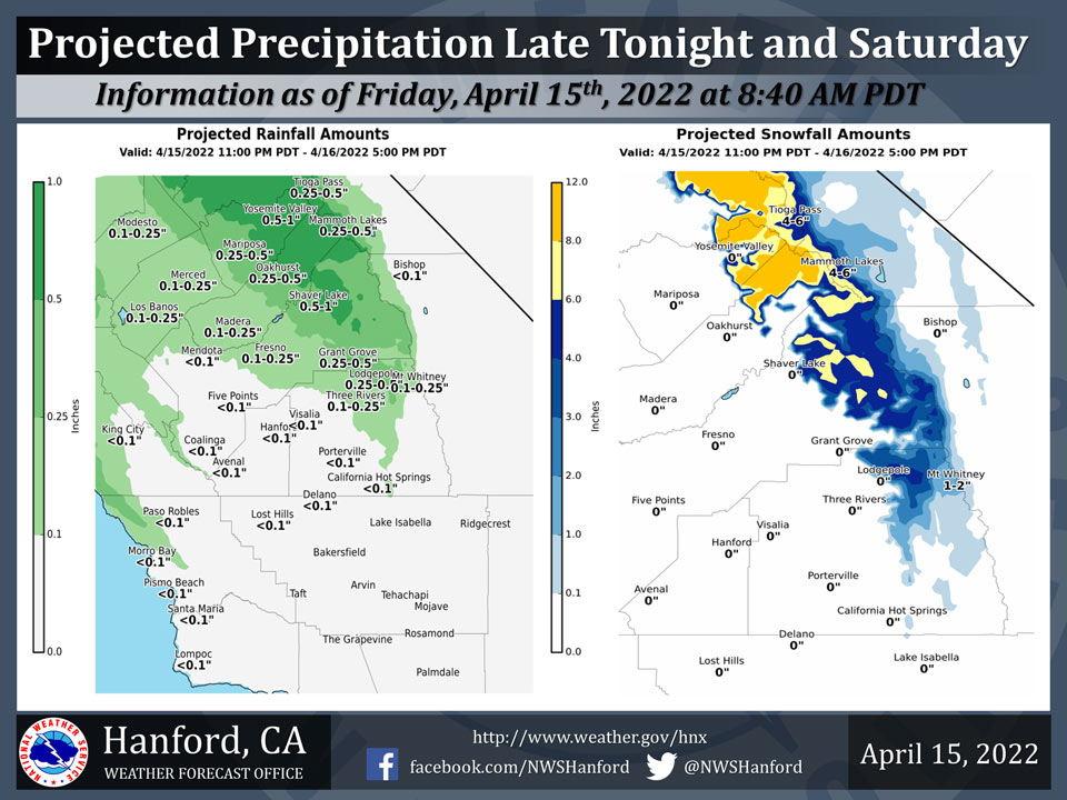
Projected Precipitation for Mariposa 0.25" - 0.50"
Projected Precipitation for Oakhurst 0.25" - 0.50"
Projected Precipitation for Yosemite Valley 0.50" - 1.00"
April 15, 2022 - The National Weather Service Hanford Office reports a trough of low pressure will pass across Central California Saturday.Precipitation is likely north of Kern County ahead of and along this trough of low pressure late tonight and Saturday.
A Winter Weather Advisory is in effect for elevations above 6,000 feet in the Sierra Nevada.
The majority of this precipitation will fall Saturday morning.
  Area Forecast Discussion
  National Weather Service Hanford CA
  439 AM PDT Fri Apr 15 2022


  .SYNOPSIS...
  Dry conditions and seasonable temperatures prevail today with
  gusty winds in the Kern County mountain passes this morning.
  A system will bring precipitation late tonight through Saturday
  afternoon, mainly north of Kern County. Dry conditions, light
  winds, and warmer temperatures are expected on Easter Sunday.

  &&

  .DISCUSSION...
  Satellite loops show mostly clear skies at this time as yesterday`s
  storm system exits to the east and the next upstream system quickly
  approaches from the eastern Pacific. Rainfall amounts were rather
  paltry with only a few hundredths to around one tenth of an inch
  measured, mainly around Yosemite NP. A good onshore flow continues
  with the SFO-LAS surface pressure gradient around 12 mb. Westerly
  wind gusts around 50 mph will continue in the Mojave Desert Slopes
  and the Indian Wells Valley in Kern County, where a Wind Advisory
  is in effect until 10 AM this morning. Mostly sunny skies should
  prevail this afternoon with temperatures near normal for this time
  of the year.

  An upper trough located around 39N/140W will track east southeast
  today and will begin to spread precipitation inland across central
  California late tonight. Latest high resolution guidance shows the
  precipitation beginning around Yosemite NP after midnight with an
  increasing chance through the morning. The progressive zonal flow
  will make this a relatively short-lived event with the bulk of the
  precipitation occurring from sunrise to Noon. Decreasing showers
  are expected during the afternoon then dry conditions by evening.
  Unfortunately, Kern County looks to get little if any precipitation
  from this system either. Rainfall amounts in the San Joaquin Valley
  north of Kern County are generally expected to be a few hundredths
  to one tenth of an inch, though isolated amounts up to two tenths
  are possible north of Fresno County. The Sierra Foothills could
  see up to one half of an inch of rainfall from Fresno County north.
  Sierra QPF is as much as one inch liquid around Yosemite NP with
  decreasing amounts to the south. A Winter Weather Advisory has been
  issued for the Sierra above 6000 feet from 5am to 5pm Saturday with
  snow accumulations of 3 to 9 inches and isolated amounts up to 12
  inches possible over the higher elevations around Yosemite NP. It
  will become windy again in the Kern County mountains and desert on
  Saturday but the timing is still uncertain. Will allow the current
  advisory for that area to expire later this morning before issuing
  one for Saturday.

  Upper ridging moves over on Sunday into Monday for dry weather and
  lighter winds. Global ensembles bring a system over the Pacific NW
  on Tuesday with a low chance for precipitation from Fresno County
  northward. Ensembles show potential for a stronger system tracking
  farther south around Thursday-Friday next week.

  &&

  .AVIATION...
  Wind gusts up to 45 knots possible over the mountains in eastern
  Kern County through 17z Friday. Otherwise, VFR conditions will
  prevail over the Central California Interior for the next 24 hours.

  &&

  .AIR QUALITY ISSUES...
  None.
Source: NWS
