


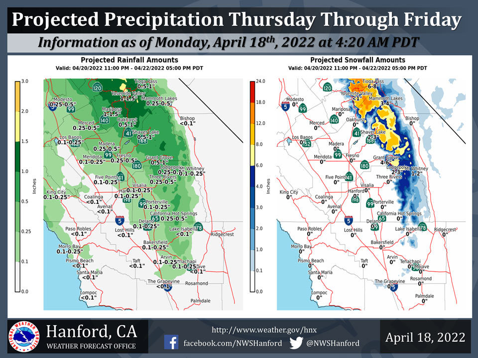
Projected Precipitation for Mariposa 1.00" - 1.50"
Projected Precipitation for Oakhurst 0.50" - 1.00"
Projected Precipitation for Yosemite Valley 1.00" - 1.50"
April 18, 2022 - The National Weather Service Hanford Office reports a significant storm system will produce precipitation across most of the area Thursday through Friday.Snow levels will start at around 7,000 feet Thursday, before dropping to about 5,000 feet by Friday morning.
One to two feet of snow is possible over the higher elevations of the Sierra Nevada in Yosemite Park while 9 to 18 inches of snow is possible over the higher elevations in Madera and Fresno Counties.
The majority of this precipitation will fall Thursday night.
  Area Forecast Discussion
  National Weather Service Hanford CA
  406 AM PDT Mon Apr 18 2022


  .SYNOPSIS...
  High pressure will provide for dry weather along with a warming
  trend through today. A weak system may bring some light
  precipitation to Fresno County northward on Tuesday. A stronger
  storm system is expected to impact our entire forecast area
  Thursday and Friday.

  &&

  .DISCUSSION...
  After a beautiful Easter Sunday, we can expect nearly the exact
  same conditions today...with some locations getting a degree or
  two warmer. Ensemble guidance from the NBM is advertising a trough
  to move across the region on Tuesday with temperatures dropping 5
  to 7 degrees and breezy conditions across the CWA. QPF amounts
  are expected to be light with up to 0.50" of liquid possible over
  Yosemite with snow levels around 6800 feet. Snow amounts of 2 to 4
  inches are possible in the higher elevations of the park.

  This system will quickly move out by Tuesday evening and a zonal
  flow sets up across the region with dry and seasonable
  temperatures for Wednesday. The NBM is advertising a stronger
  system to move into the region on Wednesday night and continue
  through Friday afternoon. Once again we are not expecting heavy
  rain in the SJV, with amounts of around 0.5" north of Fresno
  county to around a 0.1" near BFL. However we are expecting 1 to 2
  feet of snow in the high Sierra... especially over Yosemite
  National Park south to Sequoia National Park. Snow levels will
  start out around 7000 feet on Wednesday night and lower to around
  5000 feet by Friday afternoon. The bulk of the precip will occur
  with the frontal passage Thursday afternoon into Thursday night.
  We are expecting the chance of thunderstorms Thursday afternoon
  mainly Fresno county northward. Some storms may become strong with
  small hail, gusty winds and heavy rain. Winds will be gusty as
  the front pushes through Thursday across the Kern county desert.

  Showers are possible after the frontal passage through Friday as
  the upper level low pressure center moves across the region. We
  may see some isolated thunderstorms on Friday morning as well. The
  system clears out on Friday evening with a nice weekend in store
  next weekend. Near normal temps on Saturday and above just normal
  temperatures on Sunday and well above normal next Monday with dry
  conditions expected.

  &&


  .AVIATION...VFR conditions will prevail across the Central CA
  interior for at least the next 24 hours.

  &&

  .AIR QUALITY ISSUES...
  None.
Source: NWS
