


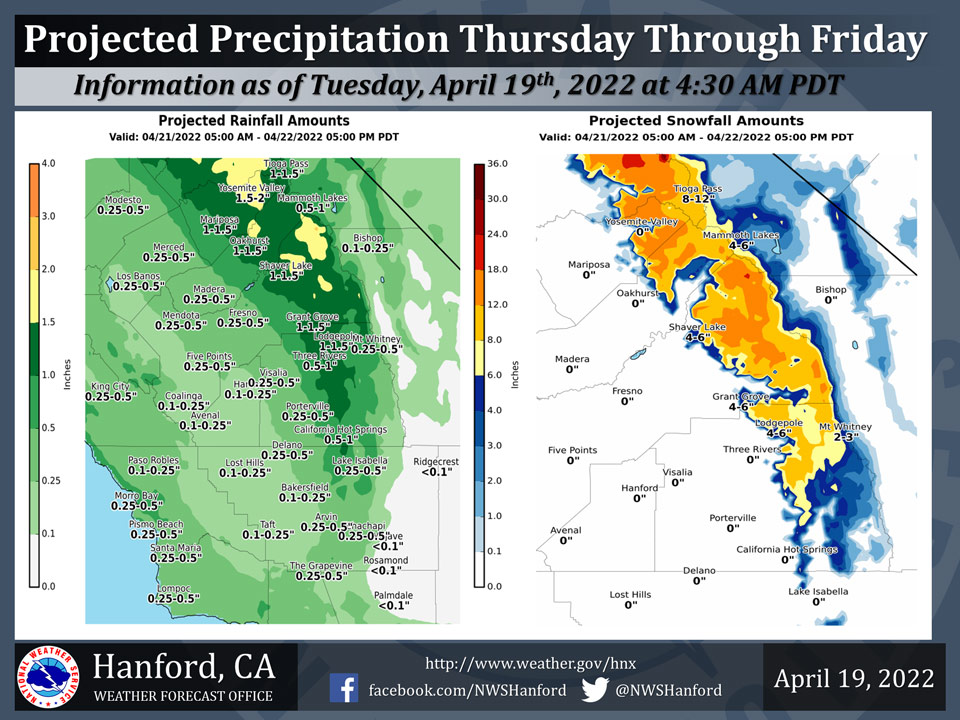
Projected Precipitation for Mariposa 1.00" - 1.50"
Projected Precipitation for Oakhurst 0.50" - 1.00" 1.00"- 1.50"
Projected Precipitation for Yosemite Valley 1.00" - 1.50" 1.50"- 2.00"
April 19, 2022 - The National Weather Service Hanford Office reports a storm system is expected to produce significant precipitation across most of Central California Thursday through Friday.Snow levels will start around 6,000 feet Thursday, before dropping to about 5,000 feet by Friday morning.
Up to 18 inches of snow is possible across the higher elevations of the Sierra Nevada north of Kings Canyon NP.
The majority of this precipitation will fall Thursday afternoon through Thursday night.
  Area Forecast Discussion
  National Weather Service Hanford CA
  336 AM PDT Tue Apr 19 2022

  .SYNOPSIS...A weak system will bring a chance of light
  precipitation from Fresno County northward today. Gusty winds are
  likely in the Kern County Deserts through this evening. A
  stronger storm system will impact Central California Thursday and
  Friday, resulting in widespread precipitation, cooler than normal
  temperatures and gusty winds. High pressure will bring dry
  conditions and a warming trend over the weekend.

  &&

  .DISCUSSION...Pacific frontal system currently pushing through
  Norcal this morning. SREF indicating this system will push into
  central CA later this morning and bring some light precipitation
  from Fresno County northward through early this afternoon. QPF
  progs are trending lower with a tenth to a quarter inch of liquid
  precipitation expected for the Yosemite Park area with up to a
  tenth of an inch further south to Kings Canyon. A few hundredths
  of an inch of rain are possible in Merced County today southward
  to Madera and northern Fresno Counties. The snow level is
  expected to be around 7000 feet and an inch or two of snow is not
  out of the question today for higher elevations in Yosemite Park.
  Measurable precipitation is not anticipated south of Fresno County
  with this system. Another impact from this system will be a
  period of gusty winds over the Kern County Desert areas from later
  this morning through this evening. Gusts up to 55 mph will be
  possible along the Mojave Desert Slopes and a Wind Advisory is in
  effect for the Kern County Desert areas through this evening.

  Shortwave ridging moves into central CA for tonight and Wednesday
  which will provide for a period of dry weather and allow for a
  slight recovery in temperatures with slightly above normal
  daytime readings expected.

  The SREF is in good agreement with previous NBM runs in showing a
  fairly strong upper low approaching Norcal Wednesday night and
  brings a moist upper trough through CA Thursday morning through
  Friday afternoon. This system will bring widespread precipitation
  to our area along with cooler than normal temperatures along with
  a period of gusty winds across the mountains and deserts of Kern
  County. Precipitation is expected to spread southward into our
  area by Thursday morning with the bulk of the precipitation
  expected Thursday afternoon through Thursday night. Latest NAM
  progs are showing instability and CAPE will be sufficient enough
  for at least a slight chance of thunderstorms across much of our
  area by Thursday evening. QPF progs are indicating 0.75 to 1.5
  inches of liquid precipitation across much of the Sierra Nevada
  and adjacent foothills with the snow level between 6500 and 7000
  feet on Thursday lowering to around 5000 feet on Friday with a
  chance of post-frontal showers continuing over the area. One to
  two feet of snow are anticiapted over the Sierra Nevada north of
  Kings Canyon above 7000 feet while 8 to 16 inches are possible
  above 7000 feet further south in Tulare County. Most of the San
  Joaquin Valley and the Kern County Mountains can expected between
  quarter and a half inch of rainfall. With the snow level expected
  to remain above pass levels in Kern County, we are not
  anticipating any adverse impacts over the major passes in Kern
  County aside from gusty winds as times. A chance of post-frontal
  showers exists for nearly our entire are on Friday before the
  trough moves to the east of our area by Friday night.

  Medium range models and their ensemble members are in fairly good
  agreement with building a fairly strong upper ridge into CA over
  the weekend which will provide for dry weather along with a
  noticable warming trend. The ridge is progged to strengthen early
  next week resulting in daytime high temperatures of 10-13 Deg F
  above climatological normals next Monday and Tuesday.

  &&

  .AVIATION...Areas of MVFR conditions with local mountain
  obscuring IFR in the Sierra Nevada from Fresno County northward
  through 24Z today. Otherwise, VFR conditions will prevail across
  the Central CA interior for at least the next 24 hours.

  &&

  .AIR QUALITY ISSUES...None.
Source: NWS
