


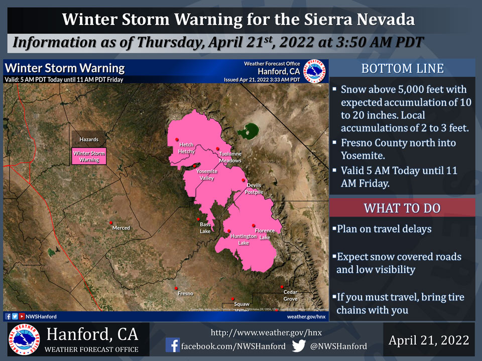
April 21, 2022 - The National Weather Service Hanford Office reports a Winter Storm Warning is in effect for the Sierra Nevada from Fresno County northward into Yosemite National Park above 5,000 feet from 5:00 A.M. today through 11:00 A.M. Friday.
The majority of this snow is expected to fall in the afternoon and evening.
If you plan to travel, consider alternate strategies. If you must travel, remember to carry tire chains, plenty of food, a good deal of water, warm clothing, and a flashlight in your vehicle.
For information on road conditions, including closures or delays, call Caltrans at 1-800-427-7623.
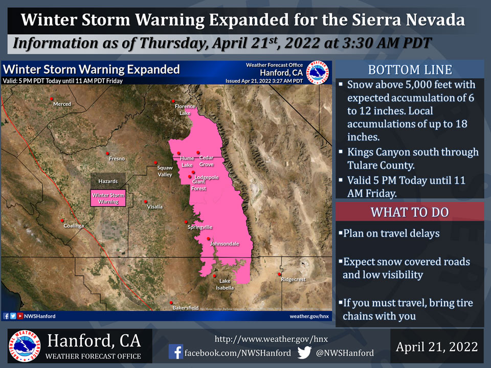
A Winter Storm Warning is in effect for the Sierra Nevada from Kings Canyon National Park southward through Tulare County above 5,000 feet from 5:00 P.M. today through 11:00 A.M. Friday morning. The majority of this snow is expected to fall Thursday afternoon through Friday morning. If you plan to travel, consider alternate strategies. If you must travel, remember to carry tire chains, plenty of food, a good deal of water, warm clothing, and a flashlight in your vehicle. For information on road conditions, including closures or delays, call Caltrans at 1-800-427-7623.
Winter Storm Warning
URGENT - WINTER WEATHER MESSAGE
National Weather Service Hanford CA
300 AM PDT Thu Apr 21 2022


Yosemite NP outside of the valley-Upper San Joaquin River-
Kaiser to Rodgers Ridge-
Including the cities of Tuolumne Meadows, Wawona,
Devils Postpile, Florence Lake, Lake Thomas Edison, Lake Wishon,
Huntington Lake, and Shaver Lake
300 AM PDT Thu Apr 21 2022

...WINTER STORM WARNING REMAINS IN EFFECT UNTIL 11 AM PDT FRIDAY
ABOVE 5000 FEET...

* WHAT...Heavy snow above 5000 feet. Total snow accumulations of
  10 to 20 inches. Localized amounts of 2 feet or more over higher
  elevations. Winds gusting as high as 60 mph.

* WHERE...Sierra Nevada above 5000 feet from Yosemite NP to Kings
  Canyon NP.

* WHEN...From 5 AM Thursday to 11 AM PDT Friday.

* IMPACTS...Travel could be very difficult to impossible.

PRECAUTIONARY/PREPAREDNESS ACTIONS...

If you must travel, keep an extra flashlight, food, and water in
your vehicle in case of an emergency.

The latest road conditions for the state you are calling from can
be obtained by calling 5 1 1.
Winter Storm Warning
URGENT - WINTER WEATHER MESSAGE
National Weather Service Hanford CA
300 AM PDT Thu Apr 21 2022


South End of the Upper Sierra-
Including the city of Johnsondale
300 AM PDT Thu Apr 21 2022

...WINTER STORM WARNING IN EFFECT FROM 5 PM THIS AFTERNOON TO
11 AM PDT FRIDAY ABOVE 5000 FEET...

* WHAT...Heavy snow above 5000 feet. Total snow accumulations of
  6 to 12 inches. Localized amounts up to 18 inches over higher
  elevations. Winds gusting as high as 60 mph.

* WHERE...South End of the Upper Sierra above 5000 feet.

* WHEN...From 5 PM this afternoon to 11 AM PDT Friday.

* IMPACTS...Travel could be very difficult to impossible.

* ADDITIONAL DETAILS...

PRECAUTIONARY/PREPAREDNESS ACTIONS...

If you must travel, keep an extra flashlight, food, and water in
your vehicle in case of an emergency.

The latest road conditions for the state you are calling from can
be obtained by calling 5 1 1.
Source: NWS
