


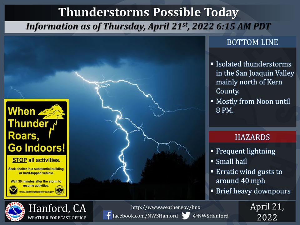
April 21, 2022 - The National Weather Service Hanford Office reports thunderstorms will likely develop over the San Joaquin Valley this afternoon and early evening.
In addition to dangerous cloud to ground lightning, a few thunderstorms may bring heavy rain, small hail, and wind gusts to about 40 mph.
  Area Forecast Discussion
  National Weather Service Hanford CA
  452 AM PDT Thu Apr 21 2022


  .SYNOPSIS...
  A storm system will impact the area today and Friday, bringing
  valley rain, mountain snow, gusty winds and cooler temperatures.
  There is also a slight chance of thunderstorms this afternoon and
  evening. Dry weather along with a warming trend are expected this
  weekend into early next week.

  &&

  .DISCUSSION...
  Satellite imagery shows a large upper level low spinning over the
  northeast Pacific that is poised to bring a period of winter-like
  weather to the central California interior over the next 36 hours.
  Radar imagery shows a band of light to moderate precipitation from
  the Monterey Bay area northeast towards Lake Tahoe. This band will
  begin to affect the district by sunrise with light rain moving into
  Merced and Mariposa Counties and snow over the high Sierra around
  Yosemite NP. The snow level will begin around 6500 feet then lower
  to around 4500 by Friday morning. Latest hi-res modeling suggests
  the precipitation band will stall out around Fresno County today
  before progressing south this evening. Have adjusted the timing of
  the Winter Storm Warning to account for the later arrival of precip
  for areas farther south. The Warning will still begin at 5am for
  areas above 5000 feet from Yosemite NP to Kings Canyon NP, where
  snow accumulations of 10 to 20 inches with local amounts of 2 feet
  or more over higher elevations are expected. The Warning for the
  Grant Grove area, Kings Canyon NP and Sequoia NP has been pushed
  back to begin at 5pm now and have added the south end of the upper
  Sierra as well. Snow accumulations of 6 to 12 inches and localized
  amounts of 18 inches or more are expected. The Warnings all expire
  at 11am on Friday. Rainfall amounts for the San Joaquin Valley are
  expected to be quite variable with higher amounts to the north and
  east side of the valley ranging from one quarter to three quarters
  of an inch. Lower amounts generally for the south end and west side
  of the valley due to rain shadowing effects, ranging from one tenth
  to one quarter of an inch. Rain amounts along the Sierra foothills
  are expected to range from three quarters to one and one half of an
  inch. The Kern County mountains are generally expected to receive
  one quarter to one half of an inch. The Kern County Desert will be
  rain shadowed as usual with only a few hundredths to one tenth of
  an inch expected. The combination of daytime heating and colder air
  aloft will increase instability this afternoon for the potential of
  thunderstorms. In addition to lightning, storms will be capable of
  producing small hail, strong wind gusts, and brief heavy rainfall.
  The system will shift east of the region on Friday with diminishing
  showers through the afternoon then dry conditions by the evening.
  Strong wind gusts will develop in the Kern County mountain passes
  and into the desert today where a Wind Advisory has been issued from
  11am this morning until 8pm this evening. Stronger winds may develop
  along the Mojave Desert Slopes on Friday.

  Temperatures today are forecast to be around 5 to 10 degrees below
  climatological normals. Friday will be the coolest day with highs
  around 10 to 15 degrees below normal. High pressure will begin to
  build in this weekend with highs warming to slightly below normal
  on Saturday then slightly above normal on Sunday. By Monday, highs
  are forecast to be around 7 to 12 degrees above normal. The ridge
  flattens Tuesday and Wednesday with a little cooling expected but
  still above normal temperatures.

  &&

  .AVIATION...VFR conditions will prevail across the Central CA
  Interior until 12Z Thursday. A storm will begin impacting the
  Central CA Interior after 12Z Thursday as Rain and Snow enters
  the region. MVFR conditions will dominate the region after 18Z
  with local IFR conditions in mountain obscurations from Yosemite
  to Kings Canyon.

  &&

  .AIR QUALITY ISSUES...
  None.
Source: NWS
