


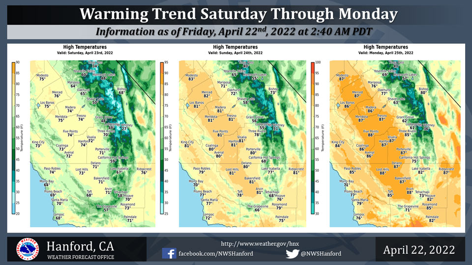
Mariposa Projected High Temperatures for Saturday through Monday: 64-76 Degrees
Oakhurst Projected High Temperatures for Saturday through Monday: 65-77 Degrees
Yosemite Valley Projected High Temperatures for Saturday through Monday: 60-69 Degrees
April 22, 2022 - The National Weather Service Hanford Office reports high temperatures throughout Central California Saturday afternoon will be six to eight degrees warmer than this afternoon.
Maximum temperatures across Central California Sunday afternoon will be six to eight degrees warmer than Saturday afternoon.
By Monday afternoon, high temperatures throughout Central California will be around ten degrees above normal for this time of year.
  Area Forecast Discussion
  National Weather Service Hanford CA
  331 AM PDT Fri Apr 22 2022


  .SYNOPSIS...
  Precipitation will come to an end by this morning, with high
  temperatures remaining up to 10 degrees below average. Strong
  winds will become likely by the afternoon along the Mojave desert
  slopes. High pressure then returns to the area by the weekend
  through next week, bringing dry weather as well as increasing
  temperatures back above average.


  &&

  .DISCUSSION...
  As of 3 AM PDT, isolated showers continue across the valley with
  rain and snow showers above 5,000 feet over portions of the Sierra
  and Kern County mountains. Water vapor imagery shows that the
  main trough axis is currently swinging through the central
  California interior with a secondary circulation moving into the
  central CA coast. High-resolution models indicate that rain and
  snow showers will continue into mid-morning as the trough exits
  the area. Additional precipitation amounts of 1/4 to 1/2 inches is
  likely in the Sierra and Kern Mountains with additional snow
  amounts of 3 to 6 inches. The Winter Storm Warning for the Sierra
  will remain in effect until 11 AM PDT. Temperatures today will be
  6 to 10 degrees below average across the district, with most of
  the valley and desert remaining in the 60s.

  As the trough exits the area, strong winds will develop along the
  Mojave desert slopes by late morning through the evening. High-
  resolution models indicate that surface pressure gradients between
  SFO-LAS will increase between 10-13mb along with a 80-90kt jet at
  500mb. Sustained northwest winds of 25 to 35 mph with gusts to 55
  mph are likely, creating hazardous travel conditions through and
  below Tehachapi Pass, Walker Pass, and Highway 14. A Wind Advisory
  has been issued for this area through 11 PM PDT tonight.

  After this system exits the area later tonight, a high pressure
  ridge will build over the western US through Tuesday morning.
  Temperatures will increase between 4 to 8 degrees on Saturday and
  an additional 4 to 8 degrees on Sunday, once again hitting the low
  80s in the valley and desert. We`ll warm an additional 4 to 8
  degrees on Monday, with many locations over the central California
  interior ending up 4 to 8 degrees above average for late April.
  This high pressure ridge flattens out by Tuesday through the end
  of the forecast period Friday, with temperatures returning to near
  average. Dry weather will return this weekend and will persist
  through next week.


  &&


  .AVIATION...MVFR conditions will persist throughout the region
  through 18z Friday with local IFR conditions in mountain
  obscurations in the Sierra and Kern Mountains. VFR conditions
  after 18z Friday in the San Joaquin Valley with mountain
  obscuration possible until 0z Saturday. Strong northwest winds of
  20 to 30 kts with gusts to 50 kts are likely through and below the
  Kern mountains.

  &&

  .AIR QUALITY ISSUES...
  None.
Source; NWS
