


California and National Drought Summary for April 26, 2022
Summary
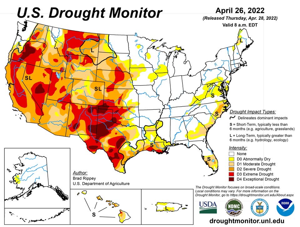
April 28, 2022 - Only about 10 days after a powerful, winter-like storm struck the northern Plains, a similar system delivered another round of heavy precipitation and high winds. With the more recent storm, which primarily unfolded on April 22-23, heavy snow was focused across a smaller area, primarily blanketing western North Dakota, southeastern Montana, northwestern South Dakota, and portions of Wyoming. Meanwhile in the Red River Valley, heavy rain falling on partially frozen soils resulted in extensive flooding, especially north of Fargo, North Dakota, with runoff further enhanced by melting snow. Farther south, high winds again raked the central and southern Plains and the Southwest, resulting in blowing dust and fast-spreading wildfires. Across the southern High Plains’ hardest-hit drought areas, hot, windy weather sapped any remaining soil moisture and further stressed rangeland, pastures, and winter grains. Meanwhile, a few severe thunderstorms dotted the Plains and upper Midwest, leading to localized wind and hail damage. The greatest concentration of severe weather occurred on April 22 from South Dakota to northern Texas. In contrast, little or no precipitation fell during the week across the nation’s southwestern quadrant, leading to further drought intensification. As the drought-monitoring period ended (on the morning of April 26), a significant rain event was winding down across parts of southern and eastern Texas.
Northeast
With a cool, mostly dry weather pattern in place, there were no changes to the Northeastern drought depiction. Small areas of moderate drought (D1) existed in Maine, Maryland, and West Virginia, but much of the region was free of dryness and drought. In drought-affected areas, concerns included low streamflow and groundwater shortages.
Southeast
Generally dry weather prevailed during the drought-monitoring period. As a result, there were some slight increases in the coverage of abnormal dryness (D0) and moderate to severe drought (D1 to D2) from Florida to North Carolina. On April 24, Florida led the region with topsoil moisture rated 38% very short to short, followed by Georgia at 31%, according to the U.S. Department of Agriculture. On the same date, 22% of Florida’s pastures were rated in very poor to poor condition.
South
The region remained split between critically dry conditions on the High Plains of Oklahoma and Texas and wet conditions just to the east. During the drought-monitoring period, the axis of heaviest rain stretched from northeastern Texas into northern Arkansas, with additional rainfall maxima in parts of southern and eastern Texas. Those rains led to targeted, one-category improvements in the drought depiction, with highly localized two-category changes. Meanwhile, the region’s driest areas continued to experience deteriorating conditions, including a broad expansion of exceptional drought (D4), amid periods of extreme heat, high winds, and blowing dust. Temperatures reached 100°F—mainly on April 20 and 21—in parts of the south-central U.S., extending to the Texas-Oklahoma border near Childress (100°F on April 21) and Wichita Falls, Texas (99°F on April 20). In western Texas, peak gusts April 22 were clocked to 73 mph in Lubbock and Dalhart. On April 24, Texas led the country in several drought-related categories, according to the U.S. Department of Agriculture, including topsoil moisture rated very short to short (86%, tied with New Mexico) and winter wheat rated in very poor to poor condition (78%). On the same date, nearly half (48%) of Oklahoma’s wheat was rated very poor to poor.
Midwest
Widespread precipitation, accompanied by cool conditions, led to general reductions in the coverage of abnormal dryness (D0) and moderate drought (D1). In fact, a pesky area of D1, stretching across portions of eastern Iowa, northern Illinois, and southern Wisconsin, was finally eliminated by soaking rainfall. Drought (D1) was also completely removed from northern Minnesota, following another round of heavy precipitation. Daily-record rainfall amounts included 1.16 inches (on April 22) in Rockford, Illinois, and 1.49 inches (on April 23) in International Falls, Minnesota. By April 24, topsoil moisture was rated one-quarter to one-half surplus in all Midwestern States except Iowa, led by Illinois (49% surplus), according to the U.S. Department of Agriculture. In addition, only 7% of the intended U.S. corn acreage had been planted by April 24, the least amount sown on that date since 2013. Corn seeding was at least 10 percentage points behind the 5-year average planting pace in Illinois, Iowa, Kentucky, Minnesota, and Missouri. Cold weather was a factor in the slow planting place, along with wet conditions. On the morning of April 26, daily-record low temperatures in Iowa included 19°F in Sioux City and 22°F in Cedar Rapids.
High Plains
For the second week in a row, significant precipitation fell across parts of the northern Plains. Heavy snow blanketed western North Dakota, southeastern Montana, northwestern South Dakota, and parts of Wyoming, helping to further improve soil moisture. Still, by April 24, the U.S. Department of Agriculture reported topsoil moisture was rated at least one-half very short to short in each of the region’s states except North Dakota (26% very short to short, down from 39% the previous week). Elsewhere in the region, topsoil moisture rated very short to short ranged from 53% in South Dakota to 82% in Nebraska. Still, parts of the eastern Dakotas have become very wet, with runoff enhanced by melting snow and rain falling on partially frozen soils. Following the latest storm, moderate to major flooding developed in the Red River Valley, extending northward from near Grand Forks, North Dakota. By April 27, the Red River at Oslo, Minnesota, was more than 11.5 feet above flood stage and less 10 inches below the April 2009 high-water mark. Farther south, however, drought continued to gradually expand and intensity, amid windy, mostly dry conditions and rapid temperature fluctuations. In Nebraska, daily-record highs for April 22 soared to 91°F in Sidney and 97°F in Valentine and North Platte, followed just 3 days later by a daily-record low of 14°F in Sidney. By April 24, more than one-quarter of the winter wheat in each of the region’s major production states was rated in very poor to poor condition, led by Colorado (47%) and Kansas (36%).
West
Conditions were nearly identical those observed the previous week, with beneficial precipitation falling across the northern tier of the region and windy, dry weather dominating the Southwest. Given the Southwest’s low humidity levels, high winds, and drought-cured vegetation, two active wildfires—the Hermits Peak and Cooks Peak Fires—charred more than 50,000 acres of vegetation apiece in northeastern New Mexico. Northeast of Flagstaff, Arizona, the Tunnel Fire—ignited on April 17—scorched nearly 20,000 acres of vegetation and destroyed more than 50 structures. At times, impressively high winds raked the Southwest, raising dust and fanning flames. On April 22 in New Mexico, wind gusts in Gallup, Farmington, Las Vegas, and Raton were clocked to 70, 72, 73, and 80 mph, respectively. By April 24, according to the U.S. Department of Agriculture, New Mexico led the nation—tied with Texas—with topsoil moisture rated 86% very short to short. By the 26th, Tucson, Arizona, reported a daily-record high of 100°F—only the fourteenth observance of triple-digit heat on record during April in that location. Tucson’s only earlier readings of 100°F or higher occurred on April 19-21, 1989, and April 22-23, 2012. Deterioration was common across the Southwest, with extreme to exceptional drought (D3 to D4) broadly expanding in New Mexico and moderate to severe drought (D1 to D2) increasing in coverage across parts of Arizona and Colorado. Farther north, however, periods of precipitation continued from northern California and the Pacific Northwest to the northern Rockies. Changes in the Northwestern drought depiction, although fewer than those noted the previous week, were driven by factors such as improving water-supply prospects and increasing topsoil moisture. In Oregon, topsoil moisture rated very short to short improved from 47 to 36% during the week ending April 24.
Caribbean
In Puerto Rico, locally heavy showers resulted in a slight reduction in the coverage of abnormal dryness (D0) and moderate drought (D1). However, D0 persisted along Puerto Rico’s northwestern coast, while D0 and D1 continued across portions of the southern slopes and coastal areas.
In summary, showers brought some rain to the U.S. Virgin Islands (USVI) this week, but rainfall totals were below weekly normals. Radar-based estimates (QPE) of weekly rainfall showed widespread rain across Puerto Rico but only a few pockets of rain over the USVI, specifically half an inch or less over parts of St. Thomas and St. John and a fourth of an inch or less over western and southern parts of St. Croix. Groundwater levels continued to decline on all three islands and there were reports of low cisterns. With the lack of soaking rains, moderate drought continued on St. John and St. Thomas and severe drought continued on St. Croix.
Weekly rain gauge totals on St. John ranged from 0.44 inch to 0.68 inch. The 0.44 inch at Windswept Beach was below the long-term average for the week of 0.64 inch, and the monthly total of 1.23 inches is 52% of the long-term average for the month-to-date. Standardized Precipitation Index (SPI) values support drought at the long-term time scales. The groundwater level at the USGS Susannaberg DPW 3 Well on St. John continued to decline this week and has steadily declined since early February. It is at the lowest level since 2017. D1-SL continued for St. John.
On St. Thomas, weekly rain gauge totals ranged from 0.28 inch to 0.44 inch. The weekly total of 0.41 inch at King AP was below normal, and the 1.47 inches for the month so far was 82% of normal. The SPI values support drought at the long-term time scales, but not at the short-term time scales. The groundwater level at the USGS Grade School 3 Well on St. Thomas continued to decline this week and has steadily declined since early February. D1-L continued for St. Thomas.
St. Croix was the driest island of the three this week, with weekly rain gauge totals ranging from zero to 0.34 inch, and most about a tenth of an inch or less. Rohlsen AP and East Hill both reported no measurable rain this week. The April-to-date total of 0.25 inch at Rohlsen AP was 14% of normal for the month and sixth driest out of 63 years, and the 0.53 inch at East Hill was 29% of normal and sixth driest out of 48 years. Rohlsen AP has received 25.71 inches for the last 12 months (4/27/2021-4/26/2022), which ranks as eighth driest out of 62 years for comparable 12-month periods. The SPI values at Rohlsen AP and East Hill support significant drought at both the 1-month and 9- to 12-month time scales. The groundwater level at the USGS Adventure 28 Well on St. Croix continued to decline this week and has steadily declined for the past year. It is at the lowest level in the 2016-2022 record. Reports have been received of cracked soil and dry vegetation, with the “hot, dry, windy” weather causing distress for local farmers. D2-SL continued for St. Croix.
Pacific
Abnormal dryness (D0) was introduced in a small area of southwestern Alaska, including low elevations of the lower Yukon-Kuskokwim region, where the spring has been dry and relatively warm. In addition, an unusually high percentage of the region’s winter precipitation fell as rain, rather than snow, leading to early elimination of low-elevation snowpack. In recent days, the Kwethluk Fire burned across nearly 10,000 acres of tundra in the Yukon Delta National Wildlife Refuge. Although spring fires in this region are not unusual, the Kwethluk Fire is Alaska’s largest April wildfire in at least the last 30 years.
In Hawaii, a tight gradient persisted between locally heavy showers in windward locations and dry weather on most leeward slopes. A bit of abnormal dryness (D0) was erased from windward sections of Molokai and Maui; otherwise, there were no changes. Through April 26, month-to-date rainfall at Hawaii’s major airport observation sites ranged from 0.04 inch (6% of normal) in Honolulu, Oahu, to 15.03 inches (179%) in Hilo, on the Big Island. Hilo reported measurable rain each day from March 28 to April 26, a 30-day streak.
Rain associated with the Inter-Tropical Convergence Zone (ITCZ) and trade-wind troughs brought a wet week to much of Micronesia, stretching from Palau, across the Federated States of Micronesia (FSM), to southern parts of the Marshall Islands (RMI). An upper-level low gave the northern RMI some rain. The ITCZ rains missed some southern parts of the FSM, while a dry trade-wind pattern dominated the Marianas. South of the equator, American Samoa was caught between a dry ridge to the north and a showery South Pacific Convergence Zone (SPCZ) to the south. As a result of this mix of weather features, the drought status did not change across the USAPI this week. Severe drought continued in the northern RMI and abnormal dryness continued at Kapingamarangi, with no drought or abnormal dryness at the rest of the USAPI stations.
In the Marianas, weekly rainfall totals ranged from 0.27 inch at the Saipan ASOS station to 0.84 inch at Guam. These values are below the weekly minimum required to meet most water needs, which is one inch for the Marianas. However, rainfall from earlier in the month gave Guam, Saipan, and Rota a wet April (above the 4-inch monthly minimum required to meet most water needs), so D-Nothing continued.
Over 4 inches of rain fell this week in Palau at Airai (4.53 inches) and Koror COOP (7.59), with month-to-date April totals over 15 inches at both stations. D-Nothing continued for Palau.
SPCZ showers gave the automated station at Toa Ridge 1.53 inches of rain this week and 1.41 inches at Pago Pago, which are above the 1-inch weekly minimum for American Samoa, but only 0.64 inch at Siufaga Ridge. Wet conditions during earlier weeks supported the continuation of D-Nothing for Tutuila.
In the FSM, Yap reported 0.95 inch of rain for the week and Kapingamarangi 1.31 inches. The rest of the regular-reporting stations were wet (above the 2-inch weekly minimum for the FSM), with weekly rainfall totals ranging from 2.28 inches at Chuuk to 6.30 inches at Nukuoro. April-to-date was dry at Kapingamarangi (5.15 inches so far, which is below the monthly to-date minimum), so D0-S continued. Month-to-date rainfall totals for April were wet at the rest of the FSM stations, so D-Nothing continued, except for Fananu which could not be analyzed due to lack of data.
In the RMI, Utirik could not be analyzed due to lack of data. Less than half an inch of rain fell across parts of the northern islands, with Wotje recording 0.42 inch, which is less than the 2-inch weekly minimum for the Marshalls. April-to-date (4.76 inches) is dry, so D2-SL continued for Wotje. Jaluit reported 0.70 inch, but that was based on only 3 days of data, and Kwajalein reported 1.42 inches, which is dry for the week, but Ailinglaplap, Majuro, and Mili were wet, with weekly totals ranging from 5.61 inches to 7.94 inches. All of these stations were wet for the month, so D-Nothing continued for them.
Looking Ahead
The threat of frost and sub-freezing temperatures will linger at least into Friday in parts of the Great Lakes and Northeastern States. Meanwhile, a disorganized storm system will cross the western U.S. before intensifying on April 29-30 over the nation’s mid-section. With the storm’s path across the central Plains and upper Midwest, rainfall could reach 1 to 3 inches in the north-central U.S., with some of the highest amounts expected on Friday in the Dakotas. Meanwhile, windy, dry weather in the nation’s southwestern quadrant will lead to additional drought and wildfire concerns. Late in the weekend, however, portions of the southern Plains may experience some drought relief.
The NWS 6- to 10-day outlook for May 3 – 7 calls for the likelihood of near- or below-normal temperatures across the North and Far West, while warmer-than-normal weather will prevail from the Four Corners States eastward to the middle and southern Atlantic Coast. Meanwhile, near- or above-normal precipitation across most of the country should contrast with drier-than-normal conditions in the upper Great Lakes region and parts of the Southwest.
Author(s):
Brad Rippey, U.S. Department of Agriculture
Richard Heim, NOAA/NCEI
Dryness Categories
D0 Abnormally Dry—used for areas showing dryness but not yet in drought, or for areas recovering from drought.
Drought Intensity Categories
D1 Moderate Drought
D2 Severe Drought
D3 Extreme Drought
D4 Exceptional Drought
Drought or Dryness Types
S Short-term, typically less than 6 months (agriculture, grasslands)
L Long-term, typically more than 6 months (hydrology, ecology)
SL Area contains both short- and long-term impacts
Source: National Drought Mitigation Center
