


Mariposa projected high temperature for Wednesday: 82 degrees, Thursday: 83 degrees
Oakhurst projected high temperature for Wednesday: 83 degrees, Thursday: 84 degrees
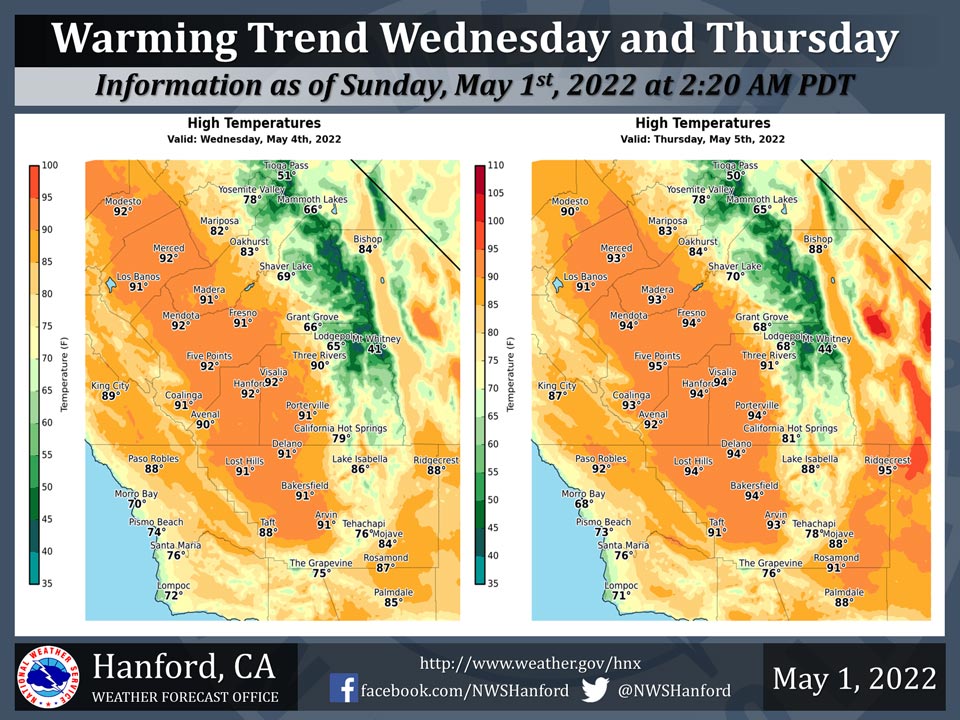
Yosemite Valley projected high temperature for Wednesday: 78 degrees, Thursday: 78 degreesMay 1, 2022 - The National Weather Service Hanford Office reports high temperatures throughout Central California Wednesday afternoon will be around ten degrees warmer than Tuesday afternoon.
By Thursday afternoon, maximum temperatures across Central California will be twelve to fourteen degrees above normal for this time of year.
  Area Forecast Discussion
  National Weather Service Hanford CA
  325 AM PDT Sun May 1 2022


  .SYNOPSIS...
  Windy conditions along the Mojave Desert Slopes until Sunday
  Night. A little cooler today as a dry trough enters the Great
  Basin. Much warmer by the middle of next week with dry weather
  expected to continue.

  &&

  .DISCUSSION...
  Disturbance currently crossing the region is producing strong
  westerly winds over portions of Kern County. While the bulk of the
  energy from the disturbances passage is over the Great Basin
  (east of the Central California Interior), a portion of that
  energy is skirting the district. Enough jet-stream energy is
  currently moving across the district to generate wind gusts up to
  50 mph. The strong winds are also getting support from the
  surface. The pressure gradient from KSFO to KLAS was currently at
  12mb and is tight enough to provide for isolated wind gusts
  reaching advisory criteria. Therefore, until the disturbance exits
  the region tonight, will expect strong winds over the eastern
  portions of the Kern County Mountains. Otherwise, temperatures
  will see a slight up and down until mid-week when the area heats-
  up under a much strong ridge pattern.

  Satellite and upper air analysis is showing the disturbance over
  Southeastern Oregon and moving southeast. Confidence in the
  trajectory of the upper disturbance is high as Hi-Res ensemble
  mean upper-air analysis has it moving through the Great Basin
  today. Therefore, winds will be the biggest impacts as the region
  remains dry and temperatures return to near normal conditions.
  Ensemble mean and member consensus is to have the desert winds
  start to drop off after 5 PM PDT. This will coincide with the
  departure of the disturbances energy this evening as the advisory
  is expected to expire around 11 PM PDT.

  Once the disturbance exits the region, weak ridge will move
  through the region ahead of another disturbance following a
  similar path. While uncertainty is a bit higher on the possible
  trajectory of the second disturbance, will lean toward a Great
  Basin path. This will then allow for another strong wind event.
  Monday will see slight warming of temperatures with winds
  beginning to feel the effects of the next disturbance. Between
  Monday and Tuesday, the ridge exits and another trough moves
  through the region. Consensus among the ensemble members is high
  that similar winds will be observed on Monday and Tuesday to those
  currently occurring. Yet, the district will remain dry during the
  next disturbance along with minor temperature changes.

  The second disturbance is projected to exit the region later on
  Tuesday. At which time, winds will drop off and cooler conditions
  are felt. Ensemble cluster analysis shows a different story by
  mid-week as a strong signal points to a well defined ridge
  pattern. With only minor differences on possible ridge solutions,
  will expected good warming to occur as valley temperature reach
  into the 90 degree mark. While probability of exceedance is only
  around 50 percent of reaching the 90 degree mark on Wednesday,
  that percentage grows to just over 70 percent on Thursday.
  Therefore, the heat is on by mid-week before yet another
  disturbance provides another wave of cooling.

  &&

  .AVIATION...
  Surface winds gusting to 45 knots across the Mojave Desert Slopes
  in eastern Kern County until 06Z Monday. Otherwise, VFR
  conditions will prevail throughout Central California for at least
  the next 24 hours.

  &&

  .AIR QUALITY ISSUES...
  None.
Source; NWS
