


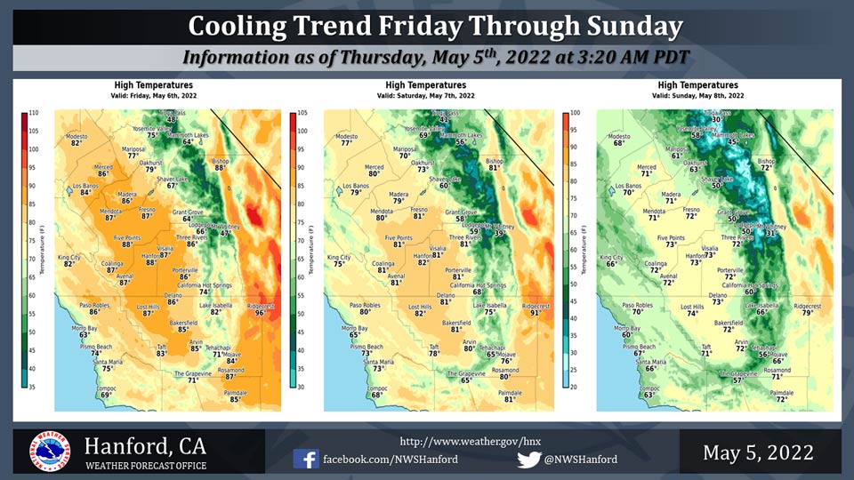
Mariposa projected high temperature for Friday: 77 degrees, Saturday: 70 degrees, Sunday: 61 degrees
Oakhurst projected high temperature for Friday: 79 degrees, Saturday: 73 degrees, Sunday: 63 degrees
Yosemite Valley projected high temperature for Friday: 75 degrees, Saturday: 69 degrees, Sunday: 58 degrees
May 5, 2022 - The National Weather Service Hanford Office reports maximum temperatures throughout Central California Friday afternoon will be three to five degrees lower than this afternoon.
High temperatures across Central California Saturday afternoon will be about five degrees cooler than Friday afternoon.
By Sunday afternoon, maximum temperatures throughout Central California will be around ten degrees below normal for this time of year.
  Area Forecast Discussion
  National Weather Service Hanford CA
  300 AM PDT Thu May 5 2022


  .SYNOPSIS...
  Temperatures will remain above normal through Friday. A cooling
  trend will then take place with temperatures lowering to near
  normal by Saturday and then below normal through the middle of
  next week. Gusty winds are possible over the weekend and light
  precipitation is possible in the Sierra Nevada by Monday.

  &&

  .DISCUSSION...
  Upper ridge pattern will dominate the West Coast for one more day
  as warm temperatures will be observed this afternoon. The San
  Joaquin Valley was able to reach the 90 degree mark on Wednesday
  as the ridge axis was overhead. While upper air analysis is
  showing the ridge axis slowly shifting east today, enough
  lingering heat will allow for one more day of well above normal
  temperatures. Yet, probability of exceedance for 90 degree over
  above temperatures is only reach the 50 to 60 percent mark for
  areas from Fresno County southward. Therefore, areas in Merced and
  possibly Madera Counties may struggle to reach the 90 degree mark
  today. As for winds, under a ridge, surface pressure gradients
  remain at relax values and have been bouncing around 1mb to 2mb on
  Wednesday and overnight. Breezy winds could develop over portions
  of Kern County, yet, remain below advisory criteria. A
  disturbance is poised to push across the Pacific Northwest today
  and introduce the Central California Interior to strong
  westerlies. While this pattern will affect Central Californias
  temperatures, uncertainty exist on any potential precipitation
  event reaching the district.

  Hi-Res ensemble mean upper air analysis is in good agreement with
  the expected pattern development of having a disturbance cross
  the Pacific Northwest. Main impact over Central California will be
  a return to cooler conditions as the passage of the disturbance
  introduces a zonal flow pattern across the region. While Hi-Res
  ensemble shows some strong winds spreading into the northern
  portions of the Central California, will not expect the strong
  winds to reach down into Kern County. Yet, breezy winds may
  develop today over the higher terrain as even the Kern County
  Mountains could see 15 to 25 mph gusts this afternoon. However,
  the lack of surface support due to a weak surface pressure
  gradient may keep the stronger winds over the mountains and reduce
  the threat of advisory level winds. Ensemble solution then shows
  minimal change going into Friday. Saturday will see significant
  change in the forecast as a piece of energy digs deeper in to
  California and introduces much colder air into the region.
  However, the colder air will only lower temperatures back to near
  normal values.

  Further out in the forecast range, ensemble clustering analysis
  shows a signal toward a disturbance digging through the region
  early next week. While the signal does lean in the direction of
  significant cold air reaching the district, will lean toward the
  mean value range. Therefore, colder than normal along with
  precipitation possibilities around the Monday and Tuesday period.
  Yet, based on cluster precip accumulation analysis, will confine
  the precipitation to mountainous areas and other areas show very
  minimal chances of precipitation. Uncertainty in a possible
  solution for Wednesday is high, yet, may see lingering effects of
  the earlier storm.

  &&

  .AVIATION...
  VFR conditions will prevail throughout the Central CA Interior
  for at least the next 24 hours.

  &&

  .AIR QUALITY ISSUES...
  None.
Source: NWS
