


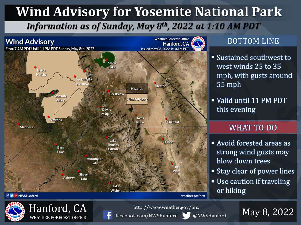
May 8, 2022 - The National Weather Service Hanford Office reports a Wind Advisory is in effect for Yosemite National Park until 11:00 P.M. this evening.
The most intense wind gusts are expected above 8,000 feet.
Strong wind gusts may topple trees, especially those that are dead or weakened by drought or fire.
  Area Forecast Discussion
  National Weather Service Hanford CA
  321 AM PDT Sun May 8 2022


  .SYNOPSIS...
  The district will experience well below average temperatures
  through Wednesday along with chances of precipitation in the
  Sierra each day. Periods of very strong winds will occur in the
  Kern County mountains and desert, and higher elevations of the
  Sierra through Monday. Dry weather will return on Thursday with
  a warming trend expected to increase temperatures into the 90s
  across the San Joaquin Valley next weekend.

  &&

  .DISCUSSION...
  Cool and breezy conditions prevail across the San Joaquin Valley
  tonight with 24 hour trends indicating temperatures are around
  10 degrees lower than this time last night. Stronger wind gusts
  are occurring in the Kern County mountains and into the desert.
  The cause is a strong onshore pressure gradient that is holding at
  around 17mb from SFO-LAS for the last few hours. The gradient is
  expected to tighten a bit more today as additional energy deepens
  the trough over the region. A High Wind Warning is now in effect
  for the Mojave Desert Slopes and the Indian Wells Valley through
  9 AM Monday with gusts up to 75 mph expected. A Wind Advisory is
  still in effect for the remainder of the desert in Kern County as
  well as the southern end of the Sierra and the Tehachapi Mountains
  through 9 AM Monday. There also is a Wind Advisory for Yosemite NP
  outside of the valley from 7 AM this morning to 11 PM this evening.
  Further cooling will result in temperatures around 70 degrees for
  most of the SJ Valley today, around 10 to 12 degrees below average
  for this time of year. Hi-res models show some light precipitation
  possible over the Sierra this afternoon and evening, mainly around
  Yosemite NP but as far south as Kings Canyon NP. Rainfall amounts
  up to one quarter of an inch are possible around Yosemite NP with
  1 to 3 inches of snow possible above 5000 feet.

  The trough will deepen further over the west on Monday resulting
  in a little more cooling. Maximum temperatures are forecast to be
  around 15 degrees below average on Monday and Tuesday with highs
  only in the middle to upper 60s across the SJ Valley. Winds will
  remain breezy with moderately strong gusts in the Kern mountains
  and desert. There is a slight chance for light precipitation for
  the Yosemite NP area on Monday then a better chance develops on
  Tuesday and Wednesday from Yosemite to Sequoia NP.

  Ensembles show good agreement with the trough finally exiting to
  the east on Thursday with high pressure progged to build in from
  the Pacific. Dry weather, lighter winds, and a warming trend are
  forecast from Thursday through next weekend. High temperatures
  are forecast to be back near normal by Friday then above normal
  next weekend.

  &&

  .AVIATION...
  Strong surface winds over 35 knots across the Sierra Nevada and
  the Kern County mountains and desert during the next 24 hours.
  Otherwise, VFR conditions will prevail throughout the Central CA
  Interior for at least the next 24 hours.

  &&

  .AIR QUALITY ISSUES...
  None.
Source: NWS
