


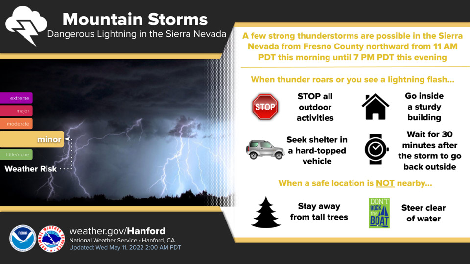
May 11, 2022 - The National Weather Service Hanford Office reports a few strong thunderstorms are possible in the Sierra Nevada from Fresno County northward from 11:00 A.M. this morning until 7:00 P.M. this evening.
Small hail and wind gusts near 45 miles per hour are a couple of hazards associated with strong thunderstorms.
In addition to dangerous cloud to ground lightning strikes, any thunderstorm can produce intense rainfall rates, leading to localized flooding.
  Area Forecast Discussion
  National Weather Service Hanford CA
  1258 AM PDT Wed May 11 2022

  .SYNOPSIS...
  A few strong thunderstorms are possible in the Sierra Nevada from
  Fresno County northward today. Strong, gusty winds are expected in
  the Mojave Desert Slopes today. A warming trend is anticipated
  Thursday through Saturday. High temperatures this weekend will be
  seven to nine degrees above normal for this time of year. A
  cooling trend is expected Monday and Tuesday.

  &&

  .DISCUSSION...
  A cyclone aloft will move southeastward across Central California
  today. This upper-level area of low pressure will weaken as it
  progresses eastward into the Great Basin tonight. A few strong
  thunderstorms are conceivable in the Sierra Nevada from Fresno
  County northward from 11 AM PDT this morning until 6 PM PDT this
  evening. A Wind Advisory is in effect for the Mojave Desert Slopes
  until 8 PM PDT this evening due to west to northwest wind gusts
  near 50 mph. A trough of low pressure over the Eastern Pacific
  Ocean will make landfall along the coast of the Pacific Northwest
  Thursday. This trough of low pressure will progress eastward
  across the Pacific Northwest Thursday night. A ridge of high
  pressure will build northward over the Western United States
  Friday. This ridge of high pressure will amplify over the Western
  United States this weekend. Zonal flow aloft will prevail Monday.
  A weak trough of low pressure may move eastward through Central
  California Tuesday.

  High temperatures this afternoon will be around ten degrees below
  normal for this time of year. A warming trend is expected Thursday
  through Saturday. By Saturday afternoon, maximum temperatures will
  be seven to nine degrees above their typical values for the middle
  of May. High temperatures in the San Joaquin Valley Sunday
  afternoon will be in the lower 90s, which is seven to nine degrees
  above normal for this time of year. Here are probabilities of
  maximum temperatures of 90 degrees or higher for select locations
  in the San Joaquin Valley on Sunday, May 15th, 2022:

  Fresno - 63%
  Hanford - 61%
  Reedley - 61%
  Visalia - 56%
  Lemoore - 52%

  A cooling trend is anticipated Monday and Tuesday. Maximum
  temperatures Monday afternoon will be two to four degrees lower
  than Sunday afternoon. High temperatures Tuesday afternoon will be
  a couple of degrees lower than Monday afternoon. Be that as it
  may, maximum temperatures Tuesday afternoon will be two to four
  degrees above their typical values for the middle of May.

  &&

  .AVIATION...
  Westerly wind gusts up to 45 knots are expected at times over the
  Kern County mountains until 03z this evening. Scattered showers
  and a few thunderstorms over the Sierra Nevada will result in IFR
  or lower conditions this afternoon. VFR conditions will prevail
  throughout Central California tonight into Thursday.

  &&

  .AIR QUALITY ISSUES...
  None.
Source: NWS
