


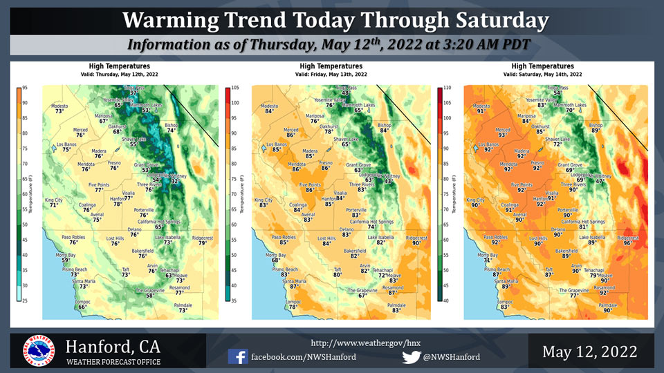
Mariposa projected high temperature for Thursday: 67 degrees, Friday: 76 degrees, Saturday: 84 degrees
Oakhurst projected high temperature for Thursday: 68 degrees, Friday: 78 degrees, Saturday: 85 degrees
Yosemite Valley projected high temperature for Thursday: 65 degrees, Friday: 76 degrees, Saturday: 83 degrees
May 12, 2022 - The National Weather Service Hanford Office reports high temperatures throughout Central California this afternoon will be around five degrees warmer than yesterday afternoon.
Maximum temperatures across Central California Friday afternoon will be about ten degrees warmer than this afternoon.
High temperatures throughout Central California Saturday afternoon will be around five degrees warmer than Friday afternoon.
Maximum temperatures across Central California Saturday afternoon will be eight to ten degrees above normal for this time of year.
Area Forecast Discussion
National Weather Service Hanford CA
145 AM PDT Thu May 12 2022
  .SYNOPSIS...
  A warming trend will occur today through Saturday. High temperatures
  this weekend will be seven to ten degrees above normal for this time
  of the year. A little cooling is expected early next week with highs
  slightly above normal Monday through Wednesday. Generally light winds
  will prevail through Saturday then increasing breezes are likely on
  Sunday. Dry weather is expected through at least the next seven days.

  &&

  .DISCUSSION...
  The upper trough that has been straddling the west coast over the
  last several days has finally pushed to the east over the southern
  Rockies. Behind the trough onshore flow is weakening indicated by
  the SFO-LAS pressure gradient down to 7mb from a high around 13mb
  yesterday. As a result, winds are much lighter than last night at
  this time. 24 hour trends show around 2 to 5 degrees of warming as
  heights begin to rebound behind the departing trough. Temperatures
  will be around five degrees warmer this afternoon with highs about
  four to seven degrees below climatological normals for this time of
  the year. Light zonal flow will develop on Friday with temperatures
  warming up to near normal.

  Ensembles agree with high pressure building in over the weekend for
  continued dry weather and additional warming. Highs are forecast to
  climb into the lower 90s across the San Joaquin Valley on Saturday,
  around seven to ten degrees above normal. The probability of a high
  temperature of 90 degrees or higher on Saturday is 67% for Fresno
  and 25% for Bakersfield. Little changes are expected on Sunday with
  a degree or two of cooling across areas to the north of Fresno and
  a degree or two of warming to the south. The probability of a high
  temperature of 90 degrees or higher on Sunday is 63% for Fresno and
  41% for Bakersfield. The ridge then shifts to the east on Monday as
  an upper trough moves over the Pacific Northwest. Temperatures will
  cool a little but are forecast to remain around two to six degrees
  above normal Monday through Wednesday. Further cooling is possible
  later in the week as cluster analysis is favoring a deepening upper
  trough over the west. Winds will begin to increase again on Sunday
  with windy conditions likely in the Kern County mountains and desert
  at times next week and breezy conditions elsewhere.

  &&

  .AVIATION...
  VFR conditions will prevail throughout Central California for at
  least the next 24 hrs.

  &&

  .AIR QUALITY ISSUES...
  None.
Source: NWS
