


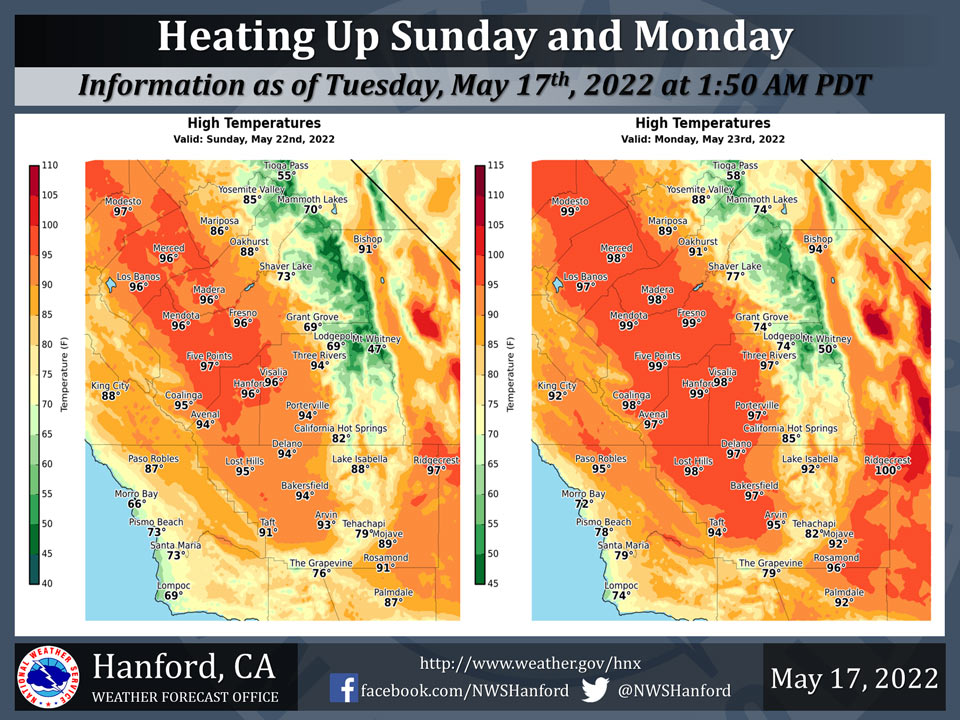
Mariposa projected high temperature for Sunday: 86 degrees, Monday: 89 degrees
Oakhurst projected high temperature for Sunday: 88 degrees, Monday: 91 degrees
Yosemite Valley projected high temperature for Sunday: 85 degrees, Monday: 88 degrees
May 17, 2022 - The National Weather Service Hanford Office reports high temperatures throughout Central California Sunday afternoon will be around ten degrees above normal for this time of year.
Maximum temperatures across Central California Monday afternoon will be twelve to fourteen degrees above their typical values for the latter half of May.
  Area Forecast Discussion
  National Weather Service Hanford CA
  1217 AM PDT Tue May 17 2022


  .SYNOPSIS...
  Dry weather continues across the region today as high pressure
  starts to rebuild. A warming trend will occur Wednesday and
  Thursday, taking the area 10 degrees above normal. Cooler Friday
  with temps rebounding sharply over the weekend. Afternoon highs
  in the upper 90s will be possible early next week. No rain is
  forecast for at least the next 7 days.

  &&

  .DISCUSSION...
  Onshore gradients are finally weakening over the area early this
  morning, which will allow for winds to relax over the Kern County
  Mountains today. Afternoon highs may trend a degree or two above
  yesterday as high pressure starts to build over the Eastern
  Pacific. The cooler airmass we had Monday/Tuesday will quickly
  modify on Wednesday and Thursday as high pressure over the Eastern
  Pacific builds. Afternoon highs in the mid 90s are expected across
  the San Joaquin Valley both days.

  Cooler and windier conditions will occur late Thursday into Friday
  as a trough of low pressure enters the Great Basin. Ensemble
  guidance is showing this trough exiting the area rather quickly,
  though. So that means that the cooling trend we get on Friday will
  be short lived. High pressure looks to reestablish itself over the
  Eastern Pacific this weekend, which will allow for afternoon highs
  to increase several degrees on Saturday compared to Friday`s
  highs. Low 90s for high temperatures is being advertised by the
  latest NBM run on Saturday, with mid 90s forecast for Sunday.

  Ensembles generally show the ridge strengthening Monday, which
  would allow for highs to run up a few more degrees. This means
  upper 90s for afternoon highs look conceivable for Monday, and
  then possibly again on Tuesday. NBM probabilistic guidance has
  backed off a bit from yesterday with regards 100 degree heat on
  Monday. It is now showing 25-35% chance of 100 degrees for Monday.
  Regardless of if hits 100 or not, it will still be quite hot for
  this time of the year. Again, we are urging people not to enter
  area rivers to seek relief from this heat through, as currents can
  be swift and waters can be much colder than expected, leading to
  dangerous conditions. Dry weather is expected to continue for at
  least the next 7 days.


  &&


  .AVIATION...
  VFR conditions will prevail throughout Central California for at
  least the next 24 hrs.

  &&

  .AIR QUALITY ISSUES...
  None.
Source: NWS
