


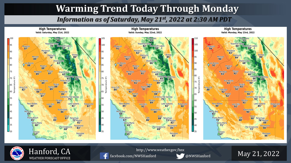
Mariposa Projected High Temperatures for Saturday through Monday: 79-83 Degrees
Oakhurst Projected High Temperatures for Saturday through Monday: 79-84 Degrees
Yosemite Valley Projected High Temperatures for Saturday through Monday: 79-84 Degrees
May 21, 2022 - The National Weather Service Hanford Office reports high temperatures throughout Central California this afternoon will be six to eight degrees warmer than yesterday afternoon.
By Monday afternoon, maximum temperatures across Central California will be six to eight degrees above normal for this time of year.
  Area Forecast Discussion
  National Weather Service Hanford CA
  1223 AM PDT Sat May 21 2022

  .SYNOPSIS...
  A warming trend is expected today through Monday. By Monday
  afternoon, high temperatures will be seven to nine degrees above
  normal for this time of year. Summer-like heat is expected Tuesday
  through Thursday. Triple digit heat is possible in the San Joaquin
  Valley Wednesday afternoon. Dry weather will persist for the
  foreseeable future.

  &&

  .DISCUSSION...
  Cyclonic flow aloft is expected today through Monday. Be that as
  it may, a warming trend is anticipated. Maximum temperatures this
  afternoon will be around five degrees warmer than yesterday
  afternoon. High temperatures Sunday afternoon will be two to four
  degrees warmer than this afternoon. By Monday afternoon, maximum
  temperatures will be seven to nine degrees above their typical
  values for the latter half of May.

  A ridge of high pressure will move eastward over the Eastern
  Pacific Ocean Monday night and Tuesday. This ridge of high
  pressure will progress eastward over California Tuesday night,
  before entering the Great Basin Wednesday. A trough of low
  pressure may approach the coast of the Golden State Thursday.
  Summer-like heat is anticipated Tuesday through Thursday. Maximum
  temperatures in the San Joaquin Valley Tuesday afternoon and
  Thursday afternoon will be in the mid to upper 90s, which is about
  ten degrees above normal for this time of year. The hottest day is
  expected Wednesday. Triple digit heat is possible in the San
  Joaquin Valley Wednesday afternoon. Here are probabilities of
  triple digit heat for select locations in the San Joaquin Valley
  on Wednesday, May 25th:

  Fresno - 54%
  Reedley - 48%
  Merced - 44%
  Hanford - 44%
  Bakersfield - 42%
  Madera - 37%
  Visalia - 34%
  Lemoore - 34%
  Delano - 31%
  Porterville - 27%

  The aforementioned trough of low pressure may pass over Northern
  California Friday, resulting in a reprieve from the heat. Maximum
  temperatures Friday afternoon will be six to eight degrees lower
  than Thursday afternoon. In addition, strong, gusty west to
  northwest winds are possible in the Kern County desert Friday
  afternoon and Friday night. A Wind Advisory may be required. Dry
  weather will persist through at least the next seven days.

  &&

  .AVIATION...
  VFR conditions will prevail throughout Central California today
  and tonight.

  &&

  .AIR QUALITY ISSUES...
  None.
Source: NWS
