


Includes Yosemite National Park, Eastern Madera County and Eastern Mariposa County
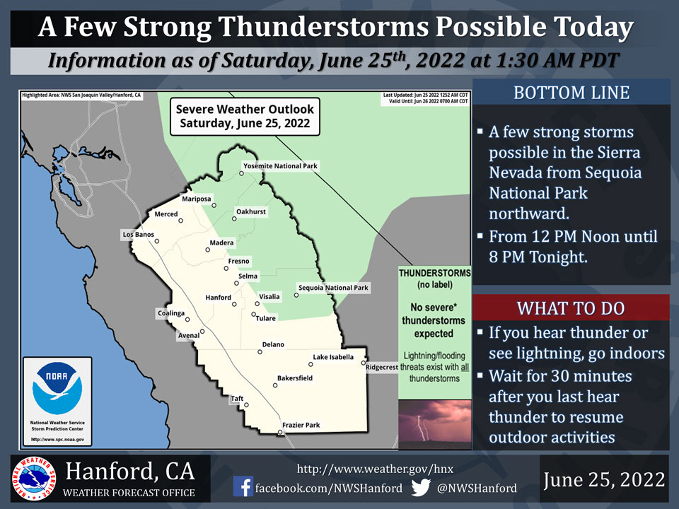
June 25, 2022 - The National Weather Service Hanford Office reports a few strong thunderstorms are possible in the Sierra Nevada from Sequoia National Park northward this afternoon.
Dangerous cloud to ground lightning strikes, wind gusts near 45 mph, and small hail are hazards associated with strong thunderstorms.
Area Forecast Discussion
National Weather Service Hanford CA
218 AM PDT Sat Jun 25 2022
.SYNOPSIS...
One more round of high elevation thunderstorms in the Sierra
Nevada are possible this afternoon. Unseasonably warm weather will
occur through the forecast area through Monday. A cooling trend
back to near normal temperatures is likely later next week.
&&
.DISCUSSION...
Afternoon highs yesterday were quite hot across the San Joaquin
Valley, with a few readings around 105* F measured. The warming
trend continues into today, so more widespread 105* F highs are
likely. The ridge pattern gets more defined on Sunday and remains
strong Monday. Sunday and Monday will likely be the hottest days
of the forecast period, with some areas across the valley forecast
to reach 105-107 degrees. Warm overnight lows will provide little
relief over the weekend. Due to the combination of warm overnight
lows and hot daytime high temperatures, a Heat Advisory was
issued for the SJ Valley, Coastal Range, lower Sierra Nevada
Foothills, and the lower Kern River Valley starting Noon today
through 9 PM Monday. Outside of the heat forecast, one last round
of thunderstorms in the Sierra Nevada, mainly north of Tulare
County, are possible this afternoon.
Ensemble guidance continues to show a trough entering the Pacific
Northwest on Tuesday, which begins to erode away at the ridge
pattern over Central California. This will start a cooling trend
that may take afternoon highs back to seasonal norms by Friday and
Saturday across the forecast area as the trough pattern locks in
place in the Pacific NW. Highs in the low to mid 90s are expected
by that time frame across the valley. There could be some periods
of breezy conditions in the wind prone areas if an onshore flow
pattern can set up by late next week. Dry weather is expected to
prevail for all of next week.
&&
.AVIATION...
IFR or lower conditions are likely in and near scattered showers
and thunderstorms in the Sierra Nevada after 18Z Saturday through
03z Sunday. Otherwise, VFR conditions will prevail across the
Central California Interior for at least the next 24 hours.
&&
.AIR QUALITY ISSUES...
On Saturday June 25 2022... Unhealthy for Sensitive Groups in
Fresno... Kern... Kings... Madera... Merced and Tulare Counties...
and Sequoia National Park and Forest.
Source: NWS
