


Click here for: Mariposa County Oak Fire Updates for Tuesday, July 26, 2022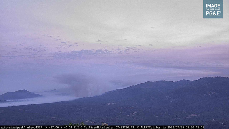
Oak Fire in Mariposa County from the PG&E Miami Peak Live Camera on Monday Morning, July 25, 2022 at 5:50 A.M
Note: CAL FIRE Community Meeting Video for the Oak Fire in Mariposa County on Sunday, July 24, 2022
Click here for: Mariposa County Oak Fire Updates for Tuesday, July 26, 2022
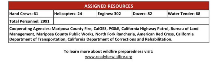
Evening Update CALFIRE: 17,241 Acres, 16% Containment, Personnel 2,991, with 21 Residences & 34 Outbuildings Destroyed.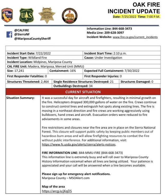
Update 4:00 P.M.: Mariposa County Resource Information Guides for Residents Affected by the Oak Fire
Update 3:45 P.M.: CAL FIRE Statewide Fire Update Video for Monday, July 25, 2022
Update 3:28 P.M.: Mariposa County Announces Free Residential Spoiled Food Waste Collection for Area Residents Affected by the Oak Fire
Update 1:30 P.M. Per Mariposa County Sheriff’s Department: Oak Fire Evacuation Orders Reduced to Fire Advisement in Some Areas of Mariposa County
Update Video: Mariposa County Oak Fire Operational Video Update for Monday, July 25, 2022
Update 12:08 P.M.: TRAFFIC ADVISORY for State Route 140 Closed from Route 49 to Ponderosa Way Due to the Oak Fire in Mariposa County
The California Department of Transportation (Caltrans), in conjunction with Cal Fire and the California Highway Patrol, has closed State Route 140 from the north junction of Route 49 to Ponderosa Way in Mariposa County due to the Oak Fire.
There is no estimated time of reopening. Motorists are advised to avoid the area and find an alternate route.
The Oak Fire started at approximately 2:10 p.m. on Friday, July 22, 2022, at Route 140 and Carstens Road near Midpines. The fire has burned 16,791 acres and is 10 percent contained, according to Cal Fire.
For information about the Oak Fire, including road closures and evacuation orders, visit Cal Fire’s web site at fire.ca.gov/incidents/2022/7/22/oak-fire. For road information regarding Yosemite National Park, call 209-372-0200 (then press 1) or visit nps.gov/yose/planyourvisit/conditions.htm.
For the latest road information, visit quickmap.dot.ca.gov.
Update for 8:56 A.M. CALFIRE: 16,791 Acres with 10% Containment, Personnel 2,548.
|
Last Updated |
07/25/22 8:56 AM |
|
Date Started |
07/22/22 2:10 PM |
|
Location Information |
Hwy 140 and Carstens Rd, near Midpines |
|
Lat/Long |
[37.5509366, -119.9234728] |
|
Administrative Unit |
Unified Command: CAL FIRE Madera-Mariposa-Merced Unit and Sierra National Forest |
|
Command Team |
CAL FIRE Incident Management Team 5 |
|
Cause |
Under Investigation |
|
Reports |
Status Updates
Situation Summary
The fire remained active in some areas, throughout the evening, due to dry dead and downed fuels. Previous reporting on damaged structures was a preliminary estimate. Work from damage inspection teams have confirmed seven single residence structures have been destroyed. Work continues with damage inspection teams throughout the fire area. The fire fight continues in hot, dry conditions and steep, rugged terrain.
Fire restrictions are in place on the Sierra National Forest. For additional information, visit: https://www.fs.usda.gov/alerts/sierra/alerts-notices.
FIRE INFORMATION LINE: 844-MMU-FIRE (844-668-3473) This information line is extremely busy and will roll over to Mariposa County History Information voicemail when all lines are being utilized. Please be patient, your call will be answered when a line becomes available.
Please sign up for emergency alert notifications. Mariposa County – MSOAlert.com
Map of the area: https://Arcg.is/STL1u0
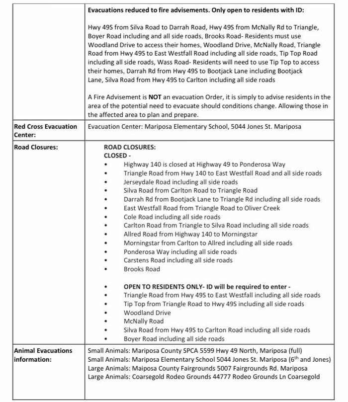
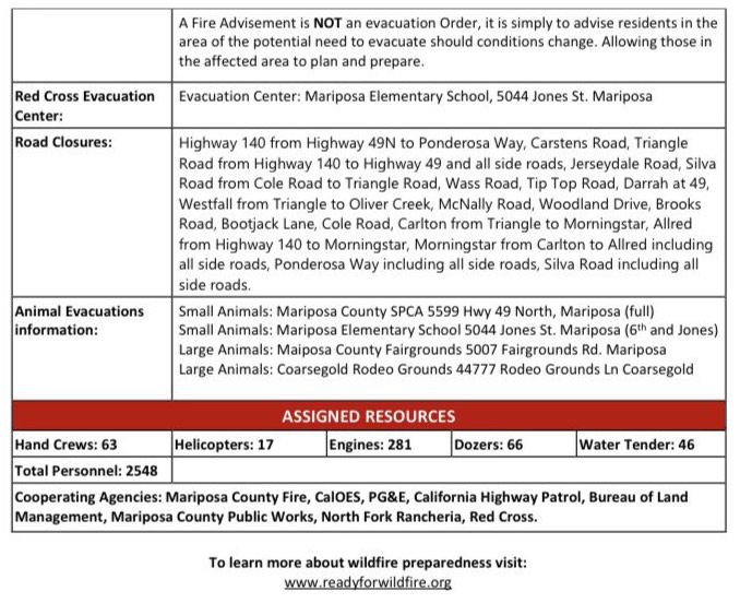
Road Closures:
- Highway 140 from Highway 49N to Ponderosa Way
- Carstens Road, Triangle Road from Highway 140 to Highway 49 and all side roads
- Jerseydale Road
- Silva Road from Cole Road to Triangle Road
- Wass Road
- Tip Top Road
- Darrah at 49
- Westfall from Triangle to Oliver Creek
- McNally Road
- Woodland Drive
- Brooks Road
- Bootjack Lane
- Cole Road
- Carlton from Triangle to Morningstar
- Allred from Highway 140 to Morningstar
- Morningstar from Carlton to Allred including all side roads
- Ponderosa Way including all side roads
- Silva Road including all side roads.
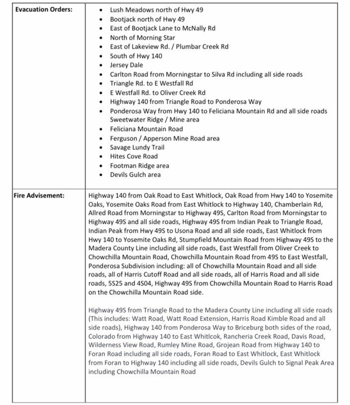
Evacuation Orders:
- Carstens Road
- Buckingham Mountain RoadPlumbar Creek Road
- Triangle Road from Hwy 140 to Darrah
- Jerseydale and all side roads
- Lushmeadows Subdivision
- Triangle Road from Darrah Road to Westfall Road and all side roads
- Boyer Road from Highway 49S and all side roads
- Darrah Road from Highway 49S to Triangle Road including all side roads
- Triangle Road from 49S to Westfall Road and all side roads including Triangle Park
- Tip Top Road
- Wass Road
- Westfall from Triangle to Oliver Creek
- Silva Road from Cole to Triangle including all side roads
- Ginger Trish Road
- Cole Road to Darrah Road including all side roads
- McNally Road
- Highway 49S from Darrah Road to Triangle Road (east side only)
- Woodland Drive
- Brooks Road
- Carlton from Triangle to Morningstar Lane
- Morningstar from Carlton to Allred Rd including all side roads
- Indian Rock Lane
- Allred from 140 to Morningstar
- Westside of Highway 140 from Triangle Road to Allred Road.
- Carlton Road from Morningstar to Silva Road including all side roads
- Silva Road from Carlton to Hwy 49S including all side road
- Shaffer Road from Silva Road to Allred Road
- Hwy 49S from Silva to Darrah Road (on the Bootjack Market Side)
- Hwy 140 from Triangle Road to Ponderosa Way (on the Midpines Market side of Hwy 140), Ponderosa Way from Hwy 140 to Feliciana Mountain Rd and all side roads
- Sweetwater Ridge / Mine area
- Feliciana Mountain Road
- Ferguson / Apperson Mine Road area
- Savage Lundy Trail
- Hites Cove Road
- Footman Ridge area
- Devils Gulch area.
Evacuation Warnings:
- Highway 140 from Oak Road to East Whitlock
- Oak Road from Hwy 140 to Yosemite Oaks
- Yosemite Oaks Road from East Whitlock to Highway 140, Chamberlain Rd
- Allred Road from Morningstar to Highway 49S
- Carlton Road from Morningstar to Highway 49S and all side roads
- Highway 49S from Indian Peak to Triangle Road
- Indian Peak from Hwy 49S to Usona Road and all side roads
- East Whitlock from Hwy 140 to Yosemite Oaks Rd
- Stumpfield Mountain Road from Highway 49S to the Madera County Line including all side roads
- East Westfall from Oliver Creek to Chowchilla Mountain Road
- Chowchilla Mountain Road from 49S to East Westfall
- Ponderosa Subdivision including: all of Chowchilla Mountain Road and all side roads, all of Harris Cutoff Road and all side roads
- all of Harris Road and all side roads
- 5S25 and 4S04
- Highway 49S from Chowchilla Mountain Road to Harris Road on the Chowchilla Mountain Road side.
- Highway 49S from Triangle Road to the Madera County Line including all side roads (This includes: Watt Road, Watt Road Extension, Harris Road Kimble Road and all side roads)
- Highway 140 from Ponderosa Way to Briceburg both sides of the road
- Colorado from Highway 140 to East Whitlcok
- Rancheria Creek Road
- Davis Road
- Wilderness View Road
- Rumley Mine Road
- Grojean Road from Highway 140 to Foran Road including all side roads
- Foran Road to East Whitlock
- East Whitlock from Foran to Highway 140 including all side roads
- Devils Gulch to Signal Peak Area including Chowchilla Mountain Road
A Fire Advisement is NOT an evacuation Order, it is simply to advise residents in the area of the potential need to evacuate should conditions change. Allowing those in the affected area to plan and prepare.
Evacuation Centers:
Mariposa Elementary School, 5044 Jones St. Mariposa.
Animal Evacuation Centers:
- Small Animals: Mariposa County SPCA 5599 Hwy 49 North, Mariposa (full)
- Small Animals: Mariposa Elementary School 5044 Jones St. Mariposa (6th and Jones)
- Large Animals: Mariposa County Fairgrounds 5007 Fairgrounds Rd. Mariposa
- Large Animals: Coarsegold Rodeo Grounds 44777 Rodeo Grounds Ln Coarsegold
Damages and Losses
Confirmed Damage to Property, Injuries, and Fatalities
0 Structures Damaged
Residential, Commercial and Other
7 Structures Destroyed
Residential, Commercial and Other
Resources Assigned
CAL FIRE owns and operates over 3,000 fire and emergency response and resource protection vehicles. In support of its ground forces, the CAL FIRE emergency response air program includes 23 Grumman S-2T 1,200 gallon airtankers, 12 UH-1H Super Huey helicopters, and 16 OV-10A airtactical. From 13 air attack and 10 helitack bases located statewide, aircraft can reach most fires within 20 minutes.
17 Helicopters
281 Engines
66 Dozers
46 Water Tenders
2,548 Personnel
63 Crews
Update 6:00 A.M. Caltrans Road Conditions
Update 6:00 A.M. Air Quality Measurements
Update 6:00 A.M. Oak Fire in Mariposa County Public Information and Briefing Maps for Monday, July 25, 2022
Update for 8:05 A.M. CALFIRE: 16,791 Acres with 10% Containment.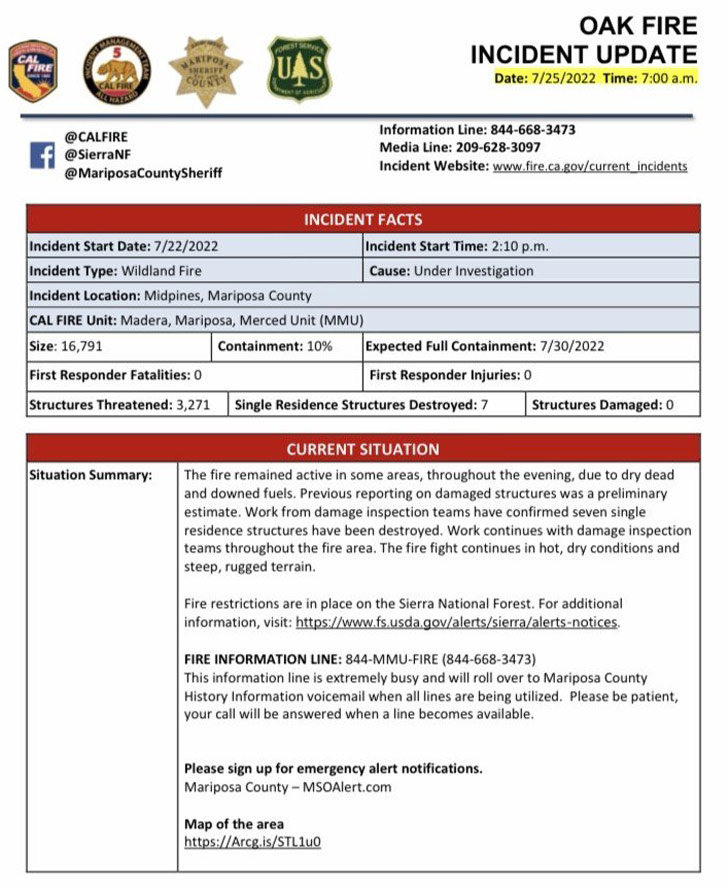

Click here for: Mariposa County Oak Fire Updates for Sunday, July 24, 2022
