


California and National Drought Summary for July 26, 2022
Summary
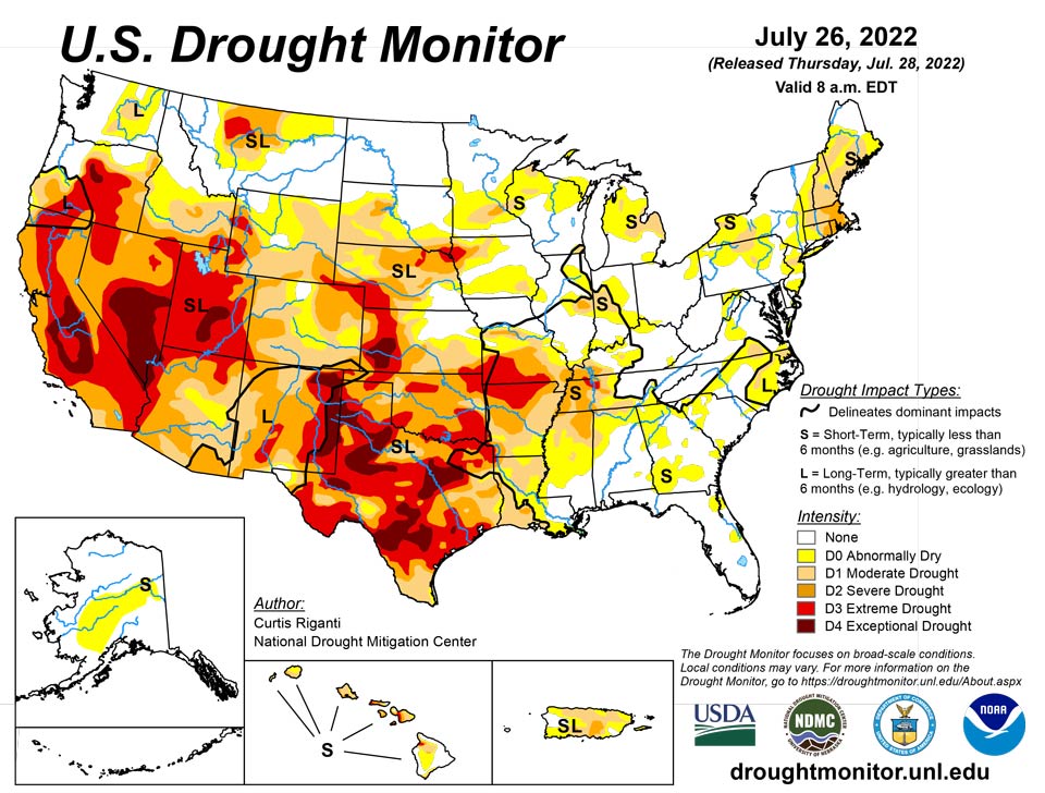
July 28, 2022 - Drought persisted across much of the West this week, while flash drought over parts of the Great Plains, Ozarks, and Mississippi Valley continued to intensify and cause agricultural problems. Short-term drought also expanded over parts of the Northeast this week, where deficits in short-term precipitation and streamflows mounted in some areas. Conditions locally improved in parts of the Southwest due to an influx of rainfall from the North American Monsoon. Farther east into the lower Great Plains and Midwest, localized heavy rainfall led to improvements, including severe flooding in the St. Louis Metro area, which previously had been experiencing abnormally dry conditions. In Alaska, moderate drought was mostly removed after recent rainfall improved conditions there.
Northeast
Generally hot weather occurred in the Northeast this week, as most of the region saw temperatures 4-8 degrees Fahrenheit above normal. Drier weather also occurred in the eastern coastal areas; this led to growing precipitation deficits, reductions in streamflow, poor soil moisture, and water shortages in some areas. Severe drought expanded in coverage in eastern Massachusetts, Rhode Island, and eastern Connecticut. Widespread calls for water conservation occurred from New England to the Hudson Valley and New Jersey, and hay fields struggled in Rhode Island.
Southeast
Spotty heavy rain fell in the Southeast region this week, while some areas remained dry. Temperatures were mostly within a couple degrees of normal, except for northern Alabama, North Carolina, and Virginia, where temperatures were 2-6 degrees above normal. Moderate and severe drought expanded slightly in northern Alabama in areas missed by heavy rains. Lake Wilson in eastern North Carolina has been drying as a result of ongoing moderate drought. In areas that received more rainfall, such as near Savannah, Georgia, conditions improved enough for drought to end. Due to recent rains, short-term moderate drought in northern Georgia also ended.
South
Weather across the South this week was mostly hot and dry, with some notable exceptions. Heavier rain occurred in southern Louisiana and southern Mississippi, as well as eastern Tennessee. Very localized heavy rain fell from east-central Oklahoma into southwest Arkansas. Temperatures across the region were generally 2-8 degrees warmer than normal, with the warmest readings occurring in Oklahoma, Texas, northern Arkansas, and the western half of Tennessee. Flash drought conditions intensified further in central and northern Arkansas, central and eastern Oklahoma, and in spots in western Tennessee, northern Mississippi, northern Louisiana, and eastern and southern Texas. Crop failure and related problems are widespread in the part of the region experiencing flash drought, especially in northeast Texas, eastern and central Oklahoma, and northern Arkansas.
Midwest
The Midwest saw a mix of degradations and improvements in the Drought Monitor this week, after weather was highly variable across the region. Hot and dry weather covered south-central and southwest Missouri, where flash drought continued to intensify and agricultural problems continued as a result. Just to the north of this region, heavier rains fell in two areas, one from southeast of Kansas City to southeast Missouri, and a second in central, eastern, and northeast Missouri. The latter caused flash flooding in the St. Louis area and a record one-day rainfall at St. Louis Lambert Airport. Both areas of heavy rain set up tight north-to-south gradients in drought and abnormal dryness conditions in Missouri. Improvements to the drought situation occurred in parts of northeast Illinois, though heavier rains missed the severe drought area centered near Champaign. Drought expansion paused this week in the Michigan Lower Peninsula where widespread rain fell. Localized improvements were made in parts of Indiana, Ohio, and Kentucky where short-term conditions improved due to heavy rainfall. A mix of improvements and degradations occurred in Minnesota and Wisconsin around areas where heavier rain fell. Soil moisture deficits continued to mount in far northern Wisconsin, where moderate drought developed.
High Plains
With the exception of Colorado (which was mostly warmer than normal) and southern Kansas (which was 4-8 degrees warmer than normal), temperatures in the High Plains region this week were generally within 2-4 degrees of normal. Rainfall from the North American Monsoon occurred in parts of southern, central, and eastern Colorado, locally easing drought conditions in the eastern part of the state. Heavy rains in south-central and southwest South Dakota, and in southern Nebraska, northern Kansas, and east-central Kansas, led to locally improved drought and dryness conditions. Meanwhile, south of the heavier rains, flash drought continued to take hold in southern Kansas, where a combination of dry and hot weather worsened conditions. Extreme drought expanded in parts of southwest Nebraska, where short- and long-term precipitation deficits worsened conditions amid poor crop health. Drought also expanded in northeast Nebraska and southeast South Dakota, where soil moisture deficits continued to mount amid warm temperatures and dry weather. Extreme drought also developed in western Wyoming, where above-normal evaporative demand combined with short-term precipitation deficits to worsen conditions locally.
West
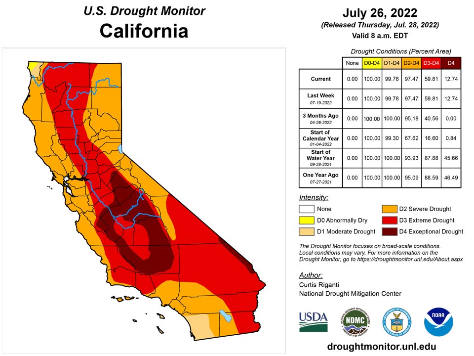
Rainfall from the North American Monsoon over the last few weeks led to some improvements in the drought situation across Arizona and New Mexico, where precipitation deficits lessened. Rain also fell in parts of Nevada, Utah, and eastern California this week. Temperatures were mostly 2-6 degrees above normal in the West region, though scattered areas were within a couple degrees of normal. Precipitation deficit amounts lessened enough for some improvement to ongoing short- and long-term drought in central Montana. Elsewhere, widespread drought continued this week across a large portion of the region.
Caribbean
Drought conditions were unchanged this week in Puerto Rico. Above-normal rainfall occurred near the southeast coast, the north-central coast, and parts of west-central Puerto Rico. Below-normal rainfall occurred in parts of northwest, southwest, and south-central Puerto Rico this week.
Beneficial rains fell across the US Virgin Islands, with rainfall totals ranging between half an inch to close to 2 inches for the week. However, drought classifications of severe to extreme drought persisted in the region since groundwater levels across the three islands didn't improve much. In St. John, the Windswept Beach station had 1.33 inches of rain, which resulted in a month-to-date total of 2.81 inches or 101.9% of normal. Other CoCoRaHS stations had 1.32 to 1.57 inches of rain for the week. According to the SPI values, drought free conditions were present at the 1 month period; however, moderate to severe drought was evident at the 3, 6, 9 and 12 months.
Similarly, the Cyril E King airport at St. Thomas had 1.05 inches for the week, while the CoCoRaHS stations across the island had 0.59 to 1.73 inches of rain. The month-to-date total at the airport was 1.86 inches, which is 81.9% of normal rainfall. SPI values were indicative of moderate to extreme drought at the 3, 6, 9, and 12 months, while drought free conditions were indicative at the 1 month period.
The Henry E. Rohlsen airport, St. Croix had 0.70 inch of rain this week and close to 3 inches for the month-to-date, which is 138.9% of normal. Rainfall totals varied across the CoCoRaHS stations on the island (0.59 inch to 1.73 inches). Similarly, to the other two islands, SPI values at the 1 month indicated drought free conditions. However, SPI values at the 3, 6, 9, and 12 months depicted moderate to extreme drought.
Pacific
Heavy rains in parts of Alaska this week led to widespread improvements in drought there, leaving a small area of short-term moderate drought in the east-central part of the state.
Drought conditions in Hawaii this week were unchanged; rainfall in the state was below normal in many locations.
Drought free conditions persisted across most locations in the US Affiliated Pacific Islands during this drought week. Most locations in Palau, Marianas, the Marshall Islands, and across parts of the Federated States of Micronesia had a wet week with rainfall totals over 2 inches. American Samoa, which only requires 1 inch of rain each week to meet most water needs, also had rainfall totals above its threshold. In the Marianas, Guam had the most rain across the stations analyzed in the region with 5.58 inches of rain, surpassing its monthly threshold of 4 inches in just one week. Saipan (Marianas) and Majuro (Marshall Islands) had over 4 inches of rain, while Pohnpei, Kosrae (both in the Federated States of Micronesia), Ailinglaplap, Kwajalein, and Jaluit (in the Marshall Islands) had over 3 inches of rain.
Beneficial rains have fallen across Majuro the last few weeks, resulting in a month-to-date total of 9.71 inches, which is above the monthly threshold of 8 inches to meet most water needs. Information from locals have stated that there are currently no water issues and the reservoir levels are at 83% of the current maximum capacity of 26 million gallons. For this reason, Majuro's drought classification was changed to drought free conditions.
Meanwhile, Lukunor, Kapingamarangi, Nukuoro (Federated States of Micronesia) and Wotje (Marshalls) were the only locations to have received less than 1 inch of rain for the week. Kapingamarangi continued in long-term moderate drought since residents continue to conserve water and crops and vegetation were still yellow. While the other locations were left as drought free since their month-to-date rainfall totals surpassed the monthly threshold of 8 inches to meet most water needs.
Looking Ahead
Through the morning of Tuesday, August 2, the National Weather Service Weather Prediction Center is forecasting heavy rainfall to occur from northern New Mexico and southern Colorado eastward across parts of the southern Great Plains, Mid-South, and southern Appalachians, including some areas currently experiencing flash drought. Pockets of heavy rain also may occur in western New Mexico and portions of Arizona. Elsewhere, rainfall is forecast to remain generally spotty, with many areas staying dry or mostly dry. During this period, hot weather is forecast in the Northwest, while hot temperatures are forecast over the northern Great Plains and cooler-than-normal weather is likely in the central Great Plains during the weekend (July 30-31). Temperatures are forecast to return to near-normal levels in these areas, and then may begin to warm as Tuesday, August 2 approaches.
For the period of August 2-6, the National Weather Service Climate Prediction Center forecast strongly favors warmer than normal temperatures over the eastern two-thirds of the contiguous United States, especially in the Middle Missouri River Valley. Below normal precipitation is favored in the central Great Plains, and to a lesser extent is also favored in parts of the Midwest and eastern Great Lakes. Above normal precipitation and below normal temperatures are favored in much of the western United States. Above normal precipitation is favored in east-central Alaska, while southwest Alaska is likelier to see below normal precipitation. Most of Alaska, excepting the far northern areas, is likelier to see below normal temperatures.
Author(s):
Curtis Riganti, National Drought Mitigation Center
Ahira Sanchez-Lugo, NOAA/NCEI
Dryness Categories
D0 Abnormally Dry—used for areas showing dryness but not yet in drought, or for areas recovering from drought.
Drought Intensity Categories
D1 Moderate Drought
D2 Severe Drought
D3 Extreme Drought
D4 Exceptional Drought
Drought or Dryness Types
S Short-term, typically less than 6 months (agriculture, grasslands)
L Long-term, typically more than 6 months (hydrology, ecology)
SL Area contains both short- and long-term impacts
Source: National Drought Mitigation Center
