


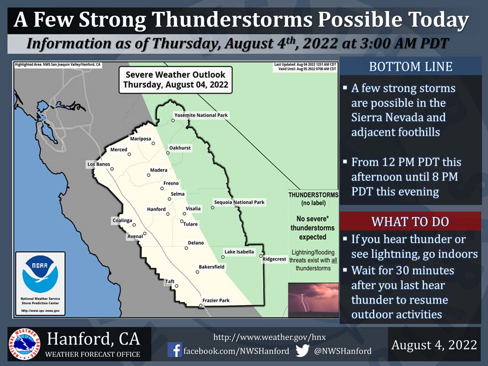
Includes Eastern Madera and Mariposa Counties and Yosemite National Park
August 4, 2022 - The National Weather Service Hanford Office reports a few strong thunderstorms are possible in the Sierra Nevada and adjacent foothills from 12:00 P.M. this afternoon until 8:00 P.M. this evening.
Dangerous cloud to ground lightning strikes and wind gusts near 45 mph are a couple of hazards associated with strong thunderstorms.
In addition, any thunderstorm can produce intense rainfall rates, leading to localized flooding.
Area Forecast Discussion
National Weather Service Hanford CA
330 AM PDT Thu Aug 4 2022
.SYNOPSIS...A surge of moisture from the southeast will bring
showers and thunderstorms to much the Sierra Nevada, adjacent
foothills and the mountains and deserts of eastern Kern County
today and again on Friday. Daytime temperatures will finally cool
to near seasonal normals on Friday. A drier airmass will prevail
over the area this weekend, keeping precipitation chances
confined to the higher Sierra. Another tropcial moisture surge
will make it's way into the area early next week bringing
increased precipitation chances to the area by Monday.
&&
.DISCUSSION...Upper high pressure centered over the four corners
area is providing central CA with a moist southeast flow aloft. IR
imagery is showing a mesoscale convective system (MCS) over
southern AZ which is tracking northwest toward southern NV and far
eastern CA. As a result, these areas will be impacted by
thunderstorms later today with heavy rainfall and a potential for
flash flooding. While QPF progs are showing that the heavier
precipitation will remain to the east of our area, locally heavy
rainfall is possible later today over the higher elevations of the
Sierra Nevada and over the desert areas in eastern Kern County.
The other concern for today is the continuation of above normal
temperatures with highs at most locations expected to range
between 102 and 105 Deg F. By Friday, increased cloud cover will
help keep daytime temepratures down and NBM probabilistic guidance
is indicating most locations in the San Joaquin Valley will have
between a 50 and 70 percent chance of maximum temperatures below
100 Deg F. The presence of mid/upper level tropical moisture over
the area will mean a continuation of precipitation chances for
much of our area.
The four corners high is expected to shift eastward into the
central CONUS over the weekend which will result in a drier
southwest flow over central CA which will keep precipitation
chances confined to the higher Sierra with temepratures expected
to be slightly above seasonal normals.
The medium range ensembles are favoring the upper ridge
retrograding westward early next week as an upper trough hangs
around 130W which will result in the flow aloft becoming south to
southeast which will open the door for another surge of mid/upper
level tropcial moisture to stream into central CA on Monday and
Tuesday. This in turn will bring increasing chances of showers and
thunderstorms back to our area by early next week, most noticably
over the Sierra Nevada range.
&&
.AVIATION...Areas of mountain obscuring IFR in thunderstorms over
the Sierra Nevada and Tehachapi Mountains after 18Z Thu. Otherwise,
VFR conditions will prevail for the next 24 hours.
&&
.AIR QUALITY ISSUES...On Thursday August 4 2022... Unhealthy for
Sensitive Groups in Fresno... Kern and Tulare Counties... and
Sequoia National Park and Forest.
Source: NWS
