


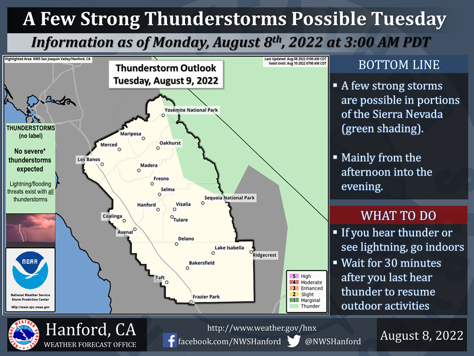
Includes Eastern Madera and Mariposa Counties and Yosemite National Park
August 9, 2022 - The National Weather Service Hanford Office reports a few strong thunderstorms are possible in the Sierra Nevada, including the edge of Yosemite NP to the edge of Sequoia NP, on Tuesday afternoon and evening.
Dangerous cloud to ground lightning strikes and wind gusts near 45 mph are a couple of hazards associated with strong thunderstorms.
In addition, any thunderstorm can produce intense rainfall rates that may lead to localized flooding.
Area Forecast Discussion...UPDATED
National Weather Service Hanford CA
327 AM PDT Tue Aug 9 2022
.SYNOPSIS...
About average temperatures for the next few days leading into a
warm up to triple digits by the weekend. Thunderstorms in the
Sierra Nevada will start back up this afternoon and early evening.
&&
.DISCUSSION...
Upper low off the Northern California continues to influence the
weather across the Central California Interior. Along with the
surge of monsoonal moisture from the Baja California region, the
district will see another day of isolated mountain/desert
convection in the afternoon and early evening. Satellite moisture
imagery is showing the moisture surge well into much of Central
California as precip-water (PW) analysis and upper air observation
showing the 1.5 inch PW well into the desert southwest. Yuma, AZ
sounding Monday afternoon showed a value of 2.26 inches, which is
in the range of its Daily Max value. Closer to home, Vandenberg
had a PW value of about 1.2 inches. Therefore, higher moisture
over the region will raise the certainty of convection this
afternoon as flooding from excessive rain may pose a problem of
some of our afternoon thunderstorms. The upper low will continue
to shift toward the Pacific Northwest and change to direction of
the flow aloft. Therefore, lingering showers on Wednesday will
give way to drier conditions later in the week as a southwesterly
flow aloft dominates the region.
Hi-Res short range ensembles favoring a shift the upper level
pattern as the ridge axis is pushed further inland and closer to
the Rockies. This shift will lessen the threat of thunderstorm
over the district. While thunderstorms may linger into Wednesday,
ensemble analysis shows less coverage over Central California. By
Thursday, Cluster analysis shows fairly good agreement in taking
the upper low closer to Canada as confidence grows in the
northeastward progression of the upper low. However, Cluster
analysis does not show a strong signal toward moving the upper low
over the ridge pattern. Therefore, once the upper low moves
further north, will will stall and place the region on a more
southwesterly flow pattern. Once this occurs, the region drys out
as thunderstorms and their threats shift more over the Four
Corners/Great Basin region.
Looking at Cluster analysis further out and closer to the weekend,
ensemble begin showing a signal toward retrograding the ridge
pattern. While uncertainty grows on the possible track of the
upper low toward the end of the weekend, the general consensus is
the move it across Canada as heights over the West Coast begin
rising early next week. NBM surface temperature forecast is
responding to the rising West Coast heights by increasing the
triple digit coverage across the San Joaquin Valley around the end
of the week (and into the weekend) as the heat returns.
Uncertainty grows in further toward the latter part of the
forecast in the early parts of next week. Ensembles hinting toward
placing the center of the high near the Four Corners area and
allow for another surge of monsoon moisture. Will see if this
pattern holds and moisture is able to return around the middle of
next week.
&&
.AVIATION...
Scattered thunderstorms over the Sierra Nevada will be possible
after 18Z today and continue through 04Z Wednesday. Otherwise,
VFR conditions will prevail for the next 24 hours.
&&
.AIR QUALITY ISSUES...
On Tuesday August 9 2022...Unhealthy for Sensitive Groups in Kern
County and Sequoia National Park and Forest.
Source: NWS
