


California and National Drought Summary for September 6, 2022
Summary
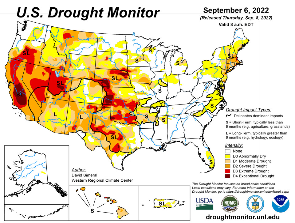
September 8, 2022 - This U.S. Drought Monitor (USDM) week saw continued improvements on the map across areas of the South, including Texas, in response to another round of localized heavy rainfall during the past week. Overall, the recent rainfall in Texas throughout the past month has started to make a significant dent in the state’s drought conditions in some areas. In contrast, drought conditions intensified in areas of the central and northern Plains with additional degradations on this week’s map. In these areas, recent drought impact reports submitted to the National Drought Mitigation Center indicated drought-related impacts within the agricultural sector including reduced crop yields as well as deteriorating pasture and rangeland conditions. Out West, the big story of the past week has been the heat wave that has impacted the region with record-setting temperatures and critical fire-weather conditions. The hot temperatures and strong winds exacerbated conditions on the Mill Fire, which broke out in Northern California on Friday, forcing the evacuation of the town of Weed, California as well as neighboring communities. In Death Valley, California, high temperatures exceeded 125 deg F multiple times during the past week including on September 1st when the high temperature reached 127 deg F―potentially breaking the record for the hottest temperature ever recorded during September, according to preliminary reports. Elsewhere, shower activity in the Northeast led to isolated improvements in drought-affected areas of Massachusetts and Connecticut, while further to the south conditions deteriorated on the map in Delaware. In the Midwest, short-term precipitation deficits and declining soil moisture levels led to the expansion of areas of drought in northern Missouri and central Illinois.
Northeast
Some improvements were made on the map in response to widespread rainfall across much of the region during the past week. Rainfall amounts ranged from 1 to 5+ inches with the highest totals observed in northeastern Pennsylvania and southern New York. Improvements were made in areas of New York, Connecticut, Rhode Island, Massachusetts, and Maine. During the past 30-day period, rainfall departures from normal were largest along the coastal areas of New Jersey and New York, with deficits ranging from 2 to 4+ inches. Conversely, wetter-than-normal conditions prevailed in areas including central Pennsylvania, Upstate New York, isolated areas of Connecticut and Massachusetts, eastern New Hampshire, and Maine. For the week, average temperatures were 1 to 5 deg F above normal across the southern portion of the region while below-normal temperatures were observed in areas of Upstate New York, northern locales of Vermont and New Hampshire, and across much of Maine.
Southeast
During the past week, light-to-heavy rainfall accumulations (ranging from 1 to 6 inches) were observed across the region with the heaviest accumulations reported around the border intersection of Georgia, South Carolina, and North Carolina. Elsewhere, rainfall accumulations of ~3 inches were observed in isolated areas of northern Alabama, southern Georgia, Florida, western North Carolina, and southwestern Virginia. On the map, some improvements were made in northern Alabama, and South Carolina, while conditions deteriorated on the map in coastal areas of southeastern Florida where areas of Moderate Drought (D1) expanded. For the week, average temperatures were above normal across the region with the greatest departures (3 to 5 deg F above normal) observed in central Florida, northern South Carolina, central North Carolina, and eastern Virginia.
South
In the South, widespread improvements were made across Texas this week in response to another round of moderate-to-heavy rainfall that impacted isolated areas of the state, with accumulations ranging from 2 to 6+ inches. The recent rains have provided a much-needed boost to soil moisture and streamflow levels. Despite the recent rains, streamflow levels in some areas of the Hill Country have yet to recover, with gaging stations on numerous rivers and creeks reporting below-normal flows (ranging from the 2nd to the 24th percentile), according to the U.S. Geological Survey. Elsewhere in the region, this week’s rainfall led to improvements in eastern Oklahoma, northern Arkansas, northern Mississippi, and western portions of Tennessee. For the past 30-day period, much of the region experienced above-normal precipitation with the greatest positive departures (ranging from 6 to 12+ inches) observed in the Basin and Range and southern portion of the Gulf Coastal Plains of Texas, northern Louisiana, and central Mississippi. Overall, average temperatures for the week were within a few degrees of normal, with larger negative departures (2 to 4 deg F below normal) observed in western Texas.
Midwest
For the week, light to moderate (1 to 5+ inches) rainfall accumulations were concentrated mainly across the Lower Midwest with the heaviest accumulations observed in southern portions of Missouri, Indiana, and Ohio. On the map, improvements were made in areas of Abnormally Dry (D0) in northern Ohio and Indiana while areas of Moderate Drought (D1) and Severe Drought (D2) were reduced in southwestern Missouri. Conversely, short-term precipitation deficits (past 30-120 days) and negative soil moisture anomalies led to deterioration on the map in west-central Illinois and northeastern Missouri. Average temperatures for the week were above normal (ranging from 1 to 6 deg F) across much of the region, except for areas of southern Missouri, southern Illinois, and western Kentucky where temperatures were a few degrees below normal.
High Plains
On this week’s map, drought-related conditions continued to intensify across areas of southeastern Wyoming, northeastern Montana, Nebraska, southern South Dakota, and western Kansas, as anomalously hot temperatures impacted western portions of the region. According to the National Drought Mitigation Center’s Condition Monitoring Observer Reports (CMOR), numerous drought impact reports have been submitted during the past 30-day period. Impacts include reduced crop yields, poor pasture conditions, and the need for supplemental feeding of livestock. The current drought situation was exacerbated by this week’s intense heat, with average maximum temperatures ranging from 95 to 100 deg F in areas of eastern Montana, northern and eastern Wyoming, and western portions of South Dakota, Nebraska, and Kansas.
West
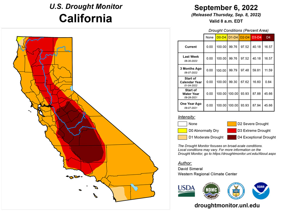
Out West, an anomalous upper-level ridge parked over the central Great Basin during the past week—leading to a dangerous heat wave and record-high temperatures across the region. The record heat exacerbated fire-weather conditions across Northern California, the Pacific Northwest, and the Northern Rockies as well as taxed California’s power grid in response to the record-high demand reported this week. Most of the region saw no precipitation this week, except for some isolated storm activity in western Washington, Arizona, eastern Colorado, and eastern New Mexico. On this week’s map, areas of drought expanded in southwestern and central Montana, and in northern Wyoming. Areas of Extreme Drought (D3) in the Four Corners region were trimmed back as part of a re-assessment of the impact of monsoonal rainfall during the past several months. Looking at reservoir storage conditions, the two largest reservoirs in the Colorado River system, Lake Mead and Lake Powell, are currently 28% and 24% full, respectively.
Caribbean
In Puerto Rico, improvements were made in areas of Moderate Drought (D1) and Severe Drought (D2) in response to significant rainfall accumulations (ranging from 2 to 6 inches) this week that boosted streamflow and soil moisture levels.
Drought conditions on St. Croix remained at the long-term severe drought level after widely variable rainfall measurements this week. Groundwater measurements continued to slowly recede. On St. John, 1.77 inches of rain was reported at Windswept Beach this week, leading to a small improvement in groundwater levels. Drought conditions on St. John were improved to severe short- and long-term drought. On St. Thomas, Cyril E King Airport recorded 2.22 inches of rain. Given this rainfall, and some recent improvements in groundwater levels, drought conditions were improved to moderate long-term drought.
Pacific
In the Hawaiian Islands, the past 7-day period was relatively dry, with only light rainfall accumulations observed along the windward sides of the Big Island, Maui, and Oahu in association with a predominant trade-wind pattern of precipitation. During the past 30-day period, the windward side of the Big Island observed precipitation shortfalls ranging from 3 to 7+ inches.
On the USDM map, no changes were made this week. In Alaska, only minor changes were made on the map including the removal of an area of Abnormally Dry (D0) in the Yukon Flats region in response to beneficial rainfall during the past 30-day period. Further south in the Interior, an area of Abnormally Dry (D0) expanded across portions of the Tanana Valley between Delta Junction and Tok, where precipitation was less than half of normal for August.
Drought-free conditions continued in American Samoa this week. Rainfall there ranged from 1.24 inches at Siufaga Ridge to 1.65 inches at Pago Pago to 1.93 inches at Toa Ridge.
Drought-free conditions continued this week at Palau. The cooperative observing site at Koror received 1.01 inches of rainfall, while the Palau airport recorded 0.80 inches.
Conditions over the last few weeks have been relatively dry on Yap and Ulithi. Abnormal dryness has not yet developed in either location, but conditions will continue to be monitored. Woleai reported 2.58 inches of rain, and normal conditions continued there. No data were reported on Fananu this week, so no drought depiction was made. On Chuuk, normal conditions continued after 3.09 inches of rain was recorded. Lukunor reported 0.34 inches of rain this week, though several days were missing. Given wet weather at the nearby island of Namoluk, normal conditions continued at Lukunor. Nukuoro reported 1.35 inches of rain this week, and normal conditions continued there. Short- and long-term moderate drought continued on Kapingamarangi, where 0.98 inches of rain was reported. Pohnpei reported 3.39 inches of rain this week, and normal conditions continued. Normal conditions also continued on Pingelap, where 5.37 inches of rain fell this week, following two weeks with less than 2 inches of rain. Normal conditions continued on Kosrae, where 6.50 inches of rain was reported.
At least one site on each of the islands of Saipan, Rota, and Guam received an inch or more of rain this week, and no impacts from dryness are being reported, so drought-free conditions continued there. However, rainfall recently has been spotty, and below normal for this time of year, so conditions will be closely monitored in the Mariana Islands over the coming weeks.
Drought-free conditions continued this week across the Republic of the Marshall Islands. Kwajalein reported 1.11 inches of rain this week, marking the second consecutive week with less than 2 inches of rain. However, with August rainfall totaling 12.81 inches, which is above normal for the month, normal conditions continued. On Ailinglaplap this week, 2.92 inches of rain fell, and normal conditions continued. On Jaluit, August rainfall was a bit below normal, and less than 2 inches of rain has fallen in each of the last 4 weeks. Abnormal dryness has not yet developed, but conditions will continue to be monitored. No data were reported this week on Utirik, so no drought depiction was made there. No rain was reported on Wotje this week, but with 2.22 inches having fallen last week, normal conditions continued. On Majuro, 3.15 inches of rain was reported, and normal conditions continued. Mili received 3.50 inches of rain this week, and normal conditions also continued there.
Looking Ahead
The NWS WPC 7-Day Quantitative Precipitation Forecast (QPF) calls for moderate-to-heavy precipitation accumulations ranging from 2 to 5+ inches across areas of the Southeast including Georgia, Florida, and South Carolina. Likewise, 2 to 4+ inch accumulations are forecasted for areas of the Upper Midwest in Wisconsin and Upper Peninsula Michigan. Conversely, lighter accumulations (<1.5 inches) are expected across eastern portions of the South, Lower Midwest, Mid-Atlantic, and the southern extent of the Northeast. Out West, accumulations of less than an inch are expected in areas of Southern California including the Mojave Desert, Transverse Ranges, and the southern Sierra. Elsewhere, areas of the central Great Basin, Northern Arizona, and Northern Rockies are expected to receive modest rainfall accumulations. The CPC 6-10-day Outlooks calls for a moderate-to-high probability of above-normal temperatures across the West, the Plains states, and along much of the Eastern Seaboard. Below-normal temperatures are expected across the Pacific Northwest and the Upper Midwest while there is a low-to-moderate probability of below-normal temperatures across areas of the South and Lower Midwest. In terms of precipitation, below-normal precipitation is expected across the South, Plains states, and Upper Midwest, whereas above-normal precipitation is expected across much of the West, and East Coast. In Alaska, above-normal precipitation is forecasted across much of the Interior, Southwest, and Southcentral, while areas of the southern Panhandle have a low-probability of below-normal precipitation.
Author(s):
David Simeral, Western Regional Climate Center
Curtis Riganti, National Drought Mitigation Center
Dryness Categories
D0 Abnormally Dry—used for areas showing dryness but not yet in drought, or for areas recovering from drought.
Drought Intensity Categories
D1 Moderate Drought
D2 Severe Drought
D3 Extreme Drought
D4 Exceptional Drought
Drought or Dryness Types
S Short-term, typically less than 6 months (agriculture, grasslands)
L Long-term, typically more than 6 months (hydrology, ecology)
SL Area contains both short- and long-term impacts
Source: National Drought Mitigation Center
