


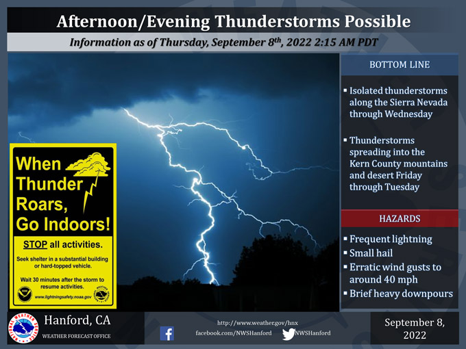
September 8, 2022 - The National Weather Service Hanford Office reports thunderstorms may develop over the higher elevations of the Sierra Nevada this afternoon and continue into the evening.
Expect the threat to continue in these areas until early next week.
Thunderstorm chances spread to the Kern County mountains and desert on Friday, with a daily threat for thunderstorms in these areas continuing until Tuesday of next week.
In addition to dangerous cloud to ground lightning, a few thunderstorms may bring heavy rain, small hail, and wind gusts to around 40 mph.
Area Forecast Discussion
National Weather Service Hanford CA
1246 AM PDT Thu Sep 8 2022
.SYNOPSIS...
An Excessive Heat Warning continues until Friday evening due to
dangerous record-breaking heat. A slight chance of thunderstorms
will continue over the Sierra Nevada each afternoon through
Friday, and then more widespread precipitation is possible this
weekend due to moisture from Hurricane Kay.
&&
.DISCUSSION...
Another hot day is in store today for much of the lower elevations
with another rather warm start to the day, thanks to the strong
ridge of high pressure in place. Record high minimum temperatures
may once again occur at some San Joaquin Valley locations, as
daytime highs reached or exceeded 110 degrees. The Central Valley
is expected to remain just as warm to slightly warmer than the
desert areas of eastern Kern County. For this afternoon, the
probability of temperatures exceeding 105 degrees ranges anywhere
from 40 to 75 percent, depending on location in the San Joaquin
Valley. As for the Kern County desert, the probabilities are
around 25 to 40 percent, except about 75 percent towards China
Lake. The lower Sierra Nevada foothills and West Side Hills will
also remain quite hot today, and expect similar temperatures. As
for Friday, a slight lowering of temperatures is forecast with
lower probabilities of highs at or above 105 degrees (or around 25
to 50 percent). Although, some areas, such as Kern County, may
cool a bit more if clouds begin to increase, as Hurricane Kay,
which is currently off the coast of Southern Baja (near lat/lon
24 deg N, 113 deg W), moves closer to the Southern California
coast.
Temperatures will finally lower back towards seasonal averages for
the weekend. This relief from the extreme heat will initially
come with an increase in moisture from what is now Hurricane Kay
will spread across much of Central California. As Hurricane Kay
moves northward along the coast of Baja, it will continue to
weaken and eventually become a Tropical Storm by early Friday
morning, according to the National Hurricane Center (NHC). This
system is forecast to be a Tropical Depression off the coast of
Northern Baja California by Saturday, per latest projections from
NHC. The best chances for showers and thunderstorms, as well as
the heaviest precipitation, is over the Kern County mountains and
over the Sierra Nevada on Saturday. However, quite a bit of
uncertainty remains regarding how far north the deeper moisture
associated with this system will travel. Otherwise, the entire
Central California interior can expect at least some increased
cloudiness along with a chance of showers. Another round of
showers and thunderstorms will occur mainly over the mountains on
Sunday, although some light showers remain possible elsewhere. In
addition, Kay's low pressure center will continue to weaken off
the coast of Northern Baja due to cooler sea surface temperatures.
Moisture will linger over the higher elevations of the Sierra
Nevada on Monday into Tuesday, so will keep the slight chance of
thunderstorms for these areas. Afterward, a strong trough will
move over the Pacific Northwest and push out any remaining moisture
to the east of our forecast area, or by next Thursday. This trough
may be enough to actually provide slightly below average
temperatures. Finally, we might get a reminder that Autumn will soon
be upon us (after such a prolonged period of extreme heat).
&&
.AVIATION....
Areas of MVFR in smoke from area wildfires and convective
clouds/isolated thunderstorms during the afternoon and evening
over the Sierra Nevada. Otherwise, VFR conditions will prevail in
Central California through at least the next 24 hours.
&&
.AIR QUALITY ISSUES...
On Thursday September 8 2022... Unhealthy for Sensitive Groups in
Fresno... Kern... Kings and Tulare Counties... and Sequoia
National Park and Forest.
Source: NWS
