


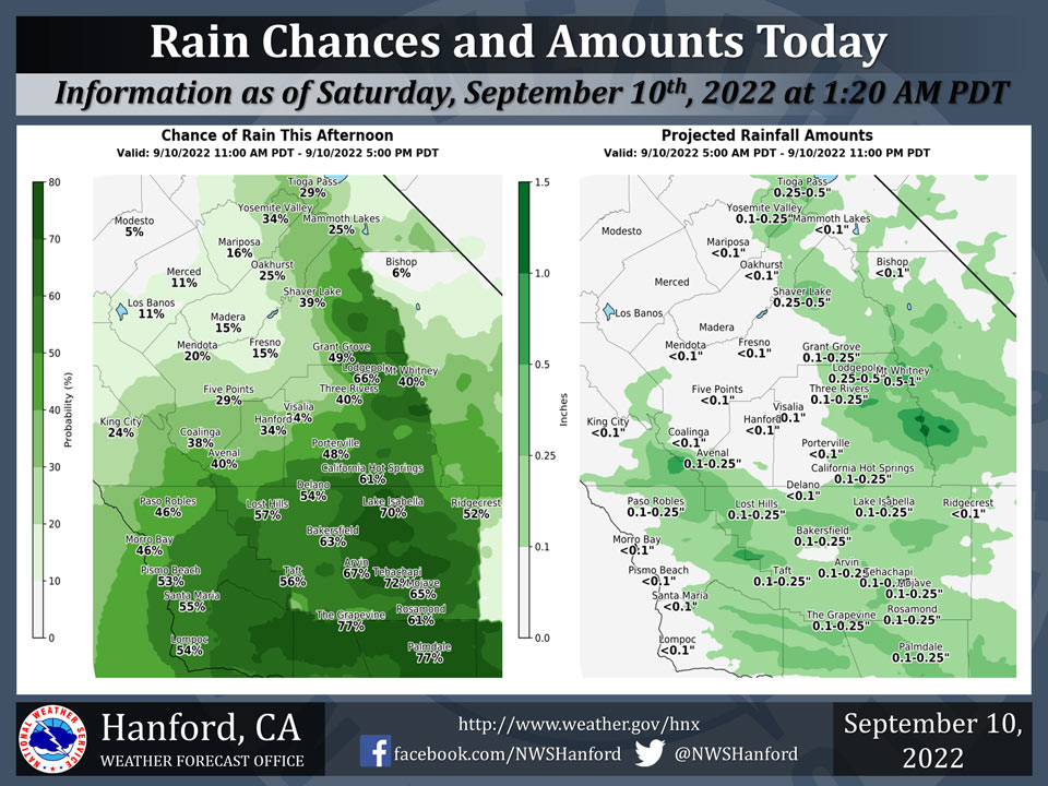
Mariposa has a 16% Chance of Rain on Saturday
Oakhurst has a 25% Chance of Rain on Saturday
Yosemite Valley has a 34% Chance of Rain on Saturday
September 10, 2022 - The National Weather Service Hanford Office reports atmospheric moisture from Post-Tropical Cyclone Kay will be responsible for elevated rain chances this afternoon.Rain chances will decrease from north to south, with the highest probability of precipitation in Kern County and the lowest probability of precipitation in Merced County.
Area Forecast Discussion
National Weather Service Hanford CA
1234 AM PDT Sat Sep 10 2022
.SYNOPSIS...
Atmospheric moisture from Post-Tropical Cyclone Kay will be
responsible for elevated rain chances this weekend. Much cooler
weather is expected this weekend. High temperatures this afternoon
will be twelve to fourteen degrees cooler than yesterday
afternoon. Seasonal temperatures are expected Sunday and Monday,
before a cooling trend Tuesday and Wednesday.
&&
.DISCUSSION...
Post-Tropical Cyclone Kay is located just offshore of the Baja
Peninsula. Post-Tropical Cyclone Kay will turn to the southwest
today, then move in more of a southerly direction Sunday.
Atmospheric moisture from Kay will be responsible for elevated
rain chances throughout Central California this weekend. Rain
chances will decrease from north to south, with the highest
probability of precipitation in Kern County and the lowest
probability of precipitation in Merced County. Rain amounts in the
San Joaquin Valley will generally be less than one tenth of an
inch. The majority of rain will fall this afternoon and Sunday
afternoon. A few strong thunderstorms are possible in the Kern
County mountains and desert and Sierra Nevada both this afternoon
and Sunday afternoon. Much cooler weather is anticipated this
weekend. Maximum temperatures this afternoon will be twelve to
fourteen degrees lower than yesterday afternoon.
Post-Tropical Cyclone Kay will weaken into a trough of low
pressure Monday. This trough of low pressure will progress
eastward over Southern California Monday night into Tuesday. An
Eastern Pacific trough of low pressure will approach the coast of
Northern California Tuesday night. This trough of low pressure
will move eastward over Northern California Wednesday into
Wednesday night, before entering the Great Basin Thursday. Another
trough of low pressure may approach the coast of Northern
California Friday. Seasonal temperatures are anticipated Monday.
A cooling trend is expected Tuesday and Wednesday. By Wednesday
afternoon, high temperatures should be five degrees below normal
for this time of year. Temperatures will remain below seasonal
values Thursday and Friday.
&&
.AVIATION...
MVFR conditions are likely at BFL this afternoon, otherwise VFR
conditions will prevail in the San Joaquin Valley through at least
the next 24 hours. IFR or lower conditions are likely in and near
thunderstorms in the Kern County mountains and desert and Sierra
Nevada this afternoon.
&&
.AIR QUALITY ISSUES...
None.
Source: NWS
