


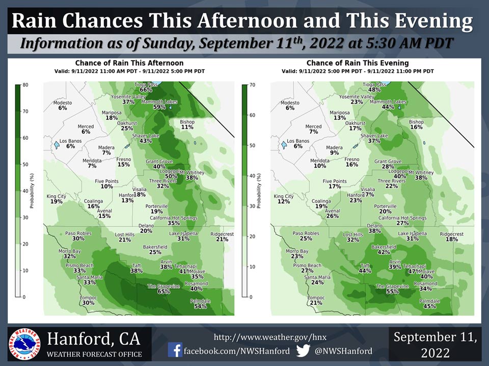
Mariposa has a 18% Chance of Rain on Sunday
Oakhurst has a 25% Chance of Rain on Sunday
Yosemite Valley has a 37% Chance of Rain on Sunday
September 11, 2022 - The National Weather Service Hanford Office reports there is a chance of showers and thunderstorms in the Sierra Nevada and Kern County mountains and desert this afternoon into this evening.There is a slight chance of light rain in the southern portion of the San Joaquin Valley this afternoon into this evening.
Area Forecast Discussion
National Weather Service Hanford CA
231 AM PDT Sun Sep 11 2022
.SYNOPSIS...
Moisture from Post-Tropical Cyclone Kay will continue to bring
a chance of showers and thunderstorms this afternoon and evening.
Chances remain but decrease across the mountains and desert on
Monday and then just across the Sierra on Tuesday. Temperatures
will be a little above average today and Monday then cool to a
little below average by Wednesday and Thursday.
&&
.DISCUSSION...
After a day of widespread showers and thunderstorms, local radar
shows this activity has now diminished with just a few very weak
echoes detected. The source for this activity is the remnants of
post-tropical cyclone Kay, located offshore from northern Baja
California. Rainfall amounts were generally around one-quarter of
an inch or less, but there were some isolated amounts of one-half
to three-quarters of an inch in the mountains.
Little movement is expected with the remnants of Kay today which
will maintain a moist cyclonic flow over southern California. A
repeat of yesterday is likely with more showers and thunderstorms
developing during the afternoon and evening. Hi-resolution models
show convection focused mainly over the mountains during the day
then some spreading west across the San Joaquin Valley during the
evening, mainly in Kern County but as far north as Fresno County.
Lingering moisture will continue to provide a chance of showers
and isolated thunderstorms to the mountains and desert on Monday.
An upper trough moving over the Pacific Northwest on Monday night
will kick the remnants of Kay inland through Tuesday. A dry west
southwest flow aloft will confine precipitation chances along the
crest of the Sierra on Tuesday afternoon. Dry conditions prevail
the remainder of the week and into next weekend.
Temperatures are forecast to generally be around 5 degrees above
average today and Monday. Cooling on Tuesday lowers temperatures
to seasonal levels then around 5 degrees below average Wednesday
and Thursday. Blended model guidance nudges temperatures back up
to climatologically average levels on Friday through the weekend.
&&
.AVIATION...
IFR or lower conditions are likely in and near thunderstorms in
the Kern County mountains and desert and Sierra Nevada Sunday
afternoon and evening. Local MVFR conditions are possible in and
near showers across the San Joaquin Valley Sunday afternoon and
evening.
&&
.AIR QUALITY ISSUES...
None.
Source: NWS
