


RODGERS FIRE
Location: Northwest of Rodgers Canyon and southwest of Pleasant Valley
Elevation: 8,100
Discover date: August 8, 2022
Size: 2,718 acres
Cause: Lightning
Total personnel: 45
No recent fire history; burning in mixed conifer and red fir litter, and dead and down logs. A segment of trail in Rodgers Canyon from Neall Lake to the junction with Table Lake is temporarily closed due to fire activity. The fire continues to show activity in Register Creek as it backs southwest toward the Tuolumne River.
RED FIRE
Location: Between Red Creek and Illilouette Creek
Elevation: 7,800
Discover date: August 4, 2022
Size: 7,823 acres
Cause: Lightning
Total personnel: 225
Fire History: Burning in the 2001 Hoover Fire footprint: burning in red fir, lodgepole pine litter. Trail closures on segments heading out the Illilouette drainage from Glacier Point area to Merced Pass Lake. The Red Fire continues to be most active on its southwest edge, along Lookout Ridge.
Location: Northeast of Aspen Valley
Elevation: 6,200
Discover date: September 4, 2022
Size: 26 acres
Cause: under investigation
Fully suppressed, patrol status
Fire History: Burned within the 2013 Rim Fire footprint in snags and whitethorn
No closures, no evacuations
In the past week, Yosemite Fire and Aviation and partners have responded to multiple new lightning strikes in the park. No closures or evacuations are associated with these incidents at this time. All are/were less than 1/10th acre and have been contained or are being suppressed. More lightning is anticipated in the park today, and it’s likely that more strikes will be detected.
CHIQUITO
Location: Chiquito Pass/Chain Lakes area, near the park’s southeast boundary
Elevation: 9100’
Discover Date: September 10, 2022
TURNER
Location: east of Alder Falls, along Turner Ridge, northeast of the Wawona Road above Alder Creek
Elevation: 6700’
Discover Date: September 10, 2022
EMPIRE
Location: near Empire Meadows, Badger Pass area
Elevation: 6500’
Discover Date: September 10, 2022
LUKENS
Location: near Lukens Lake Trailhead along the Tioga Road.
Elevation: 8,000’
Discover Date: September 10, 2022
WOLF FIRE
Location: Along Tioga Road, east of White Wolf
Elevation: 8000’
Discover Date: September 10, 2022
OBELISK FIRE
Location: East of Starr King Meadow/ west of Lake Obelisk/Mt. Clark
Elevation: 9,750’
Discover date: September 9, 2022
RANCH FIRE
Location: Northeast of Hetch Hetchy Reservoir
Elevation: 4,000’
Discover date: September 7, 2022
ALDER FIRE
Location: North of Alder Creek, northwest of Wawona
Discover date: September 5, 2022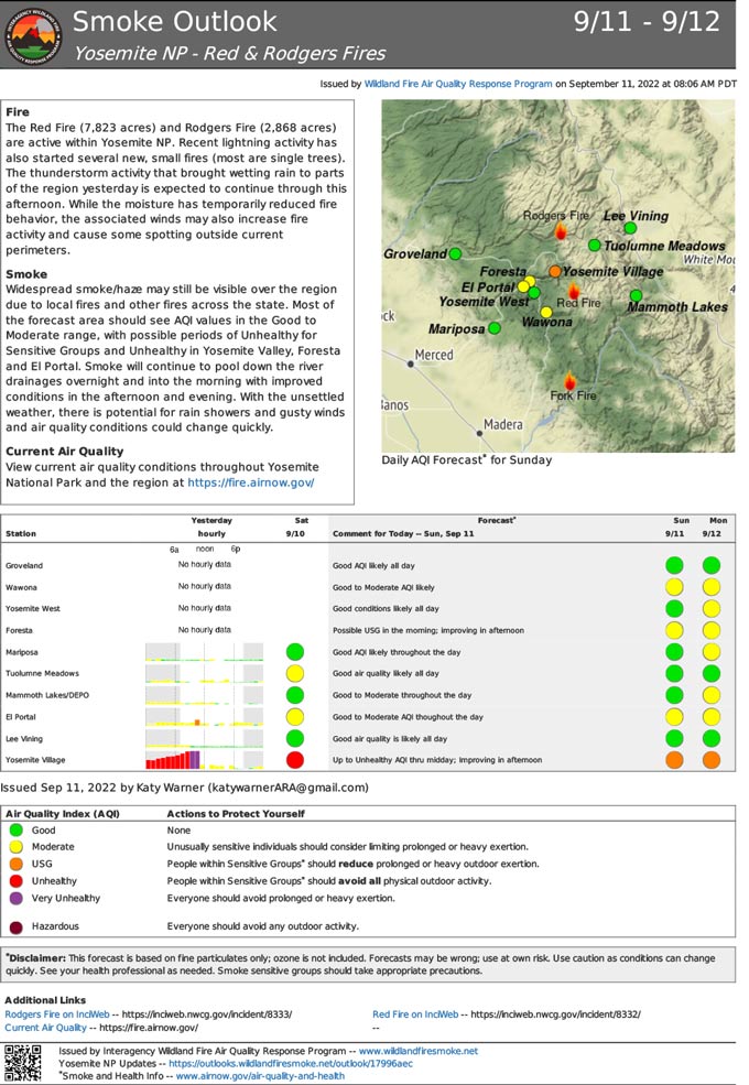
Source: NPS
