


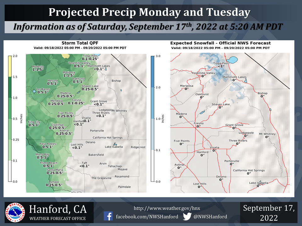
Mariposa Projected Rainfall Totals: 1.00" to 1.50"
Oakhurst Projected Rainfall Totals: 0.50" to 1.00".
Yosemite Valley Projected Rainfall Totals: 0.50" to 1.00".
September 17, 2022 - The National Weather Service Hanford Office reports a storm system will impact Central California late this weekend into early next week.Little to no precipitation is expected in Kern and Tulare Counties.
Snow levels will be around 8,500 feet to 9,000 feet.
Light snow is possible over Tioga Pass Monday morning through Tuesday Morning.
The majority of this precipitation will fall throughout the day on Monday.
Area Forecast Discussion
National Weather Service Hanford CA
400 AM PDT Sat Sep 17 2022
.SYNOPSIS...
Cooler temperatures will continue through the weekend into next
week. A big trough is going to slide into the region Sunday
through Tuesday bringing a chance of rain to the San Joaquin
Valley and a chance of snow around 8,500 feet.
&&
.DISCUSSION...
Pleasant conditions expected to continue across the Central
California Interior this Saturday ahead of a disturbance moving
into the region. After experiencing a heat-wave, max temperatures
across the San Joaquin Valley will only reach into the 80s.
Furthermore, with dew points only reaching into the 50s, muggy
conditions have exited the region as lower humidity values now
exist over the area. In addition, the surface pressure gradient
from KSFO to KLAS increased to just above 5mb. While winds are not
currently reaching windy conditions, the approaching disturbance
into the region will increase winds later this weekend. A change
in the weather is expected as the disturbance continues to drop
toward California with precipitation entering the district as
early as Sunday evening.
Satellite imagery currently has the disturbance and associated
surface cold front off the Pacific Northwest Coast and tracking
southward. While ensemble upper-air analysis has high confidence
that the disturbance will track toward a position off the Bay Area
on Sunday, that same confidence decreases in having precipitation
reaching the Central California Interior on Sunday. Current
ensemble trajectory analysis has the disturbance moving south and
hugging the coast-line until the middle of next week. Initially,
precipitation will be confined to the immediate coast on Sunday
and begin moving ashore around the Monday time frame. The
confidence is possible precipitation increase on Monday as
ensemble upper level wind (jet) analysis shows the introduction of
a jet max moving into the Central California Interior on Monday
along with moisture from a subtropical tap (atmospheric river)
aligning themselves to produce precipitation as even a chance of
local heavy rain may occur on Monday. On the convective side, the
position of the upper low off the California coast will keep the
bulk of the thunderstorm just west of the district. Yet, with the
introduction of the precipitation on Monday, can not rule out
possible isolated thunderstorms over the Northern portions of the
district (north of Kings and Tulare Counties).
Confidence is increasing for the long term as Cluster Analysis
shows possible development of having the trof pattern move through
the Northern Rockies during the mid-week period. Cluster Analysis
is starting to show a stronger signal toward the shift in the trof
solution lifting and moving east toward the end of next week. Yet,
some uncertainty is shown in the magnitude of possible ridge later
next week. While the total cooling is from the next disturbance
has high confidence, the signal toward possible ridge does not
lend itself toward having another heat-wave in the forecast.
Ensembles temperature analysis shows the extended period reaching
back toward seasonal normal values with unsettled conditions
persisting until ridging enters the picture to dry out the region.
&&
.AVIATION...
VFR conditions will prevail in Central California through at
least the next 24 hours.
&&
.AIR QUALITY ISSUES...
None.
Source: NWS
