


California and National Drought Summary for September 20, 2022
Summary
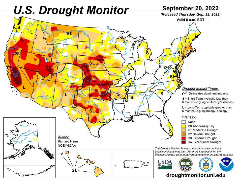
September 22, 2022 - An upper-level ridge dominated the central contiguous U.S. (CONUS) during this U.S. Drought Monitor (USDM) week (September 14-20). It was bracketed by an upper-level trough which moved out of the Northeast early in the week, and a Pacific upper-level trough that moved into the West as the week progressed. Pacific weather systems moved across the northern states between the troughs. This pattern resulted in above-normal precipitation across much of the West and parts of the Northeast. Fronts associated with the Pacific systems triggered showers and thunderstorms across parts of the central and northern Plains to Mid and Upper Mississippi Valley. For the rest of the CONUS, a large dry air mass covered much of the southern Plains and East throughout the week. Rain occurred along a stationary front draped across Florida that was associated with the southern edge of the air mass, but for much of the South, Southeast, Mid-Atlantic, and Midwest regions it was a dry week. Temperatures averaged warmer than normal across the Plains to Great Lakes, and cooler than normal across much of the West, Southeast, and northern New England. A tropical system brought heavy rain to Puerto Rico and the Virgin Islands. Drought or abnormal dryness expanded or intensified across northern parts of the West, from the central and northern Plains to the Mid- and Upper Mississippi Valley, and over parts of the Mid-Atlantic coast. Drought or abnormal dryness contracted where it rained, especially in parts of Florida, New Mexico, and the Northeast, in a swath from Iowa to Illinois, and across Puerto Rico.
Northeast
Two inches or more of rain fell across northern parts of New York and New England; half an inch or more fell over areas to the south of this region and across eastern Maine and parts of West Virginia; and less than half an inch occurred over Pennsylvania and New Jersey. Little to no rain was measured over much of Maryland, Delaware, and southern New Jersey. The rain was enough to trim D0-D2 in parts of New York and New England, and resulted in the removal of D3 from Rhode Island and southern Massachusetts, although the D3 around Boston remained. D0-D2 were also trimmed in Pennsylvania, New Jersey, Delaware, and Maryland.
Southeast
A stationary front triggered rain across the southern half of Florida for much of the week, with widespread 2+ inch total rainfall amounts. This resulted in contraction of the D0 and D1 in southern Florida. But the Florida panhandle and most of the rest of the Southeast region had no rain this week. With cooler-than-normal temperatures, evapotranspiration rates were low. Spots of D0 were added to Alabama and adjacent parts of the Florida panhandle and southwest Georgia due to wilting pastures and lowering streams. D0 expanded and D1 was added to eastern North Carolina and Virginia where soil moisture, streamflow, and groundwater levels decreased and crops were showing stress.
South
A few areas of the Gulf Coast and western Texas received up to half an inch of rain this week, but the South region was, for the most part, dry with no rain falling. Moderate and severe drought contracted slightly in a couple spots in southern Texas, and abnormal dryness and moderate drought expanded in a couple other areas of the Lone Star State and abnormal dryness expanded in Tennessee. But the biggest changes occurred in Oklahoma and Arkansas. D1-D4 expanded in Oklahoma and D0-D2 expanded in Arkansas. Soils continue to dry and groundwater and stream levels are low. According to U.S. Department of Agriculture (USDA) statistics, 82% of Oklahoma’s topsoil moisture is short to very short of moisture (dry to very dry). The only drier years in mid-September in data going back to 2010 were 2011 and 2012, which were very bad drought years. All states in the region except Louisiana and Mississippi had half or more of the topsoil moisture short or very short of moisture. Almost 70% of the pasture and rangeland in Oklahoma was in poor to very poor condition. Ponds in Oklahoma are drying up and 63% of the cotton crop is in poor to very poor condition.
Midwest
Two inches or more of precipitation fell this week in a streak across southern Iowa to central Illinois, and over northern parts of the Midwest region. Other areas had up to half an inch of rain, while southern parts (southern Missouri to Kentucky) and parts of the Great Lakes had little to no rain. D2-D3 contracted in southeast Iowa to adjacent Illinois and northeast Missouri where the heaviest rains fell. D0-D1 contracted in Illinois and D0 shrank in parts of Indiana and Minnesota. But the bigger change was expansion of drought in several Midwestern states. D0-D3 grew in Missouri, D0-D2 expanded in Minnesota and Wisconsin, and D0-D1 expanded in parts of Michigan and Illinois.
High Plains
Parts of the High Plains region had rain while other parts were dry. Up to two inches fell locally in parts of several states. Especially dry areas occurred in parts of the Dakotas, Montana, Kansas, and Colorado. The lack of rain was accompanied by unusually hot temperatures regionwide, which increased evapotranspiration and accelerated the drying of soils. The drying soils and dry ponds and waterholes led to extensive expansion of D0-D2 in North Dakota and Montana, and D0-D4 in South Dakota and Kansas. Groundwater levels are low with wells in Wichita, Kansas, going dry. According to media reports, a water emergency developed in Caney, a town in southeast Kansas, when water stopped flowing over the Little Caney River’s dam; there are 6 weeks of water supply left. D1 and D2 expanded in parts of Colorado, and D3 expanded in southeast Wyoming while other parts of the state saw contraction of D0 and D1. Nebraska also had some contraction of D2, but expansion of D1-D3 in other parts of the state. According to USDA statistics, all states in the region had half or more of the topsoil moisture short or very short of moisture. In Nebraska and Kansas, three-fourths of the pasture and rangeland was in poor to very poor condition, while the value was 50% for Colorado, 55% for South Dakota, and 58% for Montana.
West
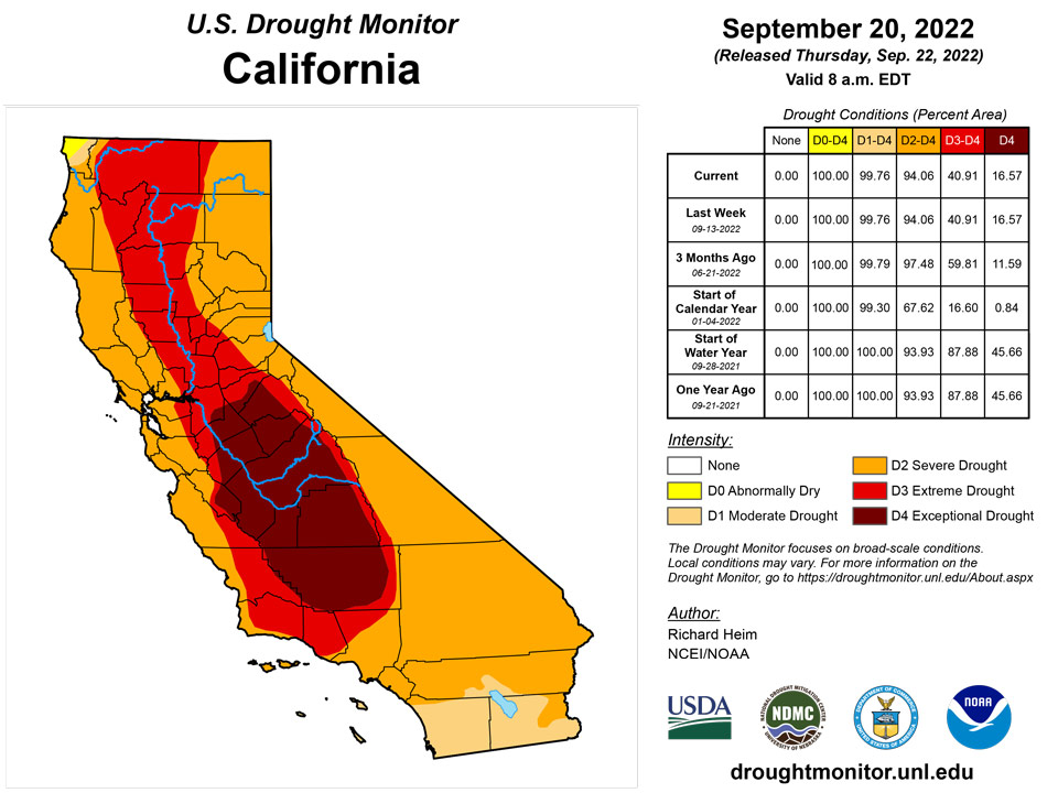
Pacific weather systems dropped locally 2 or more inches of rain across parts of central and northern California, and over local areas of the Great Basin and southern New Mexico. Half an inch or more of precipitation occurred over large parts of the interior West. Other parts, especially much of Washington, Oregon, northern Idaho to northwestern Montana, and southern California to parts of New Mexico, were dry this week. Groundwater continues low and many reservoirs were still very low to near record low. The water levels in most reservoirs in New Mexico are well below average. The August 2022 total combined end-of-month storage of 12 large reservoirs in the state ranked among the three smallest August totals since 1990. The precipitation that fell this week did little to make up deficits that have built up over the last 5 years, so little improvement was made on this week’s map over the areas that received precipitation. One exception was southern New Mexico and adjacent Arizona, where D1-D3 contracted in the wetter areas this week that have also benefited from a wet monsoon season. In northern parts of the West region, D0 was added to western Washington and northwest Oregon where streams were low, very warm temperatures increased evapotranspiration and continued to dry soils, and precipitation was below normal for the last 3 months. D1 expanded in northern Idaho where several indicators reflected the dry conditions of the last 3 months, and several dozen large wildfires continued to blaze. According to USDA statistics, all of the states in the region except California, Nevada, and Arizona had half or more of their topsoil moisture short or very short of moisture.
Caribbean
Hurricane Fiona dropped very heavy rainfall across Puerto Rico and the Virgin Islands that caused widespread flooding and power outages, especially on Puerto Rico. Rainfall totals ranged from 6 inches over northwest Puerto Rico to over 20 inches in southeast parts of the island. The rain was enough to erase deficits that have built up over the last 12 months, so all D0 and D1 were removed from Puerto Rico.
Heavy rainfall across the U.S. Virgin Islands was observed this week due to Hurricane Fiona. On St. Thomas, 2.5 inches of rain was reported at Cyril E. King Airport. An increase in the water level was also observed this week (due to recent rain), so the abnormal dryness or drought of the past few weeks has significantly improved across the island. St. John received heavy rainfall that improved short-term severe drought to abnormal dryness this week. At Windswept Beach, 3.75 inches of rain was reported this week. The depth of the water level has also increased due to recent rain. Similarly, St. Croix (Henry Rohlsen AP) reported 6.25 inches of rain this week. Because of the recent rains, severe drought conditions have improved. Despite a slight increase in the water level, due to long-term drought conditions, the ground water is still well below normal. Thus, St. Croix is in moderate drought because of the long-term hydrologic impact.
Pacific
Western Alaska was hit by heavy rain and wind from a Pacific weather system this week. The system was strengthened when the remnants of Typhoon Merbok merged with it a few days earlier. Eastern interior, southern coastal, and panhandle areas were drier than normal this week. The D0 in eastern interior Alaska expanded slightly due to little to no precipitation falling this month.
Portions of Hawaii have been getting rainfall, while others have remained generally dry, so this week had a mixture of changes. D2 was pulled back in northeast Kauai and contracted on southern Oahu. D0 contracted on eastern Molokai. On Maui, D1 was pulled back in the southwest but D3 added in the south. D2 was expanded D2 and D3 added in northern portions of the Big Island.
This week Pago Pago reported 0.76 inches of rain (one day missing). Last week, 0.67 inches of rain was observed at Pago Pago. Siufaga Ridge and Toa Ridge (both NPS in American Samoa) observed 0.79 and 0.37 inches of rain, respectively. Thus, American Samoa experienced abnormally dry conditions in the past week.
Dry conditions prevailed this week across the Republic of Palau. Palau IAP (Airai) and Koror COOP station reported 0.47 and 0.49 inches of rain, respectively. However, August was wet with over 13 inches of rain. In addition, 2.03 inches of rain fell last week, so the area remained free of drought.
Generally, drought-free conditions continued across the Mariana Islands this week. Wet conditions continued at Rota, which received 3.86 inches of rain this week. This week’s report on Saipan shows rainfall amounts observed on IAP (manual gauge), ASOS, and NPS of 2.94, 0.76, and 0.37 inches, respectively. Similarly, Guam received 5.75 inches of rain to remain drought free. In contrast, even though July and August were wet months (14.16 and 10.55 inches of rain, respectively), drier conditions prevailed at Saipan in the past two weeks (i.e., only 0.03 and 0.02 inches of weekly rain were reported).
Short- and long-term moderate drought continued this week on Kapingamarangi, where 0.78 inches of rain was reported. Wet conditions have prevailed at Pohnpei in the past few months. This week, only 1.48 inches of rain was reported (with one day missing). On Pingelap, 3.45 inches of rain was reported this week, resulting in a continuation of wet conditions. On Yap, only 1.47 inches of rain was reported (with one day missing). Even though the past few months were wet at Yap, drier conditions prevailed in the past three weeks (0.03 to 1.6 inches of rain reported), leading to short-term abnormal dryness. On Ulithi, dry conditions prevailed in the past four weeks (i.e., 0.65”, 0.90”, and 0.49” of rain reported in the past three weeks). This week, only 0.93 inches of rain (with one day missing) was reported, so short-term abnormally dry conditions remained. The rainfall reported at Woleai this week was 0.90 inches with one day missing. Because Woleai had wet conditions in last week (i.e., 2.58 inches), it remained free of dryness. At Chuuk, only 0.56 inches of rain was observed this week with one day not yet accounted for. However, Chuuk reported 4.35 and 5.31 inches of rain in the last two weeks, respectively, and remained free of dryness. Dryer than normal conditions were observed in the past few weeks at Lukunor. This week only 0.12 inches of rain was reported on Lukunor (with two days not yet accounted for), resulting in continuation of short-term abnormal dryness. On Nukuoro, only 0.70 inches of rain was reported this week, with one day missing. However, Nukuoro remained free of drought or abnormal dryness since 5.12 inches of rain was reported last week. No depiction was made for Fananu, as data from there are missing.
Most of the Marshall Islands remained free of drought or abnormal dryness this week, except for Wotje. On Wotje, 1.78 inches of rain was reported this week. In addition, it has been dry in the past two weeks (i.e., 1.79 inches of rain last week and no rain a week before), leading to the development of abnormal dryness. Majuro and Mili both had wet two-week periods, with 2.63 and 3.58 inches of rain, respectively.
On Ailinglapalap, 5.84 inches of rain fell this week, so drought-free conditions continued. Kwajalein received 1.63 inches of rain this week and 2.51 inches last week, so it remained drought-free. Jaluit reported 2.11 inches of rain this week to remain free of dryness. No depiction was made for Utirik due to missing data.
Looking Ahead
A strong upper-level low pressure system will move across the northern half of the CONUS during September 22-27 while high pressure generally dominates the southern half of the country. By the end of the period, the upper-level circulation pattern will consist of a ridge over the West and a trough over the East. This scenario will result in above-normal temperatures in the West and South with below-normal temperatures in the Northeast. Half an inch or more of precipitation, locally up to 2 inches, is forecast to fall from the Four Corners states to the northern Rockies and eastward to the central and northern Plains, as well as across parts of the Great Lakes, much of the Northeast, and over southern Florida. Half an inch or less is expected over Oregon, the Mid to Upper Mississippi Valley, the Tennessee Valley to Appalachian chain, and Mid-Atlantic Coast. Little to no precipitation is predicted for Washington, California, and Nevada in the West, across the southern Plains to Southeast, and over parts of the Midwest. For September 28-October 5, the western ridge and eastern trough pattern is expected to persist. Odds favor warmer-than-normal temperatures across the West to Mississippi Valley and the Alaskan panhandle, with cooler-than-normal temperatures from the Northeast to southern Appalachians and over southwest Alaska. The circulation pattern will likely result in below-normal precipitation from the Pacific Northwest to Northeast, across the Great Plains to Mississippi Valley, and over the Ohio Valley as well as western Alaska. Odds favor above-normal precipitation over the coastal Southeast, the eastern half of Alaska, and a small area in the Four Corners states.
Author(s):
Richard Heim, NOAA/NCEI
Tsegaye Tadesse, National Drought Mitigation Center
Dryness Categories
D0 Abnormally Dry—used for areas showing dryness but not yet in drought, or for areas recovering from drought.
Drought Intensity Categories
D1 Moderate Drought
D2 Severe Drought
D3 Extreme Drought
D4 Exceptional Drought
Drought or Dryness Types
S Short-term, typically less than 6 months (agriculture, grasslands)
L Long-term, typically more than 6 months (hydrology, ecology)
SL Area contains both short- and long-term impacts
Source: National Drought Mitigation Center
