


California and National Drought Summary for September 27, 2022
Summary
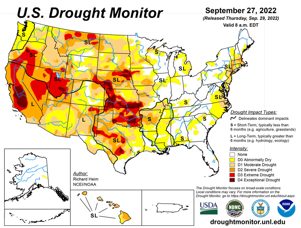
September 29, 2022 - Two upper-level weather systems danced across the contiguous U.S. (CONUS) during this U.S. Drought Monitor (USDM) week (September 21-27). One partner of the pair was an upper-level low pressure trough which twirled from the West Coast to the northern Plains then migrated to the Northeast. The other partner was a high pressure ridge. As they did a kind of do-si-do, the ridge swung from the southern Plains to the western CONUS. Other players danced at the periphery – Hurricane Fiona moved across the Canadian Maritime Provinces, spreading rain over New England at the beginning of the week, while Hurricane Ian brought rain and wind to southern Florida as it bore down on the state just as the week ended. The high pressure ridge brought hot temperatures to the southern states at first, then to the West later in the period. The trough generated a storm track across the northern states, then sent a large cold front into the Southeast as the period ended. Monsoon showers joined in over the Southwest in these waning days of summer. The end result was a weekly precipitation pattern that was wetter than normal over parts of the West, southern Plains, Great Lakes, Northeast, and southern Florida. The rain missed large parts of the West, which received little to no precipitation, and much of the Plains, Mississippi to Ohio Valleys, and Southeast to Mid-Atlantic states were drier than normal as well. Temperatures for the week averaged warmer than normal over the southern Plains to Lower Mississippi Valley and across parts of the Southwest and Northwest. The week ended up cooler than normal from the northern Plains to Northeast and into parts of the Southeast. The hot temperatures and continued dry conditions, especially in the South, further dried soils. According to the U.S. Department of Agriculture (USDA), national topsoil moisture rated very short to short (dry or very dry) reached 54%, a high for the year to date and very close to the recent maximum of 56% achieved on October 18, 2020. This is the third year in a row that a peak greater than 50% has occurred. Drought and abnormal dryness contracted where it rained in the Southwest, Northeast, and southern Florida. Drought and abnormal dryness expanded where it didn’t rain, including the Northwest, Great Plains to Mississippi Valley, and Mid-Atlantic states.
Northeast
Most of the Northeast region received half an inch of rain or more for the week, with some areas experiencing over 2 inches. The rain this week and previous weeks improved streamflows, ground water, soil moisture, and Standardized Precipitation Index (SPI) values, resulting in a broad one-category contraction of abnormal dryness (D0) and moderate to extreme drought (D1-D3) in New England. Improvement also occurred in New York, New Jersey, and Pennsylvania, although D1 expanded a little in southern New Jersey.
Southeast
Rain earlier in the week, and Hurricane Ian late in the week, conspired to dump half an inch to locally over 5 inches of rain over the southern half of Florida. To the north, a mostly dry cold front triggered showers over parts of Alabama to Virginia, but most of the Southeast region was dry this week. Soils continued to dry, with USDA reports indicating 50% of the topsoil moisture in North Carolina classified as short or very short (dry or very dry), with the value 48% for Georgia. D0 expanded in most states as 1-month rainfall deficits mounted, and D1 expanded in the Carolinas and Virginia. But the rain in southern Florida resulted in a 1-category improvement to the D0-D1 there.
South
About half an inch of rain fell across a few parts of Texas, Mississippi, and Tennessee, but otherwise the South region was dry this week. Hot and mostly dry conditions were observed this past week especially across the Arkansas-Louisiana-Texas area, with near record high temperatures recorded each day as readings neared the century mark. This marks nearly the third straight week with near cloud-free conditions, with below normal relative humidity for this time of year yielding high evaporation rates. Grounds have quickly dried out over much of the area, which has yielded an increased frequency of small wildfires especially across eastern Texas and portions of southeastern Oklahoma. In southeast Oklahoma, hydrological impacts were increasing as Broken Bow Lake was over 11 feet below conservation pool stage, with Pine Creek Lake down about 5 feet. USDA reports indicated 91% of the topsoil short or very short of moisture in Oklahoma. Rapid drying of soils has occurred in Arkansas, with the USDA statistic exploding from 40% on September 11 to 58% on September 18 and reaching 88% on September 25. According to news reports, fierce heat and drought in Arkansas have limited hay and grass growth; August rains allowed farmers to grow some hay, but farmers still do not have enough to get through the winter. Dried ponds, cracked earth, and no forage (pasture) for farm animals were common, especially in western Arkansas. D0 spread across much of Louisiana, Mississippi, and western Tennessee, with D0-D3 growing in Arkansas and D2-D4 expanding in Oklahoma. D0-D4 expanded in parts of northern, eastern, and central Texas, while contraction of D0-D1 occurred along parts of the Rio Grande River.
Midwest
Half an inch or more of rain fell across parts of the Mississippi Valley and much of the Great Lakes, while much of the Ohio Valley and large parts of the Mid-Mississippi Valley had less than a fourth of an inch of precipitation. USDA statistics showed 63% of the topsoil short or very short of moisture in Missouri, with the value 43% in Iowa and Kentucky. In central Missouri, the COOP station located on the University of Missouri-Columbia campus has received 6.46 inches of precipitation for the period June 2-September 27, 2022 (118 days); this is 11.06 inches below normal, 37% of normal, and the driest similar period for the station in 23 years. In southwest Missouri, a rancher reported dried ponds and creeks, no forage (pasture) (he has been feeding hay since July), and rapidly declining groundwater (dried wells required digging deeper wells). Marshes were drying up in west-central Wisconsin. D0 or D1 expanded some and contracted some in Illinois, Indiana, and Ohio, while D0 expanded across much of Kentucky. D0-D1 expanded in Minnesota, D0-D2 grew in Wisconsin, D0-D3 expanded in Iowa, and D0-D4 grew in Missouri.
High Plains
Half an inch or more of rain fell across parts of North Dakota and Wyoming, with locally an inch or more in parts of Colorado and Nebraska and over 2 inches in parts of Kansas. But most of South Dakota had less than a fourth of an inch of rain as did large parts of Nebraska and Wyoming. More than 70% of the topsoil moisture was short or very short in Kansas, Nebraska, South Dakota, and Wyoming, according to USDA statistics, with the numbers 67% in Colorado and 54% in North Dakota. According to media reports, heat and drought limited forage production in Nebraska and other drought-stricken areas, forcing cattle producers to weigh hay supplies against herd size for the winter. Many growers chopped drought-damaged crops for silage. D0-D2 were pulled back in a few parts of Wyoming, D0-D3 were trimmed in parts of Kansas and Colorado where the heaviest rains fell, and D3 was deleted in western South Dakota. But drought or abnormal dryness expanded in other parts of the High Plains region states, including North Dakota (D0-D2), Colorado (D0-D1), Nebraska (D2-D3), South Dakota (D0-D4), and Kansas (D0-D2 and D4).
West
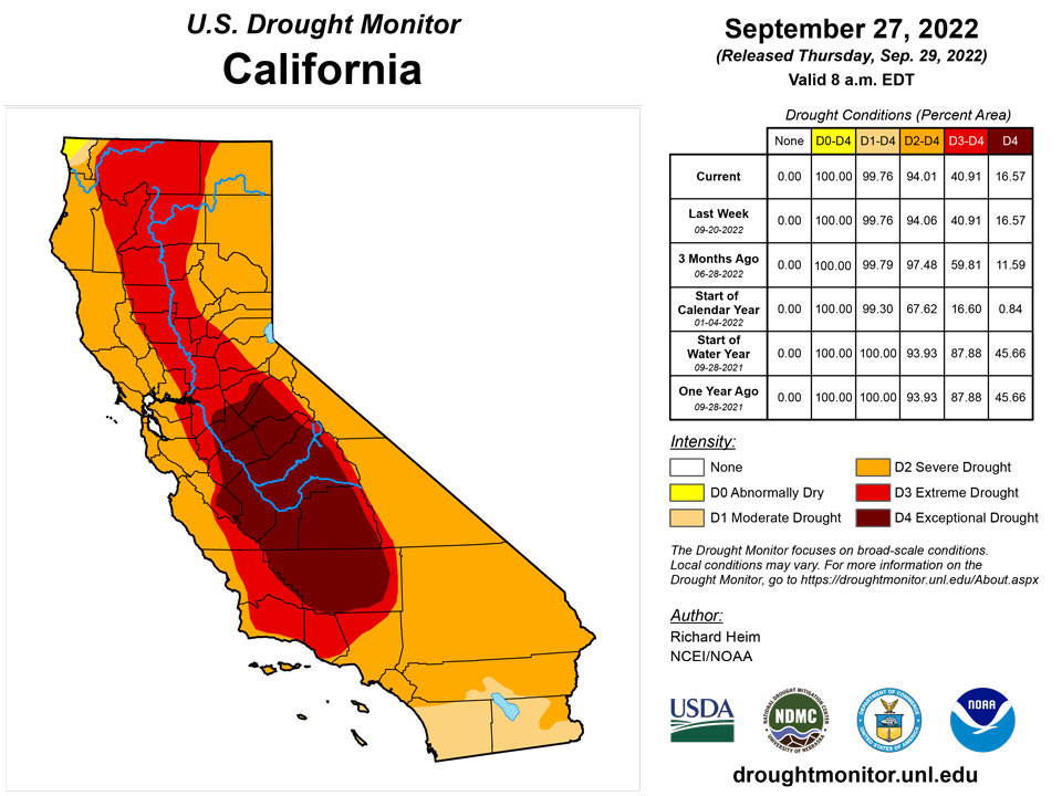
Monsoon showers dumped half an inch to locally 2+ inches of rain over parts of the Four Corners states, while a Pacific weather system gave parts of the northern Rockies half an inch to locally 2+ inches of precipitation. A few spotty areas of California, Nevada, Oregon, and eastern Montana received locally half an inch of precipitation. The rest of the West was dry. Low streams, dry soils, and a combination of hot temperatures with little to no rain prompted expansion of D0 across coastal Washington and Oregon. These conditions contributed to ponds drying up in central to eastern Washington where D1 expanded. In Oregon, most large reservoirs nearly empty to less than 10% full due to the prolonged dry weather. USDA reports indicated 95% of the topsoil moisture was short or very short in Montana, with the values 71% in Oregon and 65% in Washington. D0-D3 expanded in central to eastern Montana. Above-normal rain during this year’s monsoon season has resulted in contraction of drought in the Four Corners states. The rains this week contracted D1-D2 in Arizona and New Mexico. But 5 to 20 years of drought have brought many large reservoirs to very low levels, including Lake Powell which was still only 25% full and Elephant Butte which was 5% full. It will take several years of above-normal precipitation, and springtime melt of many winters of heavy mountain snowpack, to bring these reservoir levels back up.
Caribbean
With soils saturated from Hurricane Fiona’s rains of last week, no change was made to the drought-free depiction in Puerto Rico.
St. Croix (Henry Rohlsen AP) reported 0.26 inches of rain this week. Because of the recent rains, the depth of the water level at St. Croix has increased. However, it has not yet recovered from the long-term (hydrologic) drought. Thus, St. Croix is still in moderate drought because of the long-term drought. Similarly, on St. John, at Rafe Boulon (VI-SJ-3: Windswept Beach), 1.62 inches of rain was reported this week. The depth of the water level has also increased due to recent rains. However, St. John remained in the abnormally dry category because of the long-term dry conditions. In contrast, St. Thomas (Cyril E. King Airport) observed only 0.43 inches of rain, but due to recent rains, the depth of water increased. Thus, St. Thomas remained free of dryness or drought.
Pacific
A small spot of D0 continued in eastern Alaska where no change was made to the depiction this week.
In Hawaii, a weak trade-wind flow this week resulted in dry weather over some parts of the islands while allowing afternoon heating to trigger convective showers over other parts. D2 expanded on Kauai, 1-cat improvement was made on the southwest side of Maui (southwest flank of Haleakala volcano), and D2 expanded on the windward side of the Big Island and D1-D2 contracted on the lee side.
As reported by drought expert Brandon Bukunt of NOAA, the large-scale atmospheric/oceanic pattern in the last month or so has been La Niña-like conditions, with all tropical development and monsoon troughing anchored north of the islands of Micronesia. This overall pattern, in the middle of what would best be described as "wet season" for most parts of the region, keeps most of the islands in a drier regime, particularly the islands of western and central Micronesia. On Yap and Ulithi, the monsoon paid a brief visit recently. This week, 2.95 inches of rain was reported on Yap. However, below-normal rains were reported in the past three weeks, so Yap remains abnormally dry. On Ulithi, only 2.55 inches of rain was reported this week. Dry conditions prevailed in the past five weeks, so short-term abnormal dryness continues. Kapingamarangi has been dry in the past few weeks, with only 0.03 inches of rain reported this week (with three days missing), and therefore it remains in short- and long-term moderate drought. Reported rainfall on Lukunor was only 1.13 inches this week (with two days missing). Drier-than-normal conditions were observed in the last four to five weeks. Thus, Lukunor is degraded to short-term moderate drought this week.
Wet conditions have prevailed at Pohnpei in the past few months. This week, only 1.99 inches of rain was reported (with three days missing). On Pingelap, no rain was reported this week (with 3 days missing). However, wet conditions prevailed in the past three weeks, allowing the island to remain drought free. On Woleai, 3.58 inches of rain was reported this week, with two days missing. Thus, the wet conditions continue at Woleai. At Chuuk, 2.92 inches of rain was observed this week, with one day not yet accounted for, so Chuuk remains free of dryness. On Nukuoro, 3.18 inches of rain was reported this week (with three days missing), allowing the island to remain free of drought or abnormal dryness. No depiction was made for Fananu, as data from there are missing.
Pago Pago reported 0.87 inches of rain this week. Last week, 0.76 inches of rain was observed at Pago Pago. Siufaga Ridge (NPS in American Samoa) observed 1.81 inches of rain. Thus, American Samoa continued experiencing abnormally dry conditions.
Dry conditions have continued this week across the Republic of Palau. Palau IAP (Airai) and Koror COOP station observed 1.90 and 1.74 inches of rain, respectively. This is the second week with less than normal rain. However, because over 14 inches of rain fell on Koror in August, the area remains free of drought for this week.
The drought-free conditions have continued across the Mariana Islands this week. Rainfall reported on Guam was 2.16 inches, allowing the island to remain free of dryness or drought. Wet conditions continued at Rota, which received 3.35 inches of rain this week. This week 2.01” of rain was observed at Saipan. In addition, the amounts of rainfall observed on Saipan IAP (manual gauge), ASOS and NPS were 2.46, 2.01 and 1.96 inches, respectively. Thus, Saipan remains drought free this week.
Except for Wotje, the Marshall Islands remained free of drought or abnormal dryness this week. On Wotje, 1.24 inches of rain was reported this week, resulting in a continuation of short-term abnormal dryness. On Ailinglapalap, 1.35 inches of rain was observed this week. However, because of the wet conditions in the past few months, it remained drought free. Kwajalein reported 0.06 inches of rain this week and 1.63 inches last week. This week is the second consecutive week with less than normal rainfall. However, because of the wet conditions in the past few weeks, Kwajalein remained in the status quo of drought-free conditions for this week. Wet conditions continue at Majuro and Mili, reporting 3.85 and 4.56 inches of rain, respectively. Jaluit reported 1.22 inches of rain with one day missing this week but remained drought free due to wet conditions in the past few weeks. No depiction was made for Utirik due to missing data.
Looking Ahead
During the two days after the Tuesday morning cutoff time for the USDM, Hurricane Ian made landfall across Florida and an upper-level trough moved across the Northeast, with these systems bringing rain to these areas, while another Pacific trough moved into the Pacific Northwest. Dry high pressure dominated most of the rest of the CONUS. For the period September 29-October 4, the Pacific trough will move across the Pacific Northwest and northern to central Rockies, giving these regions 0.5-1.5 inches of rain with locally up to 2 inches. The remnants of Ian will be drawn over the Southeast, spreading a large area of 1-5 inches of rain across the Southeast to Mid-Atlantic states, with locally over 10 inches in parts of Florida. Ian’s rain will stretch into the eastern Tennessee Valley and southern New England, where up to an inch of rain is expected. Little to no precipitation is forecast for the rest of the CONUS where high pressure ridging will dominate. Temperatures are predicted to be warmer than normal in the West to Great Plains and cooler than normal in the Southeast to Mid-Atlantic states. For the period October 4-12, odds favor above-normal precipitation across most of Alaska and in the Four Corners states, with below-normal precipitation over the Alaska panhandle, northern portions of the West, and much of the Plains to East Coast. The West and Alaska panhandle are expected to get wetter as the period progresses. Odds favor warmer-than-normal temperatures for most of Alaska and most of the CONUS, except the period may begin cooler than normal along the East Coast.
Author(s):
Richard Heim, NOAA/NCEI
Tsegaye Tadesse, National Drought Mitigation Center
Dryness Categories
D0 Abnormally Dry—used for areas showing dryness but not yet in drought, or for areas recovering from drought.
Drought Intensity Categories
D1 Moderate Drought
D2 Severe Drought
D3 Extreme Drought
D4 Exceptional Drought
Drought or Dryness Types
S Short-term, typically less than 6 months (agriculture, grasslands)
L Long-term, typically more than 6 months (hydrology, ecology)
SL Area contains both short- and long-term impacts
Source: National Drought Mitigation Center
