


California and National Drought Summary for October 25, 2022
Summary
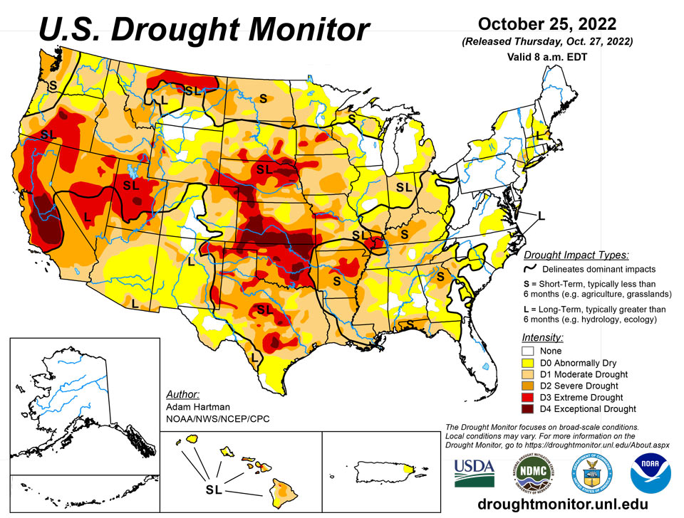
October 27, 2022 - A large shift in the weather pattern occurred this week across the lower 48 states. Early in the week, low pressure exited the Great Lakes region, allowing temperatures to gradually moderate during the latter half of the week across portions of the eastern contiguous U.S. (CONUS). In the western CONUS, high pressure broke down as a strong storm system moved into the Pacific Northwest heading into the weekend. As this storm system moved eastward into the Great Plains through the weekend and leading up to Tuesday, October 25, many locations across the western and central CONUS experienced above-normal precipitation, with cooler than normal temperatures in the system’s wake. However, with surface high pressure early in the week followed by southerly flow ahead of the storm system, warm temperatures dominated much of the central CONUS for the week as whole, with above-normal average temperatures also extending northeastward into the Great Lakes and Northeast. Unfortunately, given the expanse of drought and abnormal dryness across the U.S., antecedent dryness led to another week of degradations for many not receiving rainfall, even in areas where temperatures were cooler than normal this week. Warm conditions and high winds further exacerbated conditions in drier areas across the Great Plains. Fortunately, in areas seeing the heaviest rainfall amounts, particularly across the Southern Plains and Ozarks, some improvements were also warranted.
Northeast
A storm system moving exiting the Great Lakes early in the week and a coastal storm moving northward along the Eastern Seaboard toward the end of the week resulted in another round of improvements to long-term drought conditions across parts of New England and the Mid-Atlantic. In addition to several locations observing above-normal precipitation for the week, a persistent wet pattern in recent weeks has warranted targeted improvements in areas not receiving above-normal precipitation, as long-term drought indicators have continued to improve. Conversely, parts of western New York have experienced several weeks of dryness, resulting in 30-day standardized precipitation indices (SPIs) to drop significantly. Average stream flows and soil moisture have also steadily declined over the past 30 days across areas that are degraded to the abnormally dry (D0) depiction this week in western New York.
Southeast
The exiting storm system in the Great Lakes followed by a coastal storm system that developed off the coast of the Carolinas kept temperatures cooler than normal for the Southeast this week. In addition, high pressure dominated the region during this time, resulting in a dry conditions throughout the region. Given the antecedent dryness in recent weeks and this week’s below-normal precipitation, widespread 1-category degradations were warranted this week. The southern Appalachians are experiencing some of the worst drought conditions presently (D2 – severe drought), as shallow soil moisture has fallen below the 10th percentile of the historical distribution and 7-day average stream flows are continuing to fall near and below the 10th percentile. Locals are reporting crop stress, poor pastures, and several producers have already started supplemental feeding of livestock in some locations. The planting of winter wheat has also been delayed due to the recent dryness.
South
A storm system moving out of the Rockies and intensifying across the Southern Plains dropped in excess of 2 inches of rainfall in a large swath from northeastern Texas to the western Ozarks, warranting 1-category improvements across many of these locations. In surrounding areas that received heavier precipitation amounts, improvements were more targeted in nature, as amounts were not enough to eliminate 90-day deficits. Farther eastward, from the Lower Mississippi Valley to the Tennessee Valley, antecedent dryness and a drier than normal week resulted in another round of widespread 1-category degradations.
Midwest
In similar fashion as the Southern Region, antecedent short-term (30 to 60-day) dryness has resulted in the widespread expansion of abnormally dry (D0) and moderate (D1) to severe (D2) drought conditions. Given the much of the region experienced above-normal temperatures and below-normal precipitation again this week, it warranted another round of 1-category degradations, particularly across the Ohio Valley. Soil moisture ranks in the bottom 20 percent of the historical distribution, according to various soil moisture products. In addition, 30 to 60-day standardized precipitation indices (SPIs) range anywhere from D1-equivalent (moderate drought) to D4-equivalent (exceptional drought), with 30-day SPIs indicating the more severe designations. Parts of Missouri and the central Corn Belt were the only areas that received enough rainfall to improve drought conditions or stop ongoing degradation this week. More than 2 inches of rain fell across the western Ozarks leading to broad 1-category improvements to the drought depiction in affected areas, as rainfall totals improved short-term precipitation deficits and topsoil moisture and 7-day average stream flows responded favorably.
High Plains
Above-normal temperatures, below-normal precipitation, and periods high winds resulted in degradations to ongoing D1 (moderate) to D4 (exceptional) drought across the Central Plains, east of the Front Range. Stock ponds for cattle remain low to non-existent and pastures are providing marginal feed, with supplemental feed required for many. Conversely, the storm system that moved across the Intermountain West during the weekend dropped heavy precipitation across the higher elevations of Wyoming and Colorado and parts of the Northern High Plains from Montana eastward to North Dakota. Unfortunately, even though several areas experienced in excess of 1 inch of precipitation (greater than 1.5 inches for many locations across the Northern High Plains), short to long-term drought indicators did not show many signs of improvement by Tuesday, October 25. Only surface soil moisture showed some improvement, with sparse 7-day average stream flows also improving, corroborated by ground reports. As such, given the lack of response in the indicators, much of the Northern High Plains remain unchanged this week.
West
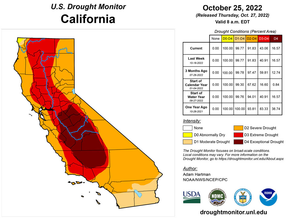
A strong storm system moved into the western U.S. heading into the weekend and moved across the Intermountain West leading up to Tuesday, October 25. Many locations across the Pacific Northwest, Great Basin, and the Rockies received in excess of 0.5 inches of rainfall, with the heaviest amounts (greater than 1 inch, with locally higher totals) concentrated across the Pacific Northwest, Idaho, and Montana. Precipitation was not enough to improve drought conditions in the Pacific Northwest, but was enough to halt another week of degradation along the windward slopes of the Cascades and Coastal Ranges. Only areas east of these ranges, in the rain shadows, experienced some targeted degradations. Farther south, D2 (severe) drought degraded to D3 (extreme drought) north of San Francisco, where USGS 28-day average stream flows have fallen below the 2nd percentile of the historical distribution, CPC soil moisture indicates D4-equivalent (exceptional drought) conditions, and the long-term objective drought blend depicts D3 conditions. Elsewhere, localized and targeted improvements were made across the Intermountain West, based on 7-day precipitation totals and improvements short-term precipitation deficits.
Caribbean
In Puerto Rico, USGS 7 to 14-day average stream flows have continued to decline again this week across the eastern tip of the island, with several stations falling below 10th percentile. NASA GRACE soil moisture also indicates below-normal soil moisture across this area. Therefore, D0 (abnormal dryness) was introduced to the eastern tip of the island.
In St. Thomas, the Cyril E King Airport had 0.65 inch of rain for the week and 1.66 inches (or 41.1% of normal) for the month-to-date. Year-to-date rainfall was at 89.5% of normal. Rainfall across the CoCoRaHS stations ranged between 0 to 0.95 inch. SPI values for the 1 month were indicative of severe drought, while drought free conditions were indicative at the 3, 6, and 9 months. SPI at the 12-month period is indicative of abnormally dry conditions. Groundwater levels at the Grade School 3 Well were steadily decreasing. St. Thomas drought classification was changed to short-term abnormally dry conditions.
The Henry Rohlsen airport in St. Croix received only 0.34 inch of rain this week, resulting in a month-to-date rainfall total of 1.77 inches or 48.1% of normal. Year-to-date total was 106.3% of normal. CoCoRaHS stations rainfall totals ranged between 0.04 to 0.70 inch for the week. SPI values at the 1 month were indicative of moderate drought, while the 3, 6, 9, and 12 months were indicative of drought free conditions. Despite some improvement on groundwater levels during September and early October, the levels are well below those seen in 2016. St. Croix's drought classification was changed to short and long-term abnormally dry conditions.
Drought free conditions persisted across St. John. The Windswept Beach had the most rainfall this week at 1.25 inches. The month-to-date total was 3.35 inches or 72.8% of normal. Year-to-date totals were 90.8% of normal. SPI values at the 1 and 12 months were indicative of abnormally dry conditions, while the 3, 6, and 9 months showed drought free conditions.
Pacific
Despite above-normal temperatures this week across Alaska, decent seasonal rainfall totals state-wide and time of year has swayed drought from developing. Therefore, Alaska remains drought-free this week.
In Hawaii, a cold front brought some enhanced rainfall to portions of the islands this week, with rain falling mainly on the north and northeast-facing slopes. Following the passage of the frontal boundary, returning trade winds were strong enough to bring rainfall to the windward slopes as well. Therefore, several 1-category improvements were warranted for interior Kauai and Oahu, northern Molokai, and eastern parts of the Big Island.
This was a wet week for most locations across the US Affiliated Pacific Islands, with rainfall totals surpassing their weekly threshold to meet most water needs. Pohnpei (6.33 inches), Fananu (8.48 inches), Yap (13.08 inches), and Pingelap (7.59 inches), in the Federated States of Micronesia (FSM), as well as Airai in Palau (7.26 inches) had the most notable precipitation amounts this week with rainfall totals surpassing 6 inches. These locations along with the Mariana Islands, Chuuk and Kosrae in the FSM, American Samoa, and most locations across the Marshall Islands continued to be free of drought.
In the Marshall Islands, Wotje was the only location to receive less than 1 inch of rain. This week marked the third consecutive week of little to no rain, resulting in a month-to-date rainfall total of only 3.10 inches. For this reason, Wotje's drought classification was changed to short-term abnormally dry conditions.
In the FSM, Kapingamarangi' continued to be in short and long-term severe drought since no rain fell this week. Lukunoch remained in short-term abnormally dry conditions since rainfall totals were less than 2 inches.
Looking Ahead
During the next five days (October 27-31), the storm system that brought heavy rainfall to parts of the Southern Plains will bring rainfall to parts of the eastern Great Lakes and Northeast before exiting the U.S. The pattern will remain active across the remainder of the CONUS. However, much of the precipitation potential will be across the Southern Plains, extending eastward across parts of the Deep South, associated with a low pressure system that is forecast to intensify over the Southern Plains by the weekend before moving eastward through the remainder of the week. The Pacific Northwest is also expected to remain active through Monday, October 31. Additionally, near to below-normal temperatures are expected across the West Coast and much of the Southern Tier of the CONUS, along the predicted storm track. Farther north from the Northern Plains to the Northeast, predominantly above-normal temperatures are forecast due to a lesser influence from the storm track farther south.
The Climate Prediction Center’s 6-10 day outlook (valid November 1-5) predicts increased chances of below-normal temperatures and above-normal precipitation across the western half and two-thirds of the CONUS, respectively, associated with mean mid-level low-pressure. Meanwhile, mid-level high pressure favors above-normal temperatures from the Great Plains to the East Coast and drier than normal conditions from the Mississippi Valley eastward. In Alaska, a southerly storm track favors predominantly above-normal precipitation and is forecast to keep temperatures cooler than normal.
Author(s):
Adam Hartman, NOAA/NWS/NCEP/CPC
Ahira Sanchez-Lugo, NOAA/NCEI
Dryness Categories
D0 Abnormally Dry—used for areas showing dryness but not yet in drought, or for areas recovering from drought.
Drought Intensity Categories
D1 Moderate Drought
D2 Severe Drought
D3 Extreme Drought
D4 Exceptional Drought
Drought or Dryness Types
S Short-term, typically less than 6 months (agriculture, grasslands)
L Long-term, typically more than 6 months (hydrology, ecology)
SL Area contains both short- and long-term impacts
Source: National Drought Mitigation Center
