


Oakhurst, Sunday Through Wednesday Projected Precipitation: 2.00" to 3.00" 3.00" to 4.00"
Yosemite Valley, Sunday Through Wednesday Projected Precipitation: 4.00" to 6.00"
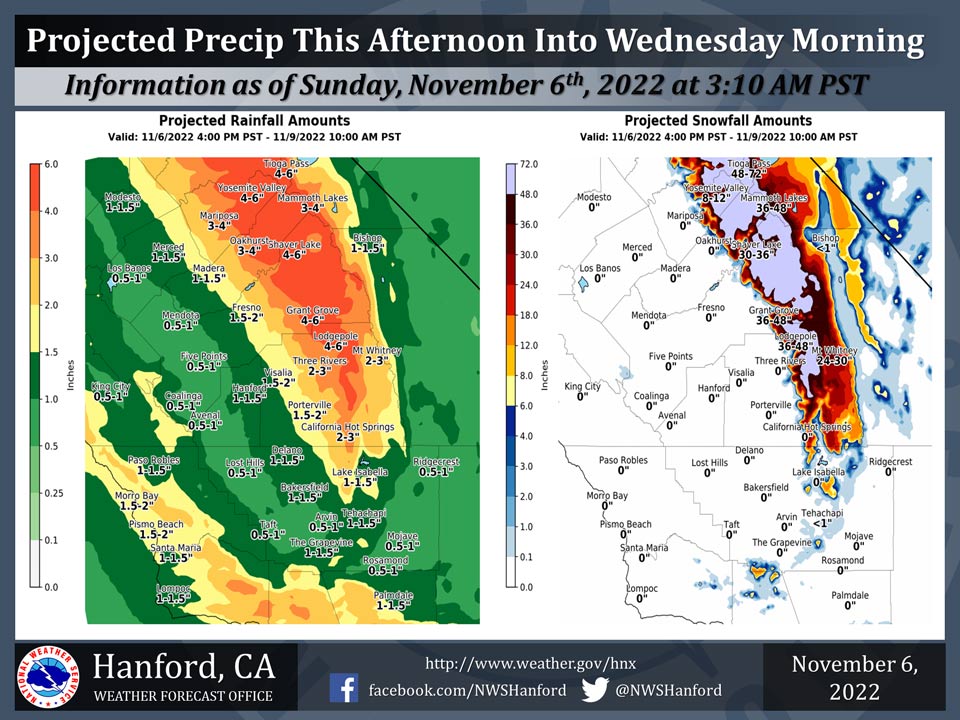
November 6, 2022 - The National Weather Service Hanford Office reports a major storm system will impact Central California late this weekend through early next week, resulting in significant precipitation.
Extreme winter storm impacts are expected in the Sierra Nevada.
A Winter Storm Warning is in effect for the Sierra Nevada. The majority of this precipitation will be confined to two periods, Sunday night into Monday morning and all day Tuesday.
Area Forecast Discussion
National Weather Service Hanford CA
229 AM PST Sun Nov 6 2022
.SYNOPSIS...Expect clouds and just some light rain spreading
across the area tonight ahead of a slow moving storm system. This
system will bring Widespread rain and mountain snow Sunday through
Wednesday morning along with increased winds and well below
normal temperatures. There is a slight chance for thunderstorms
Monday and Tuesday.
&&
.DISCUSSION...
Band of lower level cloud cover moving into the Central Valley
along a stronger westerly flow. Radar pick up some light shower
activity in Tuolumne county north of Yosemite. Otherwise clear
skies in the South Valley with milder temperatures across the
district. Satellite images show an a long fetch of moisture from
the Pacific moving into NCal. Precipitable water along the band
range from 150 to 200 percent above normal. WV images show a low
pressure system with cold unstable air located off the south
coast of British Columbia. Models prog the low moving south along
the coast interacting with the high PW moisture. This storm system
will bring the potential for widespread precipitation across CA
for a couple of days along with periods of heavy precipitation
across the mountains and locally heavy in thundershowers. 00z
Models in fair agreement with this system but have trended slower
with earlier ensemble forecast. This has extended the potential
for rain and low elevation another 12 hours perhaps through the
end of Wednesday.
Higher resolution models bring an initial disturbance into the
north sectors of the district towards the Yosemite area overnight
into Sunday morning. Precipitation amounts should not be heavy
with a couple of tenths possible over the Central sierra and a
high snow level around 8kft. A brief break in precipitation
potential this afternoon before more widespread precipitation
moves into the district tonight as the the upper trough moves off
the Pac NW coast. Stronger westerly flow will bring another surge
of moisture into central CA Sunday night and Monday. A strong
southwest flow over the sierra mountains will result in optimal
orographic upslope flow heavier precipitation potential on
Monday. The strong SW upper flow may continue through Tuesday and
continue to provide the orographic flow with heavy precipitation
possible across the sierra. The cold core low shifts inland
Tuesday night and south and east of the sierra Wednesday afternoon.
Isolated thundershowers can not be ruled out with strong dynamics
and weak instability over the district late Monday through
Wednesday.
Total accumulations around 4 feet are possible in the higher
elevations, with as much as 1-2 feet down around 4000 ft as snow
levels lower with the incoming storm system. By later Monday,
significant snow amounts begin to accumulate at the higher
elevations in Kern County, with as much as 7-14 inches on the
highest peaks. As snow levels drops to pass level Tuesday night
through Wednesday, we could see snow impacting travel over the
passes of Kern County. Currently there is a 5 to 10 percent
probability for at least 0.10 inch of snow at Fort Tejon and
Tehachapi Tuesday night Wednesday. With as much as 1-2 inches of
rain expected toward the est side of the San Joaquin Valley and
2-4 inches in the Sierra foothills, we will have to consider the
possibility of localized flooding in these areas.
As the storm system moves away, we will see ridging overhead for
mid to late week next week. Temperatures will remain well below
normal with frost possible in the Valley in the latter part of the
week, and possible fog concerns.
&&
.AVIATION...Clouds and light showers will spread southward across
central California overnight and through the day Sunday, creating
areas of MVFR conditions.
&&
.AIR QUALITY ISSUES...
ISSUED: 11/05/2022 14:49
EXPIRES: 11/06/2022 23:59
On Sunday November 6 2022...Fireplace/Wood Stove Burning Status
is: No Burning Unless Registered in Fresno and Kern Counties.
Burning Discouraged in Kings... Madera... Merced and Tulare
Counties... and Kern (Greater Frazier Park Area) and Sequoia
National Park and Forest.
Source: NWS
