


California and National Drought Summary for November 8, 2022
Summary
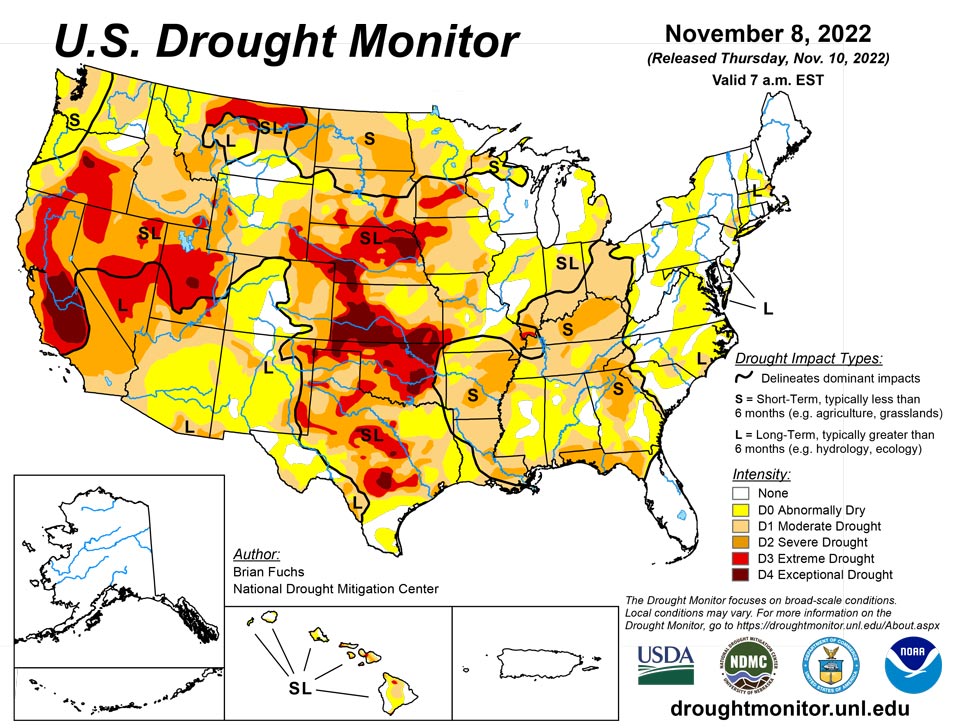
November 10, 2022 - This week continued with another active weather pattern over portions of the Pacific Northwest as well as into the central Plains and Midwest. With widespread heavy rain from Kansas into Wisconsin as well as portions of the lower Mississippi River valley, some areas recorded significant precipitation during the period. Temperatures over the eastern half of the country were above normal, some significantly, while most of the West was cooler than normal. A continued wet pattern over the Pacific Northwest as well as portions of the Midwest has allowed for continued improvement to drought intensities, especially in areas that are receiving abundant precipitation. Dryness continues to build over eastern portions of the Midwest and into the Southeast as well as along the Gulf Coast.
Northeast
Dry conditions dominated most of the region, with just a few pockets of rain taking place in the last week. Temperatures were well above normal for the region with most areas 12-15 degrees above normal. With the continued warm temperatures and dryness, abnormally dry conditions were expanded over central Pennsylvania, into Maryland and in portions of both northern and southern New Jersey, where moderate drought also expanded slightly in the north.
Southeast
Temperatures were well above normal, with most areas 9-12 degrees above normal for the week and pockets in the Carolinas that were 12-15 degrees above normal. Most of the region was dry, but some areas recorded well-above-normal precipitation. Most of Mississippi as well as western portions of Virginia, North Carolina and South Carolina and portions of central Florida all had above-normal precipitation, with areas of Mississippi over 200% of normal. Some improvements were made to moderate and severe drought as well as abnormally dry conditions where the greatest rains occurred. Degradation was widespread as dryness over the short term has started to impact the region. Severe drought was expanded over a large portion of central Georgia and into northern Florida. Moderate drought expanded over Georgia as well as portions of South Carolina and into southern North Carolina. Severe drought expanded over western North Carolina while more abnormally dry conditions were reflected over Alabama. It appears that a tropical storm system will be sweeping through the area that may potentially put an end to some of the recently observed dryness.
South
Temperatures over the region were well above normal, with departures of 6-9 degrees above normal during the week. Only areas of the panhandles of Texas and Oklahoma were near normal. The wettest areas of the region were in eastern Oklahoma, northeast and south Texas, Arkansas and Louisiana, where some areas recorded over 200% of normal rain this week. Much of central and west Texas and central Oklahoma missed out on any rains this week. A full category improvement to the drought intensities was made over much of Arkansas, western Louisiana, and eastern Texas. Severe drought was expanded over portions of southern Louisiana where much of the recent rain has missed. Drought intensities were expanded slightly in northeast Oklahoma and central portions of Texas due to a mixture of short- and long-term drought issues.
Midwest
A stark contrast in precipitation appears over the region where some areas were impacted by a strong frontal passage that brought with it excessive rain for this time of year. Those areas that missed out continued to be dry. From Wisconsin into Iowa and Missouri, the greatest rains occurred with over 200% of normal precipitation recorded during the week. Dry conditions dominated the Ohio River Valley as well as the Upper Midwest where the dryness has been mounting during autumn. Dryness allowed for degradation of drought intensities over Ohio, eastern Kentucky and central Indiana. Further degradation was observed over much of Minnesota again this week. Full category improvements to the drought intensities were made over western Kentucky, southern and northwest Missouri, central and eastern Iowa, and much of Wisconsin. Moderate drought was also reduced in northern Illinois with the recent rains. Extreme drought was eliminated from most of southeast Missouri as well as western Kentucky.
High Plains
Much of the High Plains remained dry this week with only portions of southeast Nebraska and eastern Kansas recording above-normal precipitation. Temperatures were mostly above normal for the area, but western portions were normal to slightly below this week, with the warmest temperatures over eastern Kansas where departures were 6-9 degrees above normal. With the continued dryness, most of the changes were worsening drought intensities. As the autumn remained dry over much of Nebraska, expansions were made to extreme and exceptional drought in the northeast and western parts of the state. Western Kansas, eastern Colorado and eastern Wyoming also had expansions of severe, extreme and exceptional drought conditions. Much of eastern and central Kansas saw improvement from several inches of rain, which lead to the reduction of all drought intensities (including the extreme and exceptional areas in the southern portion of the state) and the removal of extreme drought in the northeast.
West
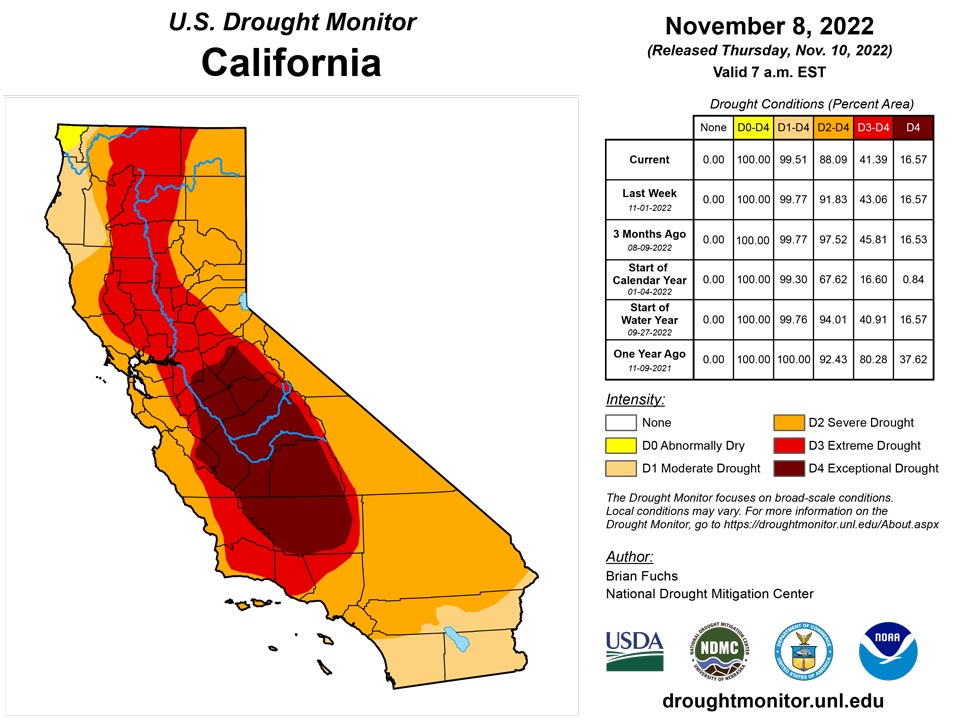
A wet week for much of the West helped to put a boost into the start of the current water year after a slow start. Continued wetness over the Pacific Northwest and into portions of the northern Rocky Mountains helped with long-term drought issues. Temperatures were cooler than normal for most of the region with some areas of Oregon and California 8-10 degrees below normal for the week. Improvements were made this week along the coastal regions of Oregon, Washington and northern California where moderate and severe drought were reduced. Areas of western Montana and northern Idaho also had drought intensities reduced with the recent wet pattern. Portions of western Wyoming saw expansion of moderate and severe drought while severe drought was improved in portions of western Colorado and northeast Utah.
Caribbean
There were no changes in Puerto Rico this week.
A tropical plume of moisture became re-established across the U.S. Virgin Islands in early November, maintaining showery, drought-free conditions. Both major airport observation sites received more than 4 inches of rain during the first 7 days of November. For both airport sites, daily-record rainfall totals occurred on November 5, with 3.24 inches drenching King Airport on St. Thomas and 3.40 inches soaking Rohlsen Airport on St. Croix. During the drought-monitoring period, more than a dozen volunteer (CoCoRaHS) observers spread across the three major islands noted rainfall ranging from 2.53 to 8.71 inches. The wet weather continued to improve soil moisture and groundwater reserves. Depth to water at the U.S. Geological Survey’s Grade School 3 well on St. Thomas decreased to less than 1.5 feet on November 7, a remarkable improvement from a depth greater than 18.5 feet as recently as August 13, 2022.
Pacific
There were no changes in Alaska this week.
Hawaii had another wet week that allowed for localized improvements. A full category improvement was made on Kauai and also on the east side of Oahu. On Molokai, the drought gradient continued to shift to the southwest in response to recent rains and improvements in the indicators. For Lanai, the middle of the island had a category improvement. On Kahoolawe, the east side of the island had improvements because of recent rains. Maui saw improvements to the windward side of the islands in the west and the south as well. For the Big Island, a portion of the Kohala Mountains in the north side of the island went from severe drought to extreme drought based on the indicators. Most of the rest of the Big Island had a 1-category improvement.
Generally quiet weather returned across the western Pacific Basin in early November, following active weather last month. Still, rainfall during the drought-monitoring period topped 2 inches in several locations, especially in American Samoa, the Republic of Palau, and the Federated States of Micronesia (FSM). However, some southern sites in the FSM remained dry, with severe drought (D2-SL) persisting for Kapingamarangi. Elsewhere in the FSM, Lukunor remained dry enough to support abnormal dryness (D0-S), while D0-S was introduced for Nukuoro. In the Republic of the Marshall Islands (RMI), Wotje retained a D0-S designation. Other places in the RMI have turned a bit drier, with Jaluit having received rainfall totaling just 0.15 inch in the last 2 weeks — following an above-normal sum of 12.59 inches in October. Drier weather at Majuro contributed to a 1.1 million gallon decrease in reservoir storage (from 26.5 to 25.4 million gallons) between November 3 and 6. Finally, the Mariana Islands remained free of dryness and drought, although showers have become more scattered in recent days. Guam International Airport received rainfall totaling 1.90 inches from November 1-8, while several volunteer (CoCoRaHS) observers elsewhere on the island recorded 1.05 to 3.22 inches of rain during the drought-monitoring period.
Looking Ahead
Over the next 5-7 days, it is anticipated that the impact of tropical storm Nicole over the east coast will be significant, bringing a great deal of precipitation from Florida to Maine during the next several days. A winter storm is impacting the northern Plains into the upper Midwest, bringing with it some significant snow while a frontal passage over the Plains will allow for some precipitation from Nebraska south into the lower Mississippi valley. Temperatures during this period look to be well below normal, with portions of the northern Plains 20-24 degrees below normal during this time. Warmer-than-normal temperatures will impact the Northeast and Mid-Atlantic, with temperatures 6-9 degrees above normal.
The 6–10 day outlooks show that temperatures are expected to be well below normal over most of the country, with areas of the Plains having the highest likelihood of recording below-normal temperatures. In contrast, Alaska is anticipating warmer-than-normal temperatures during this time. The greatest chance of above-normal precipitation is over the Southeast as well as through the Rocky Mountains while much of the central Plains and Midwest as well as the West have the greatest chances of having below-normal precipitation.
Author(s):
Brian Fuchs, National Drought Mitigation Center
Brad Rippey, U.S. Department of Agriculture
Dryness Categories
D0 Abnormally Dry—used for areas showing dryness but not yet in drought, or for areas recovering from drought.
Drought Intensity Categories
D1 Moderate Drought
D2 Severe Drought
D3 Extreme Drought
D4 Exceptional Drought
Drought or Dryness Types
S Short-term, typically less than 6 months (agriculture, grasslands)
L Long-term, typically more than 6 months (hydrology, ecology)
SL Area contains both short- and long-term impacts
Source: National Drought Mitigation Center
