


California and National Drought Summary for November 15, 2022
Summary
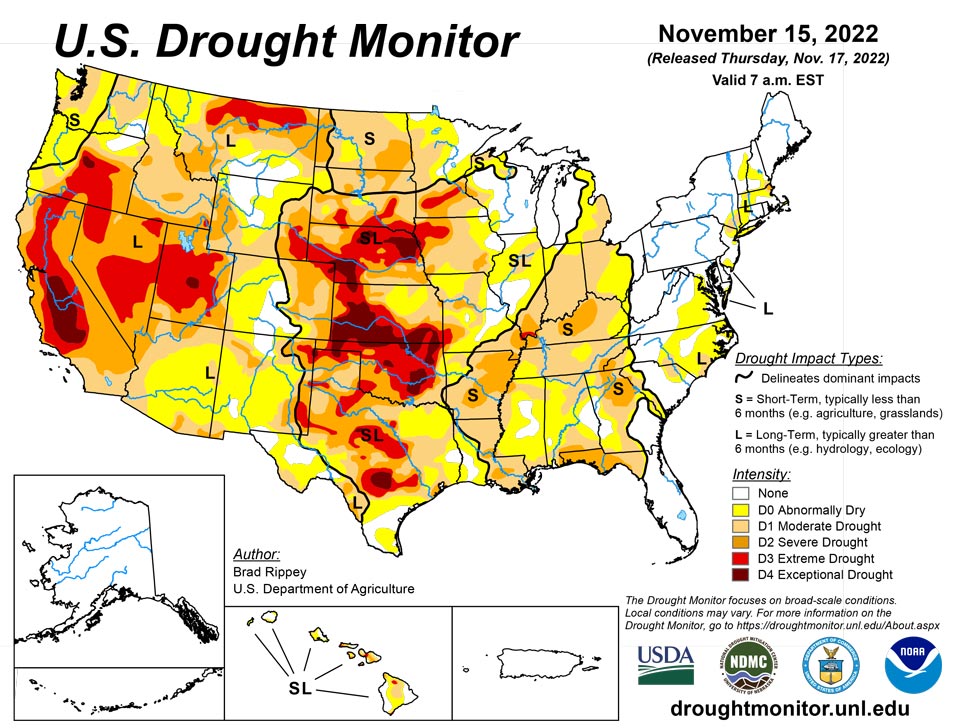
November 17, 2022 - In some areas of the country, storminess chipped away and dryness and drought. Notably, on the 10th, Nicole became the first November hurricane to make landfall on the U.S. mainland since 1985, when Kate struck near Mexico Beach, Florida, on November 21. Nicole, a Category 1 hurricane with sustained winds near 75 mph, moved ashore just south of Vero Beach, Florida, around 3 am EST. Nicole’s remnants eventually affected the entire eastern U.S., providing varying degrees of relief from autumn dryness. Some of the heaviest rain, locally 4 inches or more, fell in the central and southern Appalachians and neighboring areas. The rain helped to boost streamflow in the upper reaches of the Ohio River basin, with runoff moving downstream as the drought-monitoring period ended. Farther west, a storm system produced heavy snow and local blizzard conditions in the north-central U.S., while parts of the West received drought-easing precipitation. However, many other areas of the country remained mostly dry. Frigid conditions developed in conjunction with the Western storminess and expanded eastward, while much of the lingering warmth in the South and East was swept away, shortly after Nicole’s departure.
Northeast
On November 11-12, the remnants of Hurricane Nicole delivered significant rain, especially across interior sections of Maryland, West Virginia, Pennsylvania, and New York. On the 11th, daily-record rainfall totals topped the 2-inch mark in locations such as Pittsburgh, Pennsylvania (2.36 inches), and Wheeling, West Virginia (2.30 inches). Abnormal dryness (D0) was broadly eradicated where the heaviest rain fell. Closer to the coast, however, showers were mostly light and scattered, leading to only minor reductions in the coverage of abnormal dryness (D0) and moderate to severe drought (D1 to D2).
Southeast
In advance of Nicole’s arrival, tropical showers began to overspread Florida by November 8, when daily-record totals included 1.23 inches in Sanford and 1.01 inches in Orlando. Sanford received another daily-record sum (1.95 inches) on the 9th, helping to boost its November 8-10 total to 5.32 inches. On the 10th, the day Hurricane Nicole moved ashore in Florida, daily-record totals reached 2.64 inches in Jacksonville and 2.51 inches in Gainesville. Closer to the point of landfall, peak gusts on the 10th reached 72 mph in Melbourne and 70 mph in Daytona Beach. As rain spread northward on the 11th, daily-record amounts topped 2 inches in many locations, including Roanoke, Virginia (2.88 inches), and Asheville, North Carolina (2.26 inches). Drought-affected areas receiving the heaviest rain experienced improvements of up to one category. On November 13, following Nicole’s departure, the U.S. Department of Agriculture rated topsoil moisture 57% very short to short in Alabama, a three percentage-point improvement from the previous week. During the same one-week period, topsoil moisture rated very short to short improved from 68 to 48% in South Carolina and from 76 to 44% in Georgia.
South
Late in the drought-monitoring period, precipitation developed across eastern sections of Oklahoma and Texas before spreading into the lower Mississippi Valley. Targeted reductions in drought coverage up to one category were made where the heaviest rain fell. However, much of the region received little or no precipitation. By November 13, the U.S. Department of Agriculture rated topsoil moisture at least one-half very short to short in Oklahoma (76%), Texas (71%), and Louisiana (58%). On the same date, the recently planted winter wheat crop continued to struggle in the driest areas, with 48% of the crop rated in very poor to poor condition in Texas, along with 42% in Oklahoma. In Arkansas, only 59% of the winter wheat had emerged by November 13, compared to the 5-year average of 66%. Rangeland and pastures continued to reflect the effects of drought, with 82% rated in very poor to poor condition in Oklahoma, along with 62% in Arkansas, and 57% in Texas.
Midwest
Heavy precipitation in the upper Great Lakes region provided drought relief, but many other areas of the Midwest experienced dry weather. Eastern Michigan was one area that had a notable increase in the coverage of abnormal dryness (D0) and moderate drought (D1). In contrast, heavy rain associated with the remnants of Hurricane Nicole fell in eastern sections of Ohio and Kentucky. Zanesville, Ohio, received a daily-record rainfall total of 2.20 inches on November 11. A day earlier in Minnesota, a winter-like storm system had delivered daily-record precipitation totals to Minnesota locations such as Hibbing (1.35 inches) and Brainerd (1.27 inches). Even with nearly an inch of rain falling in Minneapolis-St. Paul, Minnesota, from November 8-10, the Twin Cities’ year-to-date precipitation remained more than 9 inches below normal. Meanwhile, the Ohio River experienced a beneficial rise from runoff related to Nicole. Along the Kentucky-Indiana border, the Ohio River at the Markland Lower gauge site rose nearly 12 feet between November 12 and 15. Farther downstream, in southern Illinois, the Ohio River climbed above low-water stages of 15.0 feet in Shawneetown and 9.4 feet in Cairo. Just last month, the preliminary minimum stage at Cairo, 4.88 feet on October 17, represented the lowest river level in that location since 1901. Cairo’s stage climbed to 15 feet (and rising) by November 15. Late in the drought-monitoring period, light to moderately heavy snow overspread much of the Midwest. Minneapolis-St. Paul measured a daily-record snowfall (2.5 inches) on November 14. The following day, record-setting snowfall totals for the 15th included 3.5 inches in Waterloo, Iowa, and 2.8 inches in Madison, Wisconsin.
High Plains
An early-season winter storm produced significant, wind-driven snow and freezing rain across parts of the Dakotas. Officially, 17.0 inches of snow—with a liquid equivalency of 1.23 inches—blanketed Bismarck, North Dakota, on November 10, accompanied by wind gusts as high as 37 mph. Elsewhere in North Dakota, wind gusts at the height of the storm reached or exceeded 40 mph in Garrison, Jamestown, and Minot. Bitterly cold weather trailed the storm. The northern Plains’ moisture, while highly beneficial for winter wheat, had a limited immediate effect on the drought situation, leading to only small improvements in the depiction. Farther south, drought continued to gradually worsen in other parts of the region. On November 13, the U.S. Department of Agriculture reported topsoil moisture rated very short to short ranging from 65% in North Dakota to 87% in South Dakota. On the same date, winter wheat across the region remained in dismal condition, with more than one-third of the crop rated very poor to poor in Colorado (45%), Kansas (40%), Nebraska (38%), and South Dakota (37%).
West
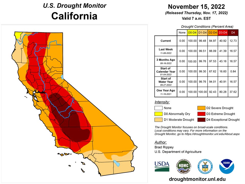
Over the past couple of weeks, beneficial precipitation has helped to establish high-elevation snowpack and has provided limited relief from long-term drought. The improved moisture has also benefited winter grains and cover crops. The latest round of significant rain and snow overspread much of the region early in the drought-monitoring period and lasted for several days. On November 7, the last full day of the previous period, Spokane, Washington, measured a daily-record snowfall of 3.8 inches. Also on the 7th, Elko, Nevada, set daily records for precipitation (0.76 inch) and snowfall (7.5 inches). Elko’s November 7-9 snowfall reached 13.1 inches. Similarly, Alta, UT, noted a 3-day (ending November 10) storm total of 27.7 inches. On November 8, daily-record amounts in southern California included 1.44 inches at Los Angeles International Airport and 1.13 inches in Burbank. Elsewhere in southern California, 48-hour totals on November 7-9 reached 6.84 inches on Palomar Mountain, 6.76 inches at Big Bear Lake, and 4.80 inches in Idyllwild. In Utah, 24-hour precipitation totals on November 8-9 topped an inch in Randolph (1.20 inches), Logan (1.09 inches), and Zion National Park (1.05 inches). Daily-record snowfall on the 9th totaled 3.1 inches in Pocatello, ID, and 3.0 inches in Kanab, UT. During the extended period of unsettled weather, Pocatello noted 8.8 inches of snow from November 7-10. Later, cold, dry weather replaced previously stormy conditions throughout the West. Sub-zero temperatures were common across the northern Rockies and northern Intermountain West, with Greybull, Wyoming, reporting five consecutive readings below 0°F from November 10-14, along with a daily-record low of -14°F on the 11th. In Glasgow, Montana, a daily-record low of -15°F on November 10 was preceded and accompanied by 11.5 inches of snow, starting on the 8th. Other sub-zero, daily-record lows in Montana included -15°F (on the 8th) in Great Falls and -17°F (on the 11th) in Miles City.
Caribbean
Puerto Rico received spotty showers, heaviest in eastern areas, and remained completely free of dryness and drought for a third consecutive week.
There is no drought or abnormal dryness in the U.S. Virgin Islands. Some locations were wet while others had less rain this week. Localized heavy showers gave parts of St. Croix over an inch of rain, with Rohlsen Airport reporting 1.63 inches of rain for the week and a couple CoCoRaHS stations turning in about an inch and a third. Weekly rainfall totals from other St. Croix stations ranged from 0.13 to 0.73 inch. On St. John, weekly rainfall totals ranged from 0.30 inch to 1.03 inches, while on St. Thomas the values ranged from 0.22 to 0.73 inch. Previous weeks have been wet across the islands. Monthly rainfall totals through November 14 at the primary stations included 5.35 inches at King Airport on St. Thomas, 5.95 inches at Rohlsen Airport, and 6.61 inches at Windswept Beach on St. John. These were all well above normal.
The Standardized Precipitation Index (SPI) indicated normal to wet conditions at all time scales from the last 1 month to last 12 months. Satellite observations showed few areas of stressed vegetation, with the Vegetation Health Index (VHI) reflecting improving conditions. According to the USGS well statistics, groundwater has fully recovered on St. Thomas. The groundwater level on St. Croix continues to rise, but it is still below historical levels.
Pacific
Alaska continued to experience robust storminess and remained free of dryness and drought.
In the wake of drought-easing rainfall, Hawaii turned somewhat drier amid a predominantly trade-wind regime. As a result, no further improvement was noted in Hawaii, following 9 consecutive weeks with a reduction in drought coverage. On the Big Island, Hilo received rainfall totaling 9.44 inches during the first 5 days of November—but netted just 1.62 inches from November 6-15.
Typical tropical weather systems brought rain to parts of the U.S.-Affiliated Pacific Islands (USAPI) this week. A monsoon trough spread rain across Palau and large parts of the Federated States of Micronesia (FSM). Nukuoro was drenched with 4.77 inches of rain for the week, which ended abnormal dryness there. The wet region was just north of Kapingamarangi, which received just 0.64 inch of rain for the week, with severe drought (D2-SL) continuing. Abnormal dryness (D0-S) continued at Lukunor and began at Fananu, where weekly rainfall totals were only 0.15 inch and 0 inches, respectively, and month-to-date totals were just 0.25 and 1.01 inches, respectively. But these two stations were missing several days of data for this week. The rest of the stations in the FSM and Republic of Palau had no drought or abnormal dryness.
The Marianas and American Samoa were wet this week, with weekly rainfall totals above the 1-inch minimum needed to meet most water needs. Previous weeks were wet, so no drought or abnormal dryness exists in these regions.
A narrow Inter-Tropical Convergence Zone (ITCZ) developed across southern parts of the Marshall Islands, giving most islands 2 inches or more of rain this week. Northern islands received less, with Kwajalein reporting only an inch and Wotje reporting no rain this week. Most of the Marshall Islands had no drought or abnormal dryness, except northern areas where Wotje continued abnormally dry (D0-S).
Looking Ahead
Cold weather will continue to dominate much of the country through the weekend and into early next week. At the height of the cold wave, temperatures could fall to 20°F or below as far south as the Tennessee Valley, while freezes may reach nearly to the Gulf Coast in Louisiana, Mississippi, Alabama, and northern Florida. Meanwhile, continental U.S. storminess during the next 5 days will be minimal. However, snow squalls will continue for several days downwind of the Great Lakes. In addition, rain may develop in the western Gulf Coast region. Elsewhere, aside from snow showers in the Rockies and adjacent High Plains, dry weather will prevail during the next 5 days from the Pacific Coast eastward across the central and southern Plains, the middle and lower Mississippi Valley, and much of the Southeast.
The NWS 6- to 10-day outlook for November 22 – 26 calls for the likelihood of near- or above-normal temperatures nationwide, except for lingering cooler-than-normal conditions in the middle and northern Atlantic States and parts of the south-central U.S. Meanwhile, near- or below-normal precipitation from California to the Plains, Midwest, and mid-South should contrast with wetter-than-normal weather in the Northwest and large sections of the Gulf and Atlantic Coast States.
Author(s):
Brad Rippey, U.S. Department of Agriculture
Richard Heim, NOAA/NCEI
Dryness Categories
D0 Abnormally Dry—used for areas showing dryness but not yet in drought, or for areas recovering from drought.
Drought Intensity Categories
D1 Moderate Drought
D2 Severe Drought
D3 Extreme Drought
D4 Exceptional Drought
Drought or Dryness Types
S Short-term, typically less than 6 months (agriculture, grasslands)
L Long-term, typically more than 6 months (hydrology, ecology)
SL Area contains both short- and long-term impacts
Source: National Drought Mitigation Center
