


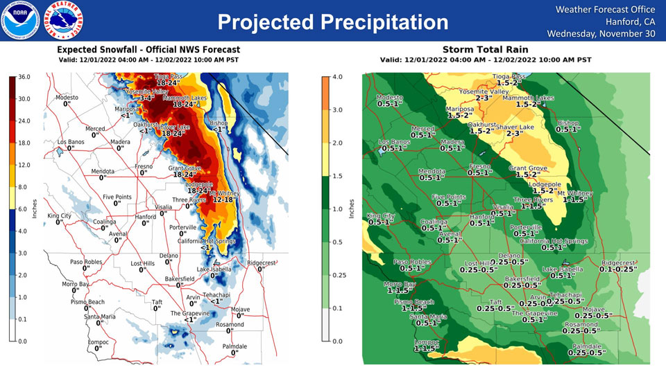
Mariposa, Thursday Projected Precipitation: 1.50" to 2.00"
Oakhurst, Thursday Projected Precipitation: 1.50" to 2.00"
Yosemite Valley, Thursday Projected Precipitation: 2.00" to 3.00"
November 30, 2022 - The National Weather Service Hanford Office reports the next storm system will impact Central California Thursday through Friday morning.The majority of precipitation associated with this storm system will fall Thursday afternoon and Thursday evening.
Snow levels will start at around 5,000 feet Thursday, before dropping to about 4,000 feet Thursday night.
A Winter Storm Warning is in effect for the Sierra Nevada.
Area Forecast Discussion
National Weather Service Hanford CA
400 AM PST Wed Nov 30 2022
.SYNOPSIS...Dry and mild conditions will continue today, ahead of
a winter storm which will arrive on Thursday morning and will
bring widespread rain and mountain snow through Friday morning.
Cooler temperatures and unsettled weather will then prevail over
the weekend with more rain and mountain snow possible.
&&
.DISCUSSION...
A dry northwesterly flow prevails over central California, and
clear skies and light winds are providing for good overnight
cooling. Minimum temperatures are on track to dip to around the
freezing mark during the early morning hours at many San Joaquin
Valley locations, and a Freeze Warning remains in effect there
through 8 AM. Temperatures will recover well under sunny skies
today, and another mild day is on tap.
A change is in store beginning Thursday, as ensemble model
solutions prog a significant northeast Pacific storm system to
dip southward, bringing cooler temperatures along with rain and
mountain snow to our area. The storm will steer a moisture fetch
across central California from Thursday morning into early Friday
morning as it swings eastward. During this period QPF guidance
shows around 1/3 of an inch of rainfall in the south Valley, with
1/2 to 3/4 of an inch farther north and up to 1-2 inches in the
foothills up to the snow level which will drop as low as around
3000 ft early Friday morning. Desert areas are forecast to receive
as much as 1/4 to 1/3 of an inch. Impactful snow will accumulate
in the higher elevations, with much of the area above 5000 ft
north of Sequoia National Park receiving between one and three
feet of new snow. Blended model guidance probabilities are around
25 to 35 percent for at least 24 inches of snow in these
locations. A Winter Storm WArning is in effect for the Sierra from
Sequoia National Park northward to Yosemite from 4 AM Thursday to
10 AM Friday. The storm will also bring as much as 8 to 16 inches
further southward, and a Winter Weather Advisory is in effect for
the south end of the Sierra from 10 AM Thursday through 10 AM
Friday.
Some snow could reach the major highway passes in Kern County
early Friday morning as snow levels fall, with probabilities as
high as 40 to 50 percent for at least 1/10 of an inch of snow
there. Probabilities for 1 inch of snow however are less than 10
percent.
Another system with less available moisture will bring additional
precipitation Saturday night through Sunday night. Rainfall
amounts around 1/10 to 1/3 of an inch are forecast for the San
Joaquin Valley, and around 6-12 inches of snow at the higher
Sierra elevations. Cooler temperatures are also on tap with the
passing storm systems, and temperatures will generally run around
4-8 degrees below normal through the weekend and into next week.
By the middle of next week, probabilities of overnight lows below
32 degrees in much of the San Joaquin Valley are as high as 70 to
90 percent.
&&
.AVIATION...Areas of MVFR visibility in mist in the San Joaquin
Valley between 12Z Wed and 18Z Wed. Otherwise, VFR conditions
will prevail across the central CA interior for at least the next
24 hours.
&&
.AIR QUALITY ISSUES...
On Wednesday November 30 2022,Fireplace/Wood Stove Burning Status
is: No Burning Unless Registered in Fresno, Kern, Kings, Madera,
and Tulare Counties. Burning Discouraged in Merced County, and
Kern (Greater Frazier Park Area) and Sequoia National Park and
Forest.
Source: NWS
