


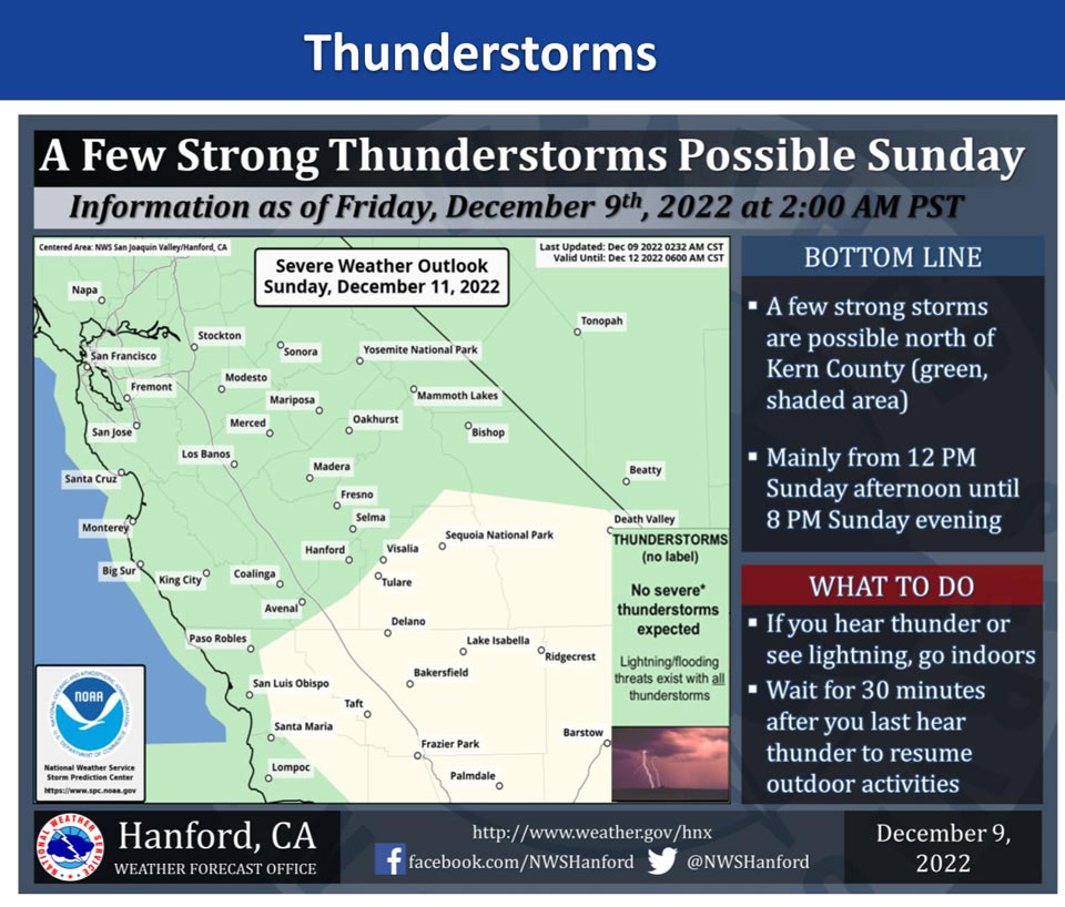
December 9, 2022 - The National Weather Service Hanford Office reports a few strong thunderstorms are possible north of Kern County Sunday.
Small hail and wind gusts near 45 miles per hour are a couple of hazards associated with strong thunderstorms.
In addition to dangerous cloud to ground lightning strikes, any thunderstorm can produce intense rainfall rates, leading to localized flooding.
Area Forecast Discussion
National Weather Service Hanford CA
201 AM PST Fri Dec 9 2022
.SYNOPSIS...
A weak weather system will brush our area this morning, bringing
a few showers, mainly north of Fresno County. A stronger system
will bring rain and mountain snow to Central California early
Saturday morning through the weekend. Freezing temperatures are
likely in the San Joaquin Valley for much of next week. Another
storm system is forecast for late next week and into the weekend.
&&
.DISCUSSION...
A weak cold front is moving across the region overnight tonight. A
few showers...mainly north of Fresno county are being detected on
the radar attm. The front is expected to weaken as well as the
showers.
Today we will see a mix of clouds and sun today as we prepare for
a potent cold storm system dropping out of the Gulf of Alaska and
arriving Saturday. The models have been trending slower with the
system and even todays deterministic 06z run of the NAM12 isn't
bringing the precip into the CWA by the 15z-18z timeframe. We will
tighten up the timing as we get closer to the event.
National Blended Model is predicting at least nearly an half an
inch to an inch of rain across most of the SJV from Saturday
morning through Monday morning. This is a cold system and does not
have an Atmospheric River connection with it like the last storm.
However, this system has a lot of energy with it and will wring
out every ounce of moisture that is available to it. Foothills
will once again see another round of heavy rain below the snow
line, which if forecast to start around 4500 feet on Saturday and
lower to around 2500 feet on Monday. I am a little concerned that
the QPF might be a little too high, since there is no AR attached
to it. We will continue to monitor for any trending downward as we
get closer to the event. We are forecasting from one to three
inches of rain in the foothills below the snow line. We are
also forecasting 3 to 4 feet with isolated amounts of up to 5
feet above 4500 feet.
There is a lot of cold air with this system and once the system
moves out of the region by Monday night we will see subfreezing
temperatures across the SJV on Wednesday and Thursday mornings. We
are encouraging people to protect their pets, plants and pipes
during this cold spell next week.
Another weather system if forecast to drop out of the Gulf of
Alaska on Thursday and bring a warm front in here with maybe a
few showers. The storm system is forecast to link up with an AR
event and bring subtropical moisture into the region Friday
evening and continue with more wet weather through the weekend.
&&
.AVIATION...Areas of IFR/LIFR conditions will develop north of
Kern County in showers as well as San Joaquin Valley haze and
mist between 06Z and 12Z Friday. Otherwise, VFR conditions
expected across central California for the next 24 hours.
&&
.AIR QUALITY ISSUES...
ISSUED: 12/08/2022 14:57
EXPIRES: 12/09/2022 23:59
On Friday December 9 2022,Fireplace/Wood Stove Burning Status is:
No Burning Unless Registered in Fresno, Kern, Kings, Madera,
Merced, and Tulare Counties. Burning Discouraged in Kern (Greater
Frazier Park Area) and Sequoia National Park and Forest.
Source: NWS
