


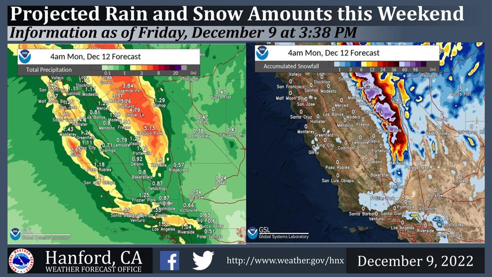
Mariposa: 3.31" inches of rain.
Oakhurst: 3.76" inches of rain.
Yosemite Valley: 3.84" inches of rain.
December 9, 2022 - The National Weather Service Hanford Office reports a strong storm system will impact Central California this weekend.
The majority of precipitation associated with this storm system will fall Saturday night and Sunday.
Snow levels will start at around 4,000 feet Saturday, before rising to about 6,000 feet Saturday evening into Sunday morning. Snow levels will drop to around 3,000 feet by Sunday evening.
Area Forecast Discussion
National Weather Service Hanford CA
248 PM PST Fri Dec 9 2022
.SYNOPSIS...
A stronger system will bring rain and mountain snow to Central
California early Saturday morning through the weekend. Freezing
temperatures are likely in the San Joaquin Valley for much of next
week. Another storm system is forecast for late next week and
into the following weekend.
&&
.DISCUSSION...We are between systems at this time, although cloud
cover is beginning to increase from the the north ahead of our
approaching winter storm. In other words, enjoy the calm before
the storm while it lasts. The main concerns will be the heavy
precipitation, including heavy rain in the Sierra foothills and
very heavy snow over the Sierra Nevada over the weekend. Snow will
begin falling by Saturday morning in the Sierra, though onset
timing will be later further south, or by late Saturday afternoon
towards Kern County. Ahead of the precipitation, some gusty
southerly winds will develop by Saturday afternoon and evening.
Gusts to 55 mph are expected in the Coastal Ranges along the west
side of the San Joaquin Valley and the Frazier Mountain/Grapevine
areas, with some locally stronger gusts over the highest peaks.
Very heavy snowfall rates, or around two to three inches per hour,
are anticipated with this storm over the highest elevations, or
mainly above 6,000 feet, including from Saturday afternoon and
through the overnight hours on Saturday night. In addition,
whiteout conditions will occur in these highest elevations due to
gusty winds and poor visibility at times. Snow accumulation from
Saturday until Sunday night overall has a good chance of reaching
at least two feet (50 to 60 percent probability) and 25 to 40
percent for amounts of four feet and higher. The bulk of the
precipitation will occur on Saturday afternoon into the overnight
hours of early Sunday morning. This contributes to extreme values
(or at least the major category) of the Winter Storm Severity
Index, issued by the Weather Prediction Center (wpc.ncep.noaa.gov)
for much of the Sierra Nevada. By Saturday evening, the snow
level will rise to above 6,000 feet after an initial level of
around 3,500 feet on Saturday morning.
By Sunday, expect precipitation amounts and hourly rates to
overall decrease. However, there is a slight chance of brief
heavy precipitation accompanied with hail due to thunderstorms by
the afternoon. The snow level will lower down to around 3,000
feet on late Sunday afternoon into the evening, although mainly
light accumulations are expected by this time across much of the
region. As for the mountain passes in Kern County, including
Sunday night into Monday morning, there is about a 25 percent
chance of snow accumulations near 0.5 inch towards the Grapevine
and about a 40 percent chance of one inch of snow at Tehachapi.
Starting Monday night, much colder temperatures will occur
throughout the region, including freezing overnight lows in the
San Joaquin Valley and lows in the mid to upper 20's in the Kern
County desert. Similar temperatures will continue each night and
morning until Thursday morning.
The next opportunity for precipitation chances occurs by Thursday
evening into next Friday. As of now, amounts are much lighter than
this weekend's system. Temperatures are projected to be
seasonably cool.
&&
.AVIATION...MVFR conditions expected after 15Z Saturday due to
showers at MCE and MER, spreading southward to FAT & VIS after
18Z Saturday, and to BFL by 00Z Sunday. Gusty winds with gusts
around 35-45 kts expected over the Coastal Ranges along the west
side of the San Joaquin Valley after 18Z Saturday. Also expect
IFR conditions due to rain, snow, and mountain obscurations over
the Sierra Nevada after 12Z Saturday. Otherwise, VFR conditions
expected across central California for the next 24 hours.
&&
.AIR QUALITY ISSUES...
On Friday December 9 2022,Fireplace/Wood Stove Burning Status is:
No Burning Unless Registered in Fresno, Kern, Kings, Madera,
Merced, and Tulare Counties. Burning Discouraged in Kern (Greater
Frazier Park Area) and Sequoia National Park and Forest.
Source: NWS
