


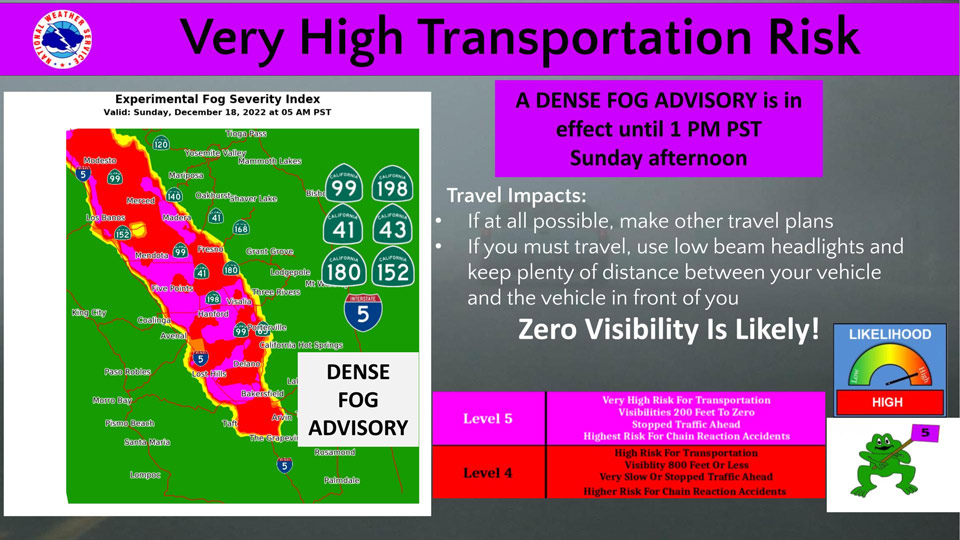
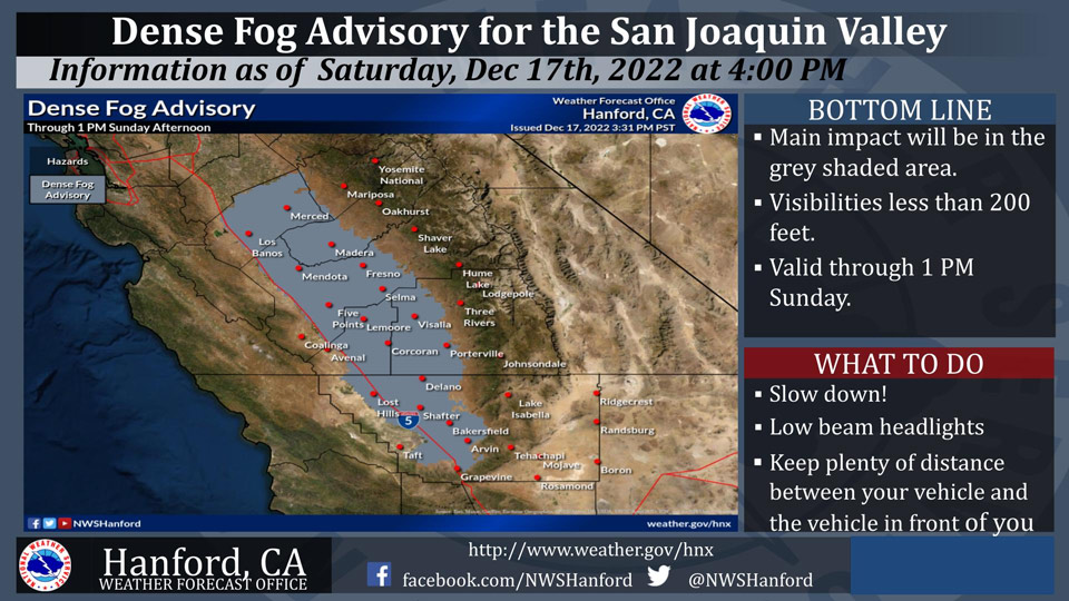
December 18, 2022 - The National Weather Service Hanford Office reports a Dense Fog Advisory is in effect for the San Joaquin Valley until 1:00 P.M. Sunday, resulting in a very high transportation risk.
Highways affected include, but are not limited to Highway 99, Highway 198, Highway 41, Highway 43, Highway 180 and Highway 152.
Area Forecast Discussion
National Weather Service Hanford CA
118 AM PST Sun Dec 18 2022
.SYNOPSIS...
Dense fog in the mornings along with freezing temperatures will
continue until Monday. Expect temperatures to slowly climb Tuesday
through the rest of the week, although valley fog will remain
possible in the nights and mornings. Expect a warming trend this
week, with daytime highs rising to around five to ten degrees
above average by the holiday weekend.
&&
.DISCUSSION...Latest satellite data show high clouds over southern
portions of NWS Hanford's CWA while observation data show fog and
low ceilings persisting over the Central Valley. Some locations
have reported improved visibility and drizzle, including around
Hanford and areas to the south which remained cloudy and foggy for
much of yesterday. Other locations that briefly cleared yesterday
afternoon, including Fresno to Merced, are currently reporting
dense fog. Fog and stratus will likely continue over much of the
San Joaquin Valley into this afternoon, so will keep the Dense Fog
Advisory in effect.
There is about a 85 to 90 percent chance that daily minimum
temperatures will lower to freezing in the outlying areas of the
San Joaquin Valley until Monday morning. Due to persistent cloud
cover in some areas, it appears there is a lesser chance of
minimum temperatures lowering back to freezing or a little colder
for the remainder of tonight into the daylight hours of this
morning. It is also uncertain where cloud cover will clear out
once again today. Nevertheless, we will keep the Freeze Warning
in effect into Monday, as there are quite a few areas that cleared
out earlier. On Monday night into Tuesday morning, high
resolution guidance shows a weak shortwave trough that will bring
at least some increased cloud cover and a slight chance to squeeze
out some light precipitation over the Sierra Nevada. Otherwise, we
don't anticipate any significant rain and mountain snow over the
next seven days.
A gradual warming trend will commence by Tuesday with less
widespread freezing temepratures in store as high pressure
restrengthens over the Golden State and offshore. Latest ensemble
and deterministic guidance continue in good agreement in
depicting this overall pattern. Thus, we anticipate milder
temperatures by late this week into the upcoming holiday weekend.
Daytime highs have a 50 to 65 percent probability of reaching the
lower 60's, or around five to ten degrees above normal, in the
Central Valley by Christmas Day. However, valley fog development
is typical during episodes of upper-level ridges of high pressure
during this time of year, so there remains a bit of uncertainty.
&&
.AVIATION...
IFR conditions with areas of LIFR across the San Joaquin Valley
will continue until 21Z Sunday due to persistent fog. Otherwise,
VFR conditions will prevail throughout the Central California
interior for the next 24 hours.
&&
.AIR QUALITY ISSUES...
On Sunday December 18 2022, Unhealthy in Kern County. Unhealthy
for Sensitive Groups in Fresno, Kings, and Tulare Counties.
Fireplace/Wood Stove Burning Status is: No Burning For All in
Fresno and Kern Counties. No Burning Unless Registered in Kings,
Madera, Merced, and Tulare Counties. Burning Discouraged in Kern
(Greater Frazier Park Area) and Sequoia National Park and Forest.
&&
.CERTAINTY...
The level of certainty for days 1 and 2 is high.
The level of certainty for days 3 through 7 is medium.
Certainty levels include low...medium...and high. Please visit
www.weather.gov/hnx/certainty.html for additional information
and/or to provide feedback.
&&
.HNX WATCHES/WARNINGS/ADVISORIES...
Dense Fog Advisory until 1 PM PST this afternoon for CAZ301>303-
305>307-309>312-314>316.
Freeze Warning until 7 AM PST Monday for CAZ301>303-305-306-
309>312-315.
Source: NWS
