


California and National Drought Summary for December 27, 2022
Summary
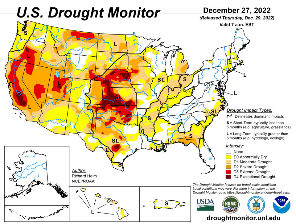
December 29, 2022 - A powerful low-pressure trough developed in the upper levels of the atmosphere over the eastern contiguous U.S. (CONUS) during this U.S. Drought Monitor (USDM) week (December 21-27). At the surface, the trough was associated with a strong cold front that poured frigid arctic air into the U.S. east of the Rockies. Daytime maximum temperatures in the northern Plains were well below zero degrees Fahrenheit, with minimum temperatures colder than 20 below zero, at the peak of the cold wave. Bismarck, North Dakota, registered minus 10 for a high and minus 20 for a low on December 21 and 22; the high was below zero for 4 consecutive days and below freezing for at least 2 consecutive weeks. Williston, North Dakota, recorded minus 17 for a high and minus 29 for a low on December 20. The freezing arctic air spread to the Gulf of Mexico and East coasts, and even breeched the Rocky Mountain chain to reach the Pacific Northwest. The high temperature at Tupelo, Mississippi, was only 18 degrees with a low of 4 on December 23. Rain, freezing rain, and snow accompanied the arctic front as it swept east and south. An inch or more of precipitation fell across parts of the Gulf Coast and from the Appalachians to East Coast when the front tapped Gulf and Atlantic moisture. Some parts of the Mid-Atlantic and Northeast states received over 2 inches of precipitation, while an inch or more occurred over the lee sides of the Great Lakes, largely in the form of heavy lake effect snow. Buffalo, New York, officially measured 50.3 inches of snow from December 23-26, but much more snow fell in other favored leeside areas. Locally up to half an inch of precipitation occurred from the northern Plains to Upper Mississippi Valley. But the northwesterly flow was otherwise dry, so large parts of the Great Plains, Mississippi Valley, and Ohio Valley to Gulf Coast received less than half an inch of precipitation to no precipitation. The arctic blast froze soils across much of the Great Plains to Upper Mississippi Valley. Any precipitation that fell was not able to penetrate the frozen ground to increase soil moisture, so much of this region had no change in USDM status. In reaction to the eastern trough, an upper-level ridge developed over the western CONUS. This kept weekly temperatures near to warmer than normal from California to the Four Corners states, but it also kept much of the West dry. The exception was northern California to the Pacific Northwest and parts of the central and northern Rockies, where Pacific fronts brought areas of rain and snow. Two inches or more of precipitation fell in coastal areas and in the northern Rockies, with up to ten inches in parts of western Washington. Meanwhile Hawaii and Puerto Rico had a mostly drier-than-normal week while drier- and colder-than-normal weather dominated Alaska. The deep freeze and dry weather resulted in status quo conditions for much of the country. Drought or abnormal dryness expanded in parts of the Midwest, Colorado, and Puerto Rico, while contraction occurred in a few areas in the Southeast, East Coast, Wisconsin, Colorado, and Washington.
Northeast
Half an inch or more of precipitation fell across most of the Northeast region this week, with locally 2 or more inches. The precipitation was above normal except for West Virginia, extreme southwest New York, and western portions of Pennsylvania. Soil moisture has mostly been replenished across much of the region and streamflow was near to above normal except over Long Island. Wet conditions dominate at the 1- to 4-month time scales, but long-term precipitation deficits still show up at 9- to 12-month time scales. The small areas of D1 (moderate drought) were removed from New England, New York, and northern New Jersey due to the short-term wet conditions, with D0 remaining to reflect the long-term dryness. D1 continued over Long Island where streamflow was still generally below normal. D0 was removed from southern Maryland, but added to Erie County, Pennsylvania due to 30-day dryness, low streamflow, and soil moisture deficits.
Southeast
The eastern and southern portions of the Southeast region received half an inch or more of precipitation, with locally 2 inches or more in parts of the Carolinas, Virginia, and southern Florida. Less than half an inch of precipitation fell across other portions of the Southeast. D0 was trimmed in parts of Virginia, the Carolinas, and Alabama, due mostly to short-term wet conditions. But the southeast corner of Virginia missed out on the recent precipitation, so D0 expanded across Chesapeake City and Virginia Beach City counties to reflect growing precipitation deficits.
South
This week was drier than normal across all of the South region. Around half an inch of rain fell over parts of southern Mississippi and southeast Louisiana. Otherwise, weekly precipitation totals were less than a tenth of an inch, with large parts of Texas and Oklahoma receiving no precipitation. Much of the region has been wet during the last 2 months, but dry conditions dominate at longer time scales. The cold and dry conditions this week locked moisture conditions in place, so no change was made to the USDM depiction in the South.
Midwest
Parts of Minnesota and Iowa received up to half an inch of precipitation this week, while an inch to more than 2 inches fell in favored snowbelt areas to the lee of the Great Lakes in Michigan. The rest of the Midwest received less than half an inch, with the driest areas over southwestern portions of the region. The precipitation amounts were above normal in parts of Minnesota, Iowa, Wisconsin and Michigan, while the rest of the region was drier than normal for the week. Moisture surpluses eliminated the spot of D1 in northern Wisconsin, but the deep freeze locked conditions in place in Iowa and Minnesota where no changes were made. D0 and D1 were expanded in Indiana, Illinois, Ohio, and Lower Michigan, and D0 expanded in eastern Missouri, based on several indicators. These indicators include dry soils, low streamflow, and mounting precipitation deficits, especially as seen in the 1- to 12-month Standardized Precipitation Index (SPI).
High Plains
Most of the High Plains region received less than half an inch of precipitation. Pockets of half to 1 inch of precipitation were found over North Dakota and the mountains of Colorado and Wyoming. The precipitation was above normal in parts of all of the High Plains states, but late December is in the dry season for much of the region and normals are low. With the entire region experiencing a deep freeze this week, little change was made to the USDM depiction. The exception was Colorado, where D0 expanded in south central counties due to low snowpack and 1- to 4-month precipitation deficits, and D0-D1 contracted in north central counties based on precipitation surpluses at the 1-week to 3-month time scales.
West
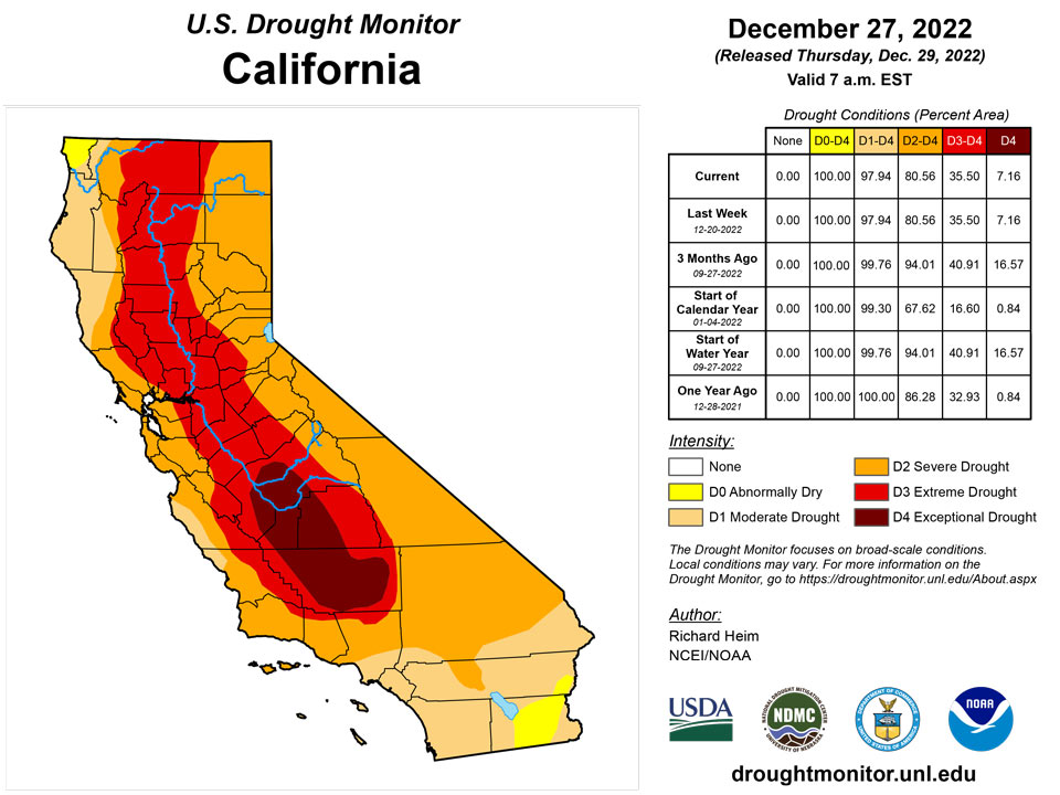
Pacific frontal systems brought rain and snow to coastal areas of the West, from northern California to Washington, and to parts of the Rockies. Two to 5 inches of precipitation fell along the coastal and Cascade ranges, with up to 10 inches locally in Washington. Amounts ranged up to 2 inches or more in the northern Rockies. Pockets of up to 1 inch of precipitation were found over the central Rockies, but for the states further south, southern California, and the intermountain basin, little to no precipitation occurred. Since this is the wet season in the Pacific Northwest, the heavy precipitation this week resulted in month-to-date totals that were barely above normal in some areas, and 3-month precipitation totals were still below normal across most of the Pacific Northwest. Very dry SPI values were still evident at the 6-month time scale in spite of this week’s precipitation. Soils were saturated and real-time and 7-day stream levels rose significantly in response to the rain, but 28-day streamflow levels, which are more relevant for drought monitoring, were still very low as of the Tuesday morning valid date of this USDM. Snow depth increased at some sites in northern Washington and the Idaho to Colorado mountains, but most locations in the Pacific Northwest experienced no change or a decrease in snow depth. Reservoirs in Oregon continued very low across the state, with some of the large reservoirs (e.g., Owyhee, Warm Springs, Prineville, Howard Prairie) less than 15% full. Most of the reservoirs across the Pacific Northwest saw very little change in reservoir levels since the beginning of the month. D1 was pulled back in those parts of Washington that had the heaviest precipitation and reflected improvement at 1- to 3-month time scales, but most of the D1 and the D0 were kept in place across the Pacific Northwest to reflect the aggregate indicators and conditions at all time scales. The bulk of the precipitation that fell in California occurred near the end of the USDM week. This precipitation, and the precipitation that followed after the Tuesday morning valid time, will be evaluated in next week’s USDM. No change was made to the rest of the West region outside of Washington.
Caribbean
This week was drier than normal across most of Puerto Rico, with the month to date unusually dry. D0 (abnormally dry) was added along the northwest and southern coasts where upper-layer soil moisture was drying; D0 was added to northeast Puerto Rico where streamflow was low. Local observers noted that the grass was beginning to turn yellowish along the southern coast of Puerto Rico, especially in the southeast.
Rain was plentiful during the fall in the U.S. Virgin Islands. Although this is the dry season, conditions have been unusually dry in recent weeks. Rohlsen Airport on St. Croix had its driest Nov 22-Dec 21 out of 63 years, while East Hill on the eastern end of the island, had its second driest Nov 22-Dec 21 out of 49 years. Weather reporters indicate that St. Croix received from 0.13 inches to 0.54 inches, with both extremes on the western end of the island, while St. Thomas received 0.04 to 0.24 inches, and St. John received 0.90 inches or less.
The lack of rain turned the Standardized Precipitation Index negative on the one-month time scale for all three islands. The values for St. Croix and St. Thomas indicated severe to extreme drought, so abnormal dryness (D0) was introduced on those islands. St. John received more rainfall than the other islands for the week, keeping its one-month SPI at a moderate drought level, so it remained free of abnormal dryness. The SPI values at longer time scales remained neutral or wet for all islands.
Well levels benefited from the fall precipitation, but the distance from the land surface to the water level has begun to increase again. St. Croix’s Adventure 28 well was 26.14 feet below the land surface on Dec. 26. St. Thomas’ Grade School 3 well was 8.35 feet below land surface on Dec. 26 after dropping more than 6.5 feet in the past nearly seven weeks. The Susannaberg DPW 3 well on St. John was 9.09 feet below land surface on Dec. 27.
Pacific
Drier- and colder-than-normal weather dominated Alaska, but with near to above-normal snowpack, no change was made to the depiction in Alaska, which remained free of drought and abnormal dryness.
Hawaii was mostly drier than normal this week, but this followed a very wet week last week, so no changes were made this week.
The Republic of Palau received slightly less than the desired 2 inches per week at Palau IAP and Koror COOP with 1.89 and 1.61 inches, respectively. Adequate rainfall in previous weeks should sustain them.
The Mariana Islands all had plenty of rain. Guam received 2.59 inches, while Rota reported 10.94 inches, including 8.24 inches on Dec. 27 alone. Saipan received from 1.88 to 2.44 inches at the three reporting sites. These islands need an inch weekly to meet minimum water needs.
The Federal States of Micronesia were mixed with most locations reporting receiving less than two inches needed to meet minimum water needs per week. Kapingamarangi, in severe drought (D2), received 0.78 inches, while Lukunor and Ulithi, both at D0, received 0.8 and 0.94 inches, respectively. Nukuoro reported 0.31 inches and may be abnormally dry soon without more rain. Several days of data were missing for Fananu, Pingelap and Kosrae so their locations were not evaluated this week. Chuuk, Woleai and Pohnpei reported 2.02, 4.36 and 4.66 inches, respectively.
The Marshall Islands were mostly below 2 inches of precipitation for the week, except for Mili, which received 2.65 inches for the past week. Abnormal dryness (D0) was introduced for Jaluit, which received 1.71 inches for the past week after several weeks of slightly below normal rainfall. December precipitation through the 27th for Jaluit amounted to 5.93 inches. Ailinglaplap and Kwajalein remained at D0 and received 1.54 and 0.95 inches, respectively. Wotje reported no rain for the week, but had ample rain recently. Majuro received 1.73 inches, and the reservoir held 23.185 million gallons on Dec. 27.
American Samoa reported adequate rainfall. Pago Pago, Siufaga Ridge and Toa Ridge received just about an inch of rain or more, which is the amount these islands need to meet minimum water needs.
Looking Ahead
As the cold air mass over the eastern CONUS exited out of the country during December 27-29, a strong Pacific weather system moved into the West, bringing abundant rain and snow. The western weather system will move across the West and into the central part of the country, while an upper-level ridge shifts eastward to dominate the weather over the East Coast. This combination will result in warmer-than-normal temperatures for much of the CONUS, especially east of the Rockies, and wet conditions from the Lower Mississippi Valley to eastern Great Lakes. The Pacific system will spread several inches of precipitation across much of the West, with 1 to 4 inches already having fallen through December 28. Predicted precipitation amounts for December 29-January 3 range from 1 to 4 inches over the Rockies and higher terrain of the intermountain basin, and from 4 to 10 inches or more along the immediate Pacific Coast, especially in California and the Sierra Nevada. As the weather system moves further east, 1 to 4 inches of precipitation is expected from east Texas to the Mid-Mississippi Valley and in the Southeast. One to 2 inches of precipitation is predicted across the central Plains to Upper Mississippi Valley, across parts of the Great Lakes, and into New England, with half an inch to an inch across the rest of the CONUS east of the Mississippi River. For January 4-10, the ridge over the eastern half of the CONUS is expected continue, keeping most of the country east of the Rockies warmer than normal, while the West averages near to cooler than normal. Odds favor above-normal precipitation across most of the CONUS, with near to below normal precipitation favored for parts of the northern and southern Plains. Drier-than-normal weather with near-normal temperatures are expected for northern Alaska, and wetter and warmer than normal for southern Alaska.
Author(s):
Richard Heim, NOAA/NCEI
Denise Gutzmer, National Drought Mitigation Center
Dryness Categories
D0 Abnormally Dry—used for areas showing dryness but not yet in drought, or for areas recovering from drought.
Drought Intensity Categories
D1 Moderate Drought
D2 Severe Drought
D3 Extreme Drought
D4 Exceptional Drought
Drought or Dryness Types
S Short-term, typically less than 6 months (agriculture, grasslands)
L Long-term, typically more than 6 months (hydrology, ecology)
SL Area contains both short- and long-term impacts
Source: National Drought Mitigation Center
