


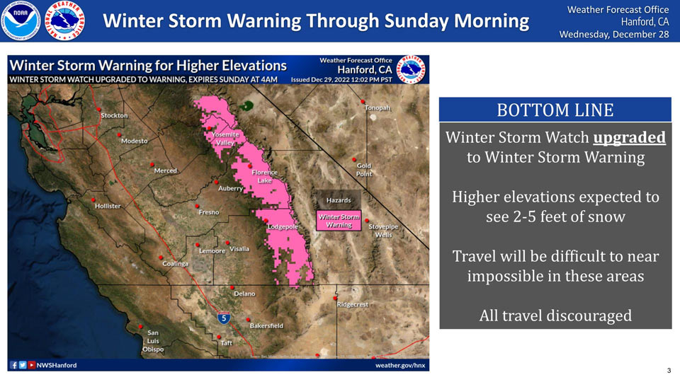
December 29, 2022 - The National Weather Service Hanford Office reports the winter storm watch has been upgraded to a winter storm warning and is issued until Sunday, January 1st 2022 at 4:00 A.M. PST.
Heavy snow is forecasted for the mountains and higher elevations and travel will be difficult to near impossible. All travel is discouraged.
Winter Storm Warning
URGENT - WINTER WEATHER MESSAGE
National Weather Service Hanford CA
1151 AM PST Thu Dec 29 2022

Yosemite NP outside of the valley-Upper San Joaquin River-
Kaiser to Rodgers Ridge-Kings Canyon NP-Grant Grove Area-
Sequoia NP-South End of the Upper Sierra-
Including the cities of Tuolumne Meadows, Wawona,
Devils Postpile, Florence Lake, Lake Thomas Edison, Lake Wishon,
Huntington Lake, Shaver Lake, Cedar Grove, Grant Grove,
Hume Lake, Giant Forest, Lodgepole, and Johnsondale
1151 AM PST Thu Dec 29 2022

...WINTER STORM WARNING IN EFFECT FROM 10 PM THIS EVENING TO 4 AM
PST SUNDAY ABOVE 7000 FEET...

* WHAT...Heavy snow expected above 7,000 feet. Total snow
  accumulations of 1 to 2 feet above 7,000 feet. Total snow
  accumulations of 3 to 4 feet possible above 8,000 feet.
  Isolated accumulations of 5 feet possible above 9000 feet. Winds
  could gust as high as 50 mph.

* WHERE...Sierra Nevada from Yosemite National Park to Tulare
  County.

* WHEN...From 10 PM this evening to 4 AM PST Sunday.

* IMPACTS...Travel could be very difficult to impossible. The
  hazardous conditions could impact the morning or evening
  commute.

* ADDITIONAL DETAILS...Expect a rise in snow levels to above 8,000
  feet at times during Friday into Saturday morning.

PRECAUTIONARY/PREPAREDNESS ACTIONS...

If you must travel, keep an extra flashlight, food, and water in
your vehicle in case of an emergency.

The latest road conditions for the state you are calling from can
be obtained by calling 5 1 1.
Source: NWS
