


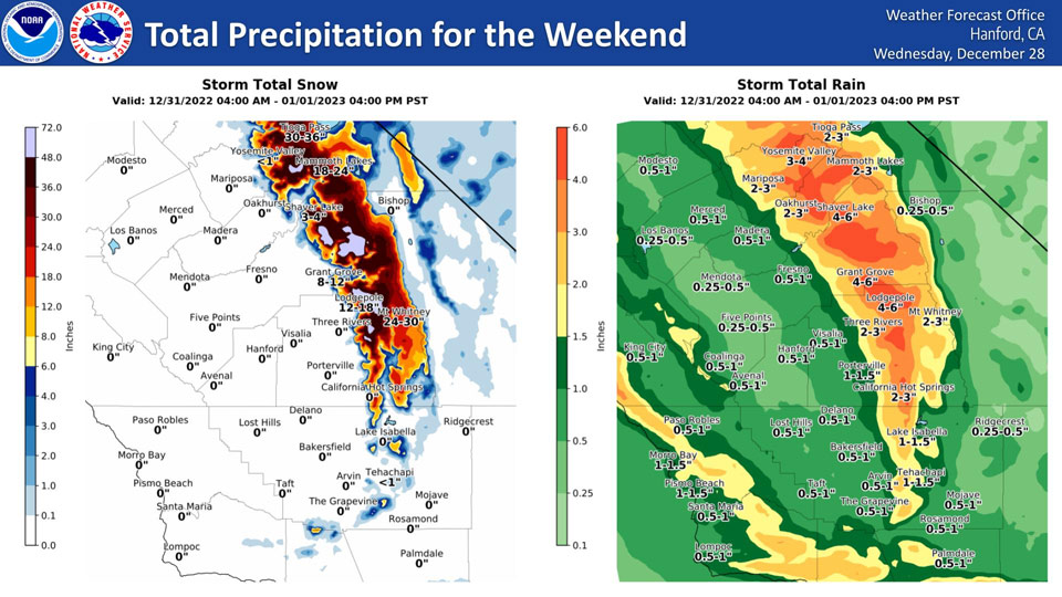
Mariposa, Saturday to Sunday Projected Precipitation: 2.00" to 3.00"
Oakhurst, Saturday to Sunday Projected Precipitation: 2.00" to 3.00"
Yosemite Valley, Saturday to Sunday Projected Precipitation: 3.00" to 4.00"
December 31, 2022 - The National Weather Service Hanford Office reports the rain and snow forecast totals for this weekend's major event.
Area Forecast Discussion
National Weather Service Hanford CA
233 AM PST Sat Dec 31 2022
.SYNOPSIS...
Atmospheric river continues to slowly push southward this morning.
A bulk of the precipitation is expected to fall later this morning
through the afternoon, leading to a chance of nuisance flooding
through the district. Light precip may occur Sunday through
Tuesday, before another atmospheric river may impact Central
California Wednesday and Thursday.
&&
.DISCUSSION...
Moderate rainfall continues to fall in parts of the Sierra Nevada
and foothills this morning, with snow levels currently around
8500 feet. Some areas such as Yosemite Valley have recorded over
2.5 inches of rain in the last 12 hours. Similar observations
throughout the foothills have been observed in the foothills north
of Fresno County. This rainfall in the foothills and mountains
will lead to continued chances of isolated rockslides in steep
canyons throughout the day, especially when the cold front this
afternoon pushes through the region. Strong winds along the
Coastal Range are being advertised out ahead of the front later
this morning and the afternoon, so a Wind Advisory has been
hoisted along this region through 4 PM this afternoon for gusts up
to 55 mph. Breezy conditions with wind gusts 30-35 mph may
briefly materialize in the San Joaquin Valley by mid to late
morning today, but will not maintain as the front passes through.
As the front passes through the region, the HREF ensemble mean is
forecasting rainfall rates to increase over the Sierra Nevada and
foothills up to around one half of an inch per hour, with about
one quarter of an inch an hour in the San Joaquin Valley.
Rainfall rates of higher values are possible in the higher
elevations of the Sierra Nevada right below the snow line. For the
valley, this rainfall could lead to isolated nuisance flooding,
especially in areas with poor drainage that have already seen
rainfall earlier this week. Area rivers are expected to rise in
response to this rainfall in the afternoon and evening hours.
Currently Bear Creek is forecast to hit Monitor Stage later
tonight, but not reach flood stage. As the front passes through,
expect snow levels to around 6500-7000 feet in the Sierra Nevada.
Heavy snow load is expected at these elevations or higher in the
Sierra Nevada as the front passes through.
By around midnight tonight, the bulk of the rainfall and snowfall
across the CWA will likely be over, with the exception orographic
showers leading to continued snowfall in the Sierra Nevada. Model
guidance is showing some light snow falling over the Tehachapi
Mountains, but not reaching advisory criteria late this evening.
By early Sunday morning light precipitation is likely to be
occuring in the mountains, including through Kern County on the
northward facing slopes of the Tehachapi's. NBM probabilities are
showing a 9-in-10 chance of snow levels remaining above 4300
feet, so issues with snowfall over the Grapevine are unlikely to
occur as of this writing. As the system exits the region on
Sunday, model guidance is suggesting periods of breezy conditions
will be possible just below pass level in Kern County. A Wind
Advisory may be needed in for these areas Sunday.
A lull in activity is being advertised by ensembles early next
week, with only light precipitation occuring in association with
a weak atmospheric disturbance passing over the region. A more
significant system is being shown by both the GEFS and the EPS by
Wednesday and Thursday of next week. The added rainfall over the
area may once again lead to nuisance flooding concerns as soil
over the area will remain wet. More details to come on this system
after the current AR event is done.
&&
.AVIATION...VFR/MVFR conditions will prevail for the next 24
hours. Occasional IFR/LIFR conditions in heavier showers and
higher terrains possible.
&&
.AIR QUALITY ISSUES...
ISSUED: 12/30/2022 13:37
EXPIRES: 12/31/2022 23:59
On Saturday December 31 2022,Fireplace/Wood Stove Burning Status
is: Burning Discouraged in Fresno, Kern, Kings, Madera, Merced,
and Tulare Counties, and Kern (Greater Frazier Park Area) and
Sequoia National Park and Forest.
&&
.CERTAINTY...
The level of certainty for days 1 and 2 is high.
The level of certainty for days 3 through 7 is medium.
Certainty levels include low...medium...and high. Please visit
www.weather.gov/hnx/certainty.html for additional information
and/or to provide feedback.
&&
.HNX WATCHES/WARNINGS/ADVISORIES...
Flood Watch through late tonight for CAZ300>322-324-325.
Wind Advisory until 4 PM PST this afternoon for CAZ300-308-313.
Winter Storm Warning until 4 AM PST Sunday for CAZ323-326>331.
Source: NWS
