


January – April 2023 Highlights:
• La Niña will continue through the winter, but is expected to weaken by late spring or Summer.
• Temperatures will likely average above normal through April.
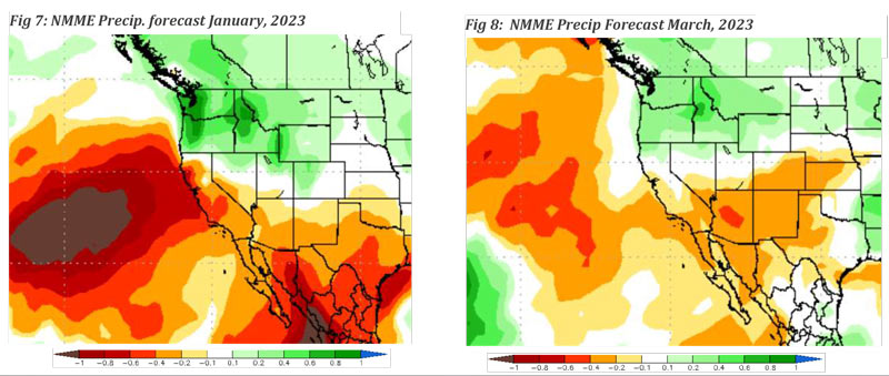
• Below normal precipitation expected, especially in January and February
• The 2022 – 2023 winter “rainy season” will likely finish below normal again this season.
• Long term drought will continue into 2023.
January 1, 2023 - Weather Discussion: A pair of strong winter storms brought widespread and beneficial wetting rain and mountain snow at the beginning of December. One storm arrived on the 3rd and
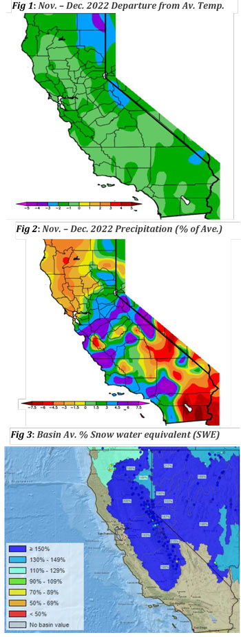 4th, which impacted Central and Northern CA. A second, more powerful, storm brought heavy rain to Central and Southern CA on the 10th. The two storms summed together resulted in one of wettest Decembers of the past few years.
 The second storm in particular had abundant moisture available, resulting in especially heavy precipitation on west and southwest aspects of the Central Coast and the transverse ranges of Southern CA. Local amounts of over 2’ of rain occurred on the central coast and over 12”was recorded in areas of the Sierra Foothills and the mountains of Santa Barbara County to Los Angeles County. Lighter amounts occurred south and east of Los Angeles County, but even there, amounts were enough to keep fire activity minimal the rest of the month.
Temperatures were generally cooler than normal in December due to the two storms and frequent cold air intrusions across the Great Basin. Offshore wind events last month were very minor and inconsequential. Tule Fog developed around the 17th across the San Joaquin Valley which was very persistent the week of the 19th. But, later in the month, strong ridging over the Eastern Pacific drew closer to the region, resulting in warmer than normal conditions around the 25th. However, due to the cold temperatures early and late in the month, most of the Geographic Area would finish the month of December with below normal temperatures.
Fuels Discussion
The storms of December brought a wholesale change in fuel conditions. Dead fuel moisture (DFM) was at near record low levels at the beginning of December, but by the middle of the month, DFM was well above average. Seasonal grasses began to grow rapidly at elevations below 3,000 feet and, at the time of this writing, many areas of Southern CA have an extensive grass crop. Some native shrubs are showing new growth and leaves, but more substantial growth is still a few weeks’ worth of warmer weather away.
Snowpack totals climbed to well above normal levels across the Sierras with snow water equivalent (SWE) figures over 150% over most watersheds of Central CA. The Sierras over 7,000 feet are covered under several feet of snow, but there has been some meltout in open areas of the Foothills.
The combination of extensive grass growth at lower elevations and deep snow in the high country should keep fire potential minimal the next few weeks. However, DFM may drop low enough to allow for ignition in finer fuels between these two zones – especially in areas from 3,000 feet or so to around 6,000 feet – if dry, windy conditions return in January and February.
SOUTH OPS OUTLOOK
A La Niña remains in place across the equatorial Pacific, but there are signs that the strength of the negative ENSO index is beginning to wane. According to the latest outlook from the Climate Prediction Center (CPC), there is a 71% chance of an ENSO-neutral condition developing during the February through April 2023 time period. Indeed, the depth and areal coverage of water than normal Sea Surface Temperatures (SST) appears to be shrinking and there is a good probably that neither a La Niña nor an El Niño will be impactful by the spring.
What might a slowly dissipating La Niña might mean for the upcoming winter and early spring months? Looking at recent monthly precipitation and SST charts, 2012 might be the closest analog year. If the composite of long range models is correct, the ENSO index should be around -0.5°C below normal by March 2023, which is similar to what was recorded in 2012. That year, the ENSO was trending upward after a prolonged period of La Niña conditions (23 consecutive months of -0.4°C vs the current 28+ months… and counting).
The 2012 rainy season started off relatively wet before conditions turned drier in January and February. But there was a “late precipitation rally” in March and April when well above normal precipitation was recorded. In fact, during that season, March and April were far wetter than the December-February time periods (the climatologically wettest months of the year for most of South Ops). While there are other factors that govern synoptic scale weather patterns across the Pacific, the ENSO is one of the most significant in determining winter and spring precipitation.
Given the expectation of a decreasing ENSO signal, we are expecting a below average period of precipitation from January to February, followed by wetter than normal conditions in March and April. Temperatures are expected to be above normal overall, especially across inland areas. DFM will trend below normal and there will be some fire potential during offshore wind events (a near normal frequency is expected). Live fuels should; however, keep large fire potential low the next few months. Seasonal grasses will begin to cure in March, but the expectation of wetter weather in the early spring may forestall “grass fire season for a few weeks. Large fire potential, thus, may remain near normal until May, then an above normal potential may return for the rest of the spring.
 Source: NIFC