


Includes Mariposa, Oakhurst and Yosemite Valley
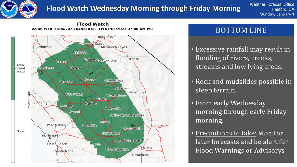
January 3, 2023 - The National Weather Service Hanford Office reports a Flood Watch is in effect for the San Joaquin Valley and surrounding foothills and mountains below 7000 feet from 4:00 A.M. Wednesday through 4:00 A.M. Friday.
A Flash Flood Watch means excessive rainfall may result in flooding of rivers creeks and streams, as well as rock and mudslides in steep terrain.
Flooding may occur in urban and flood prone areas.
Flood Watch
Flood Watch
National Weather Service Hanford CA
345 AM PST Tue Jan 3 2023

/00000.0.ER.000000T0000Z.000000T0000Z.000000T0000Z.OO/
West Side Mountains north of 198-Los Banos - Dos Palos-Merced -
Madera - Mendota-Planada - Le Grand - Snelling-Coalinga - Avenal-
West Side of Fresno and Kings Counties-Caruthers - San Joaquin -
Selma-Fresno-Clovis-West Side Mountains South of 198-Buttonwillow -
Lost Hills - I5-Delano-Wasco-Shafter-Hanford - Corcoran - Lemoore-
Visalia - Porterville - Reedley-Buena Vista-Bakersfield-Southeast
San Joaquin Valley-South End San Joaquin Valley-Mariposa Madera
Foothills-Mariposa-Madera Lower Sierra-Fresno-Tulare Foothills-
Fresno-Tulare Lower Sierra-South End Sierra Foothills-South End of
the Lower Sierra-Yosemite NP outside of the valley-Yosemite Valley-
San Joaquin River Canyon-Upper San Joaquin River-Kaiser to Rodgers
Ridge-Grant Grove Area-Sequoia NP-South End of the Upper Sierra-Kern
River Valley-Piute Walker Basin-Tehachapi-Grapevine-Frazier Mountain
Communities-Mojave Desert Slopes-
Including the cities of Blackwells Corner, Giant Forest, Le Grand,
Richgrove, Sanger, San Luis Reservoir, Auberry, Lake Thomas Edison,
Fresno, Goshen, Huntington Lake, Tehachapi, Lodgepole, Coarsegold,
Merced, Lake Mcclure, Visalia, Hanford, Selma, Shaver Lake,
McKittrick, Wasco, Buttonwillow, North Fork, Florence Lake, Mojave,
Atwater, Bakersfield, Johnsondale, El Portal, Yosemite Valley, Los
Banos, Shafter, Camp Nelson, Lost Hills, Kernville, Hume Lake,
Coalinga, Millerton Lake, Kingsburg, Lake Wishon, Kerman, Mariposa,
Taft, Lamont, Avenal, Bass Lake, Tuolumne Meadows, Fish Camp, Devils
Postpile, Kettleman City, Arvin, Oakhurst, Porterville, Frazier
Park, Lake Isabella, Delano, Alpaugh, Planada, Five Points, Lebec,
Grapevine, Lemoore, Corcoran, Grant Grove, Parlier, Wawona, Lemoore
Station, Madera, and Tulare
345 AM PST Tue Jan 3 2023

...FLOOD WATCH NOW IN EFFECT FROM EARLY WEDNESDAY MORNING THROUGH
LATE THURSDAY NIGHT...

* WHAT...Flooding caused by excessive rainfall continues to be
  possible.

* WHERE...A portion of central California, including the following
  areas, Bakersfield, Buena Vista, Buttonwillow - Lost Hills - I5,
  Caruthers - San Joaquin - Selma, Coalinga - Avenal,
  Delano-Wasco-Shafter, Frazier Mountain Communities, Fresno-Clovis,
  Fresno-Tulare Foothills, Fresno-Tulare Lower Sierra, Grant Grove
  Area, Grapevine, Hanford - Corcoran - Lemoore, Kaiser to Rodgers
  Ridge, Kern River Valley, Los Banos - Dos Palos, Mariposa Madera
  Foothills, Mariposa-Madera Lower Sierra, Merced - Madera -
  Mendota, Mojave Desert Slopes, Piute Walker Basin, Planada - Le
  Grand - Snelling, San Joaquin River Canyon, Sequoia NP, South End
  San Joaquin Valley, South End Sierra Foothills, South End of the
  Lower Sierra, South End of the Upper Sierra, Southeast San Joaquin
  Valley, Tehachapi, Upper San Joaquin River, Visalia - Porterville
  - Reedley, West Side Mountains South of 198, West Side Mountains
  north of 198, West Side of Fresno and Kings Counties, Yosemite NP
  outside of the valley and Yosemite Valley.

* WHEN...From early Wednesday morning through late Thursday night.

* IMPACTS...Excessive runoff may result in flooding of rivers,
  creeks, streams, and other low-lying and flood-prone locations.
  Flooding may occur in poor drainage and urban areas. Area creeks
  and streams are running high and could flood with more heavy rain.

* ADDITIONAL DETAILS...
  - Atmospheric river with high snow levels expected to bring
    periods of moderate to heavy rainfall for mainly Fresno
    County northward beginning early Wednesday morning and areas
    south of Fresno County beginning Wednesday evening.
    Precipitation will continue until late Thursday night in all
    areas.
    Bear Creek at McKee Road forecast to reach monitor stage by
    Thursday morning.
  - http://www.weather.gov/safety/flood

PRECAUTIONARY/PREPAREDNESS ACTIONS...

You should monitor later forecasts and be alert for possible Flood
Warnings. Those living in areas prone to flooding should be prepared
to take action should flooding develop.
Source: NWS
