


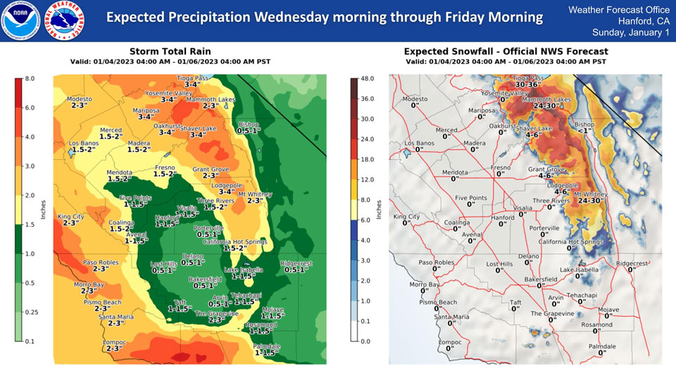
Mariposa, Wednesday to Friday Projected Precipitation: 3.00" to 4.00"
Oakhurst, Wednesday to Friday Projected Precipitation: 3.00" to 4.00"
Yosemite Valley, Wednesday to Friday Projected Precipitation: 3.00" to 4.00"
January 3, 2023 - The National Weather Service Hanford Office reports a storm system will bring heavy rain and snow to central California early Wednesday through early Friday.
Area Forecast Discussion
National Weather Service Hanford CA
402 AM PST Tue Jan 3 2023
.SYNOPSIS...The active pattern continues for at least the next
several days. A much stronger system will move through the area
between Wednesday afternoon and Thursday evening and bring a
variety of weather impacts to Central California. A respite in the
activity is expected on Friday before another low pressure system
moves through the region this weekend.
&&
.DISCUSSION...Snow showers are mainly dissipating over the Sierra
Nevada late tonight, so we have cancelled the Winter Weather
Advisory. We will get a brief break from precipitation today;
however, moderate to heavy showers and high elevation snow are in
store for both Wednesday and Thursday. We have issued a Flood
Watch for much of our forecast area, especially outside of the
Kern County desert and higher elevations of the Sierra Nevada.
Any place that receives rainfall could experience periods of at
least nuisance flooding, and the ground in these areas is
saturated due to previous storms. We are also expecting another
period of strong and gusty southerly winds over the higher terrain
along the west side of the San Joaquin Valley and towards the
Grapevine with the Wednesday/Thursday storm. Gusts will likely be
as strong as what occurred on Saturday.
Expect a lull in activity for Friday between low pressure
systems. However, for the weekend, there will be yet another storm
system. This one appears to weaken as it moves southward from
Northern California, so it will produce lesser amounts of
precipitation. The more rain we receive, the higher the chance for
impacts such as additional rises in rivers, creeks, and streams,
as well as flooding and debris flows. This active pattern
continues into next week, although some of the deterministic
models suggest the trough pattern and associated precipitation
will shift northward into Northern California. Ensemble guidance
continues to hold onto an active pattern for us into early next
week.
The Climate Prediction Center shows continued chances of above
average precipitation for much of next week, or the 10th-13th.
There is a moderate risk of heavy precipitation for our entire
forecast area with heavy snow mainly in the Sierra.
&&
.AVIATION...Increasing MVFR conditions with areas of mountain
obscuring IFR in low clouds and precipitation continuing through
15Z Tue in the Sierra Nevada, Tehachapi Mountains and adjacent
foothills and valley facing slopes. A slow improvement to mainly
VFR is expected after 15Z Tue. Elsewhere VFR conditions will
prevail across the central CA interior for the next 24 hours.
&&
.AIR QUALITY ISSUES...On Tuesday January 3 2023, Fireplace/Wood
Stove Burning Status is: No Burning Unless Registered in Fresno
and Kern Counties. Burning Discouraged in Kings, Madera, Merced,
and Tulare Counties, and Kern (Greater Frazier Park Area) and
Sequoia National Park and Forest.
&&
.CERTAINTY...
The level of certainty for days 1 and 2 is medium.
The level of certainty for days 3 through 7 is medium.
Certainty levels include low...medium...and high. Please visit
www.weather.gov/hnx/certainty.html for additional information
and/or to provide feedback.
&&
.HNX WATCHES/WARNINGS/ADVISORIES...
Flood Watch from Wednesday morning through late Thursday night
for CAZ300>327-329>336-338.
Winter Storm Warning from 7 AM Wednesday to 4 AM PST Friday for
CAZ323-326>330.
Source: NWS
