


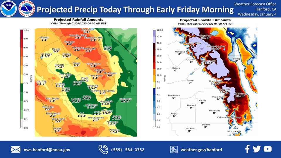
Mariposa, Wednesday to Friday Projected Precipitation: 3.00" to 4.00" Updated to 4.00" to 6.00"
Oakhurst, Wednesday to Friday Projected Precipitation: 3.00" to 4.00" Updated to 4.00" to 6.00"
Yosemite Valley, Wednesday to Friday Projected Precipitation: 3.00" to 4.00" Updated to 4.00" to 6.00"
January 4, 2023 - The National Weather Service Hanford Office reports a strong storm system will impact Central California through early Friday morning, resulting in snow in the Sierra Nevada and rain in the San Joaquin Valley.
Snow levels will start at around 5,000 feet this morning, before rising to about 8,000 feet this afternoon. Snow levels will drop back down to around 5,000 feet Thursday.
The majority of this precipitation will fall tonight and Thursday morning.
Area Forecast Discussion
National Weather Service Hanford CA
517 AM PST Wed Jan 4 2023
.SYNOPSIS...Active weather continues for at least several more
days. The next potent storm system will begin impacting the area
this morning into Thursday evening. On Friday, calmer weather is
expected before another low pressure system arrives into the area
Saturday.
&&
.DISCUSSION...
The developing storm system well off the coast of northern
California is steering a plume of subtropical moisture into the
California coast and associated low clouds and precipitation are
beginning to push into western portions of our area. This is the
beginning of another significant rain, wind and snow event for the
central California interior. Rainfall amounts as much as 1-2
inches are expected in the San Joaquin Valley before the system
pushes east of the area late Thursday night. Foothill locations
below the snow line will receive around 2-4 inches of rain with
locally higher amounts. Even desert areas are slated to accumulate
around 1 inch of rainfall from this system. As much as 1-3 inches
of liquid will also fall in the Kern County mountains. Due to the
excessive rainfall that will impact our area, a Flood Watch is in
effect through 4 AM Friday for all areas outside the desert zones
that are below the snow level.
The snow level will be varying through the event, starting out
around 5500-6000 ft this morning, then raising to around 8000 ft
through this afternoon, before lowering back to near 6000 ft by
later tonight and Thursday morning, then near 5000 ft by Thursday
night/Friday morning as precipitation tapers off. Total snow
accumulations will be as much as 3 to 5 feet at the highest
elevations and around 1-2 ft from 6000 to 7000 ft. A Winter Storm
Warning is in effect for the Sierra from Sequoia National Park
northward until 5 AM Friday.
The other component of this system will be some strong gusty
winds. Probabilities of seeing southerly wind gusts over 58 mph
through the Grapevine and downsloping into the south end of the
Valley are running around 55 percent. A High Wind Warning is in
effect for these strong winds. Wind gusts over 35 mph are also
likely in the remainder of the San Joaquin Valley and the
foothills, with gusts over 45 mph expected over the West Side
mountains. Wind Advisories are in effect for these areas today
through early Thursday morning.
Ensemble model solutions show a brief break from the
precipitation Friday under weak ridging, then another less
impactful system Saturday and Sunday, followed by more
precipitation Monday and Tuesday associated with yet another
system.
&&
.AVIATION...Increasing MVFR conditions with areas of mountain
obscuring IFR and local LIFR conditions in low clouds and
precipitation will become prevalent across the Sierra Nevada and
Tehachapi Mountains and the adjacent foothills and valley facing
slopes after 15Z today. Areas of MVFR in rain and low clouds over
the San Joaquin Valley and desert areas after 12Z today.
&&
.AIR QUALITY ISSUES...
On Wednesday January 4 2023,Fireplace/Wood Stove Burning Status
is: No Burning Unless Registered in Fresno and Kern Counties.
Burning Discouraged in Kings, Madera, Merced, and Tulare Counties,
and Kern (Greater Frazier Park Area) and Sequoia National Park and
Forest.
&&
.CERTAINTY...
The level of certainty for days 1 and 2 is high.
The level of certainty for days 3 through 7 is medium.
Certainty levels include low...medium...and high. Please visit
www.weather.gov/hnx/certainty.html for additional information
and/or to provide feedback.
&&
.HNX WATCHES/WARNINGS/ADVISORIES...
Flood Watch from 4 AM PST early this morning through late
Thursday night for CAZ300>327-329>336-338.
Wind Advisory until 5 AM PST Thursday for CAZ300-304-308-313-316.
Wind Advisory from 10 AM this morning to 5 AM PST Thursday for
CAZ301>303-317.
Wind Advisory from 2 PM this afternoon to 5 AM PST Thursday for
CAZ305>307-309>312-314-315-319-321.
Winter Storm Warning until 4 AM PST Friday for CAZ323-326>330.
High Wind Warning until 5 AM PST Thursday for CAZ334>336.
Source: NWS
