


Includes Mariposa County, Madera County, and Yosemite National Park
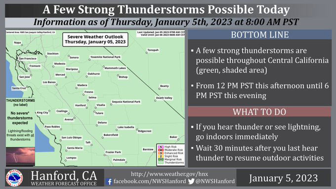
January 5, 2023 - The National Weather Service Hanford Office reports a few strong thunderstorms are possible throughout Central California today.
Dangerous lightning, small hail, and wind gusts near 45 mph are hazards associated with strong thunderstorms.
Any thunderstorm can produce intense rainfall rates, leading to localized flooding.
Area Forecast Discussion
National Weather Service Hanford CA
1254 AM PST Thu Jan 5 2023
.SYNOPSIS...
Active weather continues for at least several more days...after this
morning rain, a brief respite will occur before stormy conditions
return this evening into Thursday morning. On Friday, calmer will
prevail ahead of the next low pressure system that is set to arrive
on Saturday and continue until Sunday. Another strong system is
expected on Monday into Tuesday.
&&
.DISCUSSION...
The main band of moderate to heavy precipitation associated with
the atmospheric river is currently over our forecast area and is
moving into the Sierra Nevada with some embedded isolated
thunderstorms. Just ahead of this band were very strong winds,
including over the Tehachapi Mountains and the Grapevine. The
Grapevine Peak RAWS just above I-5, or north of the Ft. Tejon
exit, reported a gust of 106 mph. While this particular station is
located well above the freeway, there have been stations near the
Grapevine exit of I-5 have been reporting gusts around 60 to 70
mph earlier in the evening. Numerous locations in the Central
Valley were gusting to over 40 mph with some gusts just east of
Bakersfield reaching near 60 mph.
Expect additional rounds of precipitation overnight tonight. The
cooler air will arrive over much of the region by the morning
hours. Winds will likely decrease considerably by the early
morning hours just before sunrise while this system gradually
pushes further inland. Probabilistic data show we have already
passed the peak of this wind event, and latest high resolution
forecast shows these winds relaxing. However, the next threat
will be afternoon and early evening convection, or scattered
heavier showers with isolated thunderstorms, due to the arrival of
cold, unstable air. Any thunderstorms can produce gusty winds,
frequent lightning, small hail and brief heavy precipitation.
Lingering showers will likely persist overnight Thursday night
into early Friday morning. For Friday, we should get a brief break
from active weather, although precipitation returns on Saturday
due to another low pressure system. High resolution guidance shows
the majority of the moisture traveling over Northern California,
so forecast precipitation should be lower with this system, at
least for Saturday into Sunday morning before the front pushes
southward into our portion of Central CA.
A stronger low pressure system arrives Monday and lasts until at
least Tuesday, which could be enough to cause additional concerns
for flooding. Latest deterministic and ensemble guidance have
been consistently showing continued precipitation for this period.
This system is also accompanied with an atmospheric river, so the
snow levels will once again rise to around 7K-8K feet before the
cold front arrives late on Tuesday. It appears we'll get a break
from precipitation by the middle of next week. This break may once
again be brief as latest CPC data shows chances of above average
precipitation for Thursday into the following weekend, including a
moderate risk of heavy precipitation.
&&
.AVIATION...
Increasing MFR conditions with areas of mountain obscuring IFR
and local LIFR conditions in low clouds and precipitation will
become prevalent across the Sierra Nevada and Tehachapi Mountains
and the adjacent foothills and valley facing slopes through the
remainder of tonight. Areas of MVFR in rain and low cloud cover
over the San Joaquin Valley and desert areas. Gusty winds and Low
Level WInd shear is expected across the area.
&&
.AIR QUALITY ISSUES...
On Thursday January 5 2023, Fireplace/Wood Stove Burning Status
is: No Burning Unless Registered in Kern County. Burning
Discouraged in Fresno, Kings, Madera, Merced, and Tulare Counties,
and Kern (Greater Frazier Park Area) and Sequoia National Park
and Forest.
&&
.CERTAINTY...
The level of certainty for days 1 and 2 is high.
The level of certainty for days 3 through 7 is high.
Certainty levels include low...medium...and high. Please visit
www.weather.gov/hnx/certainty.html for additional information
and/or to provide feedback.
&&
.HNX WATCHES/WARNINGS/ADVISORIES...
Flood Watch through late Thursday night for CAZ300>327-329>336-
338.
Wind Advisory until 5 AM PST Thursday for CAZ300>317-319-321.
Winter Storm Warning until 4 AM PST Friday for CAZ323-326>330.
High Wind Warning until 5 AM PST Thursday for CAZ334>336.
Source: NWS
