


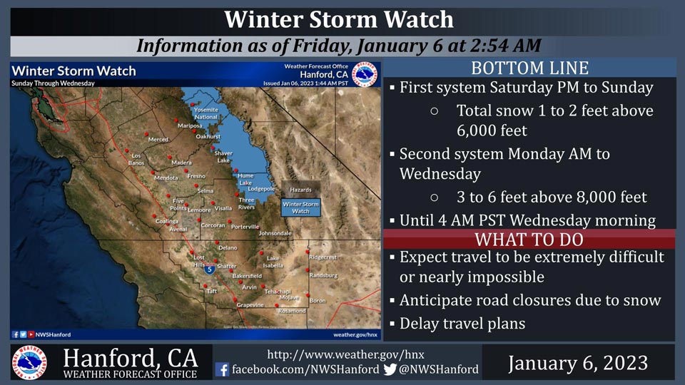
January 6, 2023 - The National Weather Service Hanford Office reports a Winter Storm Watch is in effect for the Sierra Nevada until 4:00 A.M.Wednesday.
Snow will start Saturday with 1 to 3 feet falling overnight.
A more intense system will impact the region Monday with an additional 3 to 6 feet of snowfall occurring.
Travel will be extremely difficult or impossible. If you plan to travel, consider alternate strategies. If you must travel, remember to carry tire chains, plenty of food, a good deal of water, warm clothing, and a flashlight in your vehicle.
Winter Storm Watch
URGENT - WINTER WEATHER MESSAGE
National Weather Service Hanford CA
143 AM PST Fri Jan 6 2023

Yosemite NP outside of the valley-Upper San Joaquin River-
Kaiser to Rodgers Ridge-Kings Canyon NP-Grant Grove Area-
Sequoia NP-
Including the cities of Tuolumne Meadows, Wawona,
Devils Postpile, Florence Lake, Lake Thomas Edison, Lake Wishon,
Huntington Lake, Shaver Lake, Cedar Grove, Grant Grove,
Hume Lake, Giant Forest, and Lodgepole
143 AM PST Fri Jan 6 2023

...WINTER STORM WATCH IN EFFECT FROM SATURDAY EVENING THROUGH
LATE TUESDAY NIGHT...

* WHAT...Heavy snow possible due to a couple of systems. With the
  first system on Saturday night into Sunday, expect snow amounts
  of one to two feet above 6,000 feet. With the second system on
  Monday morning until Tuesday night, expect 3 to 6 feet of snow
  wit locally heavier amounts above 8,000 feet and 18 inches to 3
  feet between 6,000 and 8,000 feet. Winds could gust as high as
  50 mph.

* WHERE...Sierra Nevada above 6,000 feet from Yosemite National
  Park to Tulare County.

* WHEN...From Saturday evening through late Tuesday night.

* IMPACTS...Travel could be very difficult to impossible. The
  hazardous conditions could impact the morning or evening
  commute. Gusty winds could bring down tree branches.

* ADDITIONAL DETAILS...On Monday, expect snow levels to rise to
  around 8,000 feet, then lowering Monday night into Tuesday.

PRECAUTIONARY/PREPAREDNESS ACTIONS...

Monitor the latest forecasts for updates on this situation.
Source: NWS
